Bosanska Krupa
| Bosanska Krupa Босанска Крупа | |
|---|---|
| Municipality and town | |
|
Top left:View of Krvsnica Valley in Una Forest Park, Top right: View of Temple of the Nativity of the Hoply Virgin (left) and City Mosque (right), Middle right:A footbridge in Ade River, Bottom left:Panorama view from Forress of Bosanska Krupa, Bottom right:City view, watermills in Una River | |
 Location of Bosanska Krupa within Bosnia and Herzegovina. | |
 Bosanska Krupa Location of Bosanska Krupa | |
| Coordinates: 44°53′N 16°09′E / 44.883°N 16.150°E | |
| Country |
|
| Government | |
| • Municipality president | Armin Halitović (Independent) |
| Population (2013 census) | |
| • Total | 29,659 |
| Time zone | CET (UTC+1) |
| • Summer (DST) | CEST (UTC+2) |
| Area code(s) | +387 37 |
.jpg)

Bosanska Krupa (Cyrillic: Босанска Крупа, pronounced [bɔ̌sanskaː krûpa]) is a town and municipality in northwestern Bosnia and Herzegovina, on the Una river. It is located 30 km (19 mi) northeast from Bihać (350 km away from Sarajevo). It is the seat of a municipality within the Una-Sana Canton of the Federation of Bosnia and Herzegovina.
Geography
Bosanska Krupa is located on the border within the Federation of Bosnia and Herzegovina adjacent to the municipalities of Bužim, Cazin, Bihać, Bosanski Petrovac, Sanski Most, and Krupa na Uni. The last mentioned municipality is part of the Republika Srpska and was part of the Bosanska Krupa municipality before the Bosnian War, but after the Dayton Agreement it became separate municipality.
Settlements
• Arapuša • Bag • Banjani • Baštra • Benakovac • Bosanska Krupa • Dobro Selo • Donja Suvaja • Donji Dubovik • Donji Petrovići • Drenova Glavica • Glavica • Gorinja • Gornja Suvaja • Gornji Bušević • Gornji Petrovići • Gudavac • Hašani • Ivanjska • Jasenica • Jezerski • Konjoder • Lubarda • Ljusina • Mahmić Selo • Mali Badić • Mali Dubovik • Mali Radić • Mrazovac • Osredak • Ostrožnica • Bosanska Otoka • Perna • Pištaline • Potkalinje • Pučenik • Srednji Bušević • Srednji Dubovik • Varoška Rijeka • Velika Jasenica • Veliki Badić • Veliki Dubovik • Veliki Radić • Vojevac • Voloder • Vranjska i Zalin.
Demographics
| Ethnic Composition | |||||||||||||
| Year | Serb | % | Bosniaks | % | Croats | % | Yugoslavs | % | Others | % | Total | ||
|---|---|---|---|---|---|---|---|---|---|---|---|---|---|
| 1961 | 20,453 | 44.44% | 23,721 | 51.54% | 453 | 0.98% | 1,271 | 2.76% | 122 | 0.27% | 46,020 | ||
| 1971 | 18,230 | 35.84% | 31,842 | 62.61% | 286 | 0.56% | 239 | 0.46% | 259 | 0.50% | 50,856 | ||
| 1981 | 15,029 | 27.21% | 37,381 | 67.68% | 173 | 0.31% | 2,155 | 3.90% | 491 | 0.88% | 55,229 | ||
| 1991 | 13,841 | 23.73% | 43,104 | 73.90% | 139 | 0.23% | 708 | 1.21% | 528 | 0.90% | 58,320 | ||
Notable people
- Branko Ćopić, writer (Hašani)
- Armin Halitović, politician
- Džemaludin Čaušević, Imam
- Elvis Mešić, soccer player
- Kosta Hakman, painter
- Hakija Kanurić, Muslim scholar with a PhD in Islamic jurisprudence
See also
Gallery
 Krupa in the Middle Ages
 Bosanska Krupa
 Bosanska Krupa
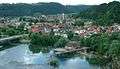 Bosanska Krupa
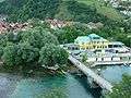 Bosanska Krupa
External links
| Wikimedia Commons has media related to Bosanska Krupa. |
Municipalities of the Una-Sana Canton | ||
|---|---|---|
Coordinates: 44°53′N 16°09′E / 44.883°N 16.150°E