Blackwood, South Australia
| Blackwood Adelaide, South Australia | |||||||||||||
|---|---|---|---|---|---|---|---|---|---|---|---|---|---|
 Blackwood Soldiers' Memorial | |||||||||||||
| Population | |||||||||||||
| Established | 1879 | ||||||||||||
| Postcode(s) | 5051 | ||||||||||||
| LGA(s) | City of Mitcham | ||||||||||||
| State electorate(s) | Davenport | ||||||||||||
| Federal Division(s) | Boothby | ||||||||||||
| |||||||||||||
Blackwood is a south eastern suburb located in the foothills of Adelaide, South Australia. It is part of the local government area of the City of Mitcham.
History
The first use of the name "Blackwood" appears to have been before 1880, in reference to the "Blackwood Inn", a small hotel located where the Belair Hotel now stands. It was probably derived from the Australian Blackwood tree which grows in the area.[3]
Land was first subdivided for housing in 1879, a Methodist church was built in 1881, and the Blackwood railway station opened in 1883.[4] Belair Post Office opened on 3 April 1859 and was renamed Blackwood in 1881, when the Belair office was moved some distance away.[5]
Places of interest
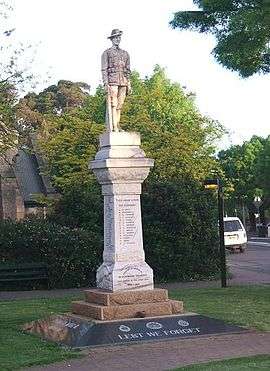
Blackwood Soldiers' Memorial was erected in 1921 in the most prominent place in Blackwood: the five-ways roundabout. It is a place of Local Heritage, listed for being "a notable landmark in the area".
Wittunga Botanic Garden, originally a private property with English gardens established in 1901, is located in Blackwood and features displays of Australian and South African plants.
Blackwood High School and Blackwood Primary School are located nearby in Eden Hills.
Uniting (former Methodist), Anglican, Church of Christ, Baptist, Roman Catholic and Lutheran churches are located in Blackwood, as well as Pentecostal churches including the Hills Christian Family Centre and Frontier Christian centre.
Since the late nineteenth century Main Road Blackwood and surrounding areas have formed a vibrant and diverse food and retail centre.


Transport
Blackwood railway station is a transport hub with buses to Adelaide and the outer Southern suburbs, and trains to Adelaide and Belair.
Residents
The suburbs of Blackwood, Glenalta and Craigburn Farm had a combined population of 6,379 in 2,596 households in 2001.[6]
Norman Tindale, an anthropologist, archaeologist and entomologist, lived in his Blackwood residence "Kurlge" from 1955 to 1969.
The hip hop group the Hilltop Hoods and country singer Beccy Cole (whose song Blackwood Hill references the suburb) [7] are from the area. Award-winning screen composer and filmmaker Milton Trott grew up in Blackwood. Independent Hip-Hop artist Allday also grew up in Blackwood.
Politics
Blackwood is in the state electorate of Davenport, represented in the South Australian House of Assembly by Liberal MP Sam Duluk and in the federal electorate of Boothby, represented in the Australian House of Representatives by Liberal MP Andrew Southcott. Blackwood has a relatively high vote for the Greens when compared to the rest of its electorate and state.[8]
Notes
- ↑ Australian Bureau of Statistics (31 October 2012). "Blackwood (State Suburb)". 2011 Census QuickStats. Retrieved 16 February 2015.
- ↑ Australian Bureau of Statistics (25 October 2007). "Blackwood (State Suburb)". 2006 Census QuickStats. Retrieved 19 July 2010.
- ↑ "The Manning Index of South Australian History - Blackwood". State Library, South Australia. Retrieved 9 July 2008.
- ↑ "History of Blackwood". Blackwood Business Network. Archived from the original on 19 July 2008. Retrieved 12 July 2008.
- ↑ Premier Postal History. "Post Office List". Premier Postal Auctions. Retrieved 26 May 2011.
- ↑ "Community Profile". City of Mitcham. Retrieved 12 July 2008.
- ↑ "Beccy Cole". Postcards SA. Retrieved 12 July 2008.
- ↑ http://results.aec.gov.au/13745/Website/HousePollingPlaceFirstPrefs-13745-6862.htm
External links
- City of Mitcham
- Blackwood High School
- All Hallows' Anglican Church
- Blackwood Hills Baptist
- Blackwood Fitness Centre
| Wikimedia Commons has media related to Blackwood, South Australia. |
Coordinates: 35°01′00″S 138°36′00″E / 35.016667°S 138.600°E