Bjärred
| Bjärred | |
|---|---|
|
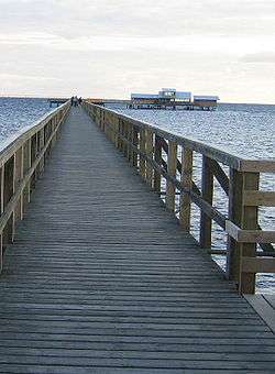
The long jetty in Bjärred | |
 Bjärred  Bjärred | |
| Coordinates: 55°43′N 13°01′E / 55.717°N 13.017°ECoordinates: 55°43′N 13°01′E / 55.717°N 13.017°E | |
| Country | Sweden |
| Province | Skåne |
| County | Skåne County |
| Municipality | Lomma Municipality |
| Area[1] | |
| • Total | 4.79 km2 (1.85 sq mi) |
| Population (31 December 2010)[1] | |
| • Total | 9,542 |
| • Density | 1,992/km2 (5,160/sq mi) |
| Time zone | CET (UTC+1) |
| • Summer (DST) | CEST (UTC+2) |
Bjärred (Swedish: [²bjærːɛd]) is a coastal locality situated in Lomma Municipality, Skåne County, Sweden. It is situated about 20 km north of Malmö, 10 km west of Lund and 5 km north of Lomma village. With 9,542 inhabitants in 2010, it is the second largest locality in Lomma Municipality and accounts for around 44% of its inhabitants.[1] Bjärred largely serves as a suburb of Malmö and Lund.
Among the sights in the town is the open-air swimming-baths, situated 500 meters out on the jetty Långa bryggan.
History
The name Bjärred is thought to come from the Swedish word bjerg, which means height or hill, and may refer to the height at which the settlement appears when viewed from the sea.
The town grew up as a seaside resort for the nearby city of Lund during the 1800s. The construction of an 11-km long railway between Lund and Bjärred began in 1899, and the railway opened for traffic on July 27, 1901. The railway was electrified in 1916, however, it did not prove comercailly succcesful and closed on June 15, 1939, with the rails being removed in 1940.
The population of Bjärred has grown strongly since the mid-1900s, from 864 residents in 1960 to 9542 residents in 2010.[2]
Geography
The settlement can be divided into four areas: Löddesnäs in the north-west, Borgeby in the north, Centrum in the central part of the town and Gamla Bjärred and Haboljung in the south. A large yard named Bjerehof within the settlement has given its name to the eponymous dwelling area in central Bjärred, along with a school and sports hall. What is now the central part of Bjärred was formally Högsäters orchard, founded by Eric Jungquist in the beginning of the 1920s.
Along the beach in Löddesnäs in north Bjärred there is a natrure reserve whose main feature is the 10-15 m high wall, Littorinavallen, which runs parallel to the beach. Above the wall in an meadow named Gyllins meadow, after the owner of a large part of Bjärred in the 1900s. The river Lödde å runs into the Öresund north of Bjärred, where there is also a birdwatching tower.
The village has a shallow beach on the Öresund, with bathing jetty which, at 524 m, is one of the longest in Sweden. During 2004 an outdoor baths opened at the end of the jetty, which also houses a restaurant.[3]

Notable natives
- Patrik Andersson, former football player in the Sweden national football team
- Daniel Andersson, football player in the Sweden national football team
- Andreas Johnson, singer
- Henrik Stenson, golfpro
References
- 1 2 3 "Tätorternas landareal, folkmängd och invånare per km2 2005 och 2010" (in Swedish). Statistics Sweden. 14 December 2011. Archived from the original on 10 January 2012. Retrieved 10 January 2012.
- ↑ "Statistiska centralbyrån - Folkmängd i tätorter 1960-2005" (PDF). Archived from the original (PDF) on 2011-06-23. Retrieved 13 December 2010.
- ↑ "History of Bjärred open-air baths (in Swedish)".
This article contains content translated from the Swedish Wikipedia article at sv:Bjärred.
External links
![]() Media related to Bjärred at Wikimedia Commons
Media related to Bjärred at Wikimedia Commons