Berrow, Somerset
| Berrow | |
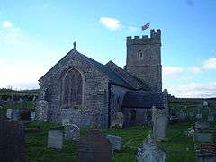 St Mary's church |
|
 Berrow |
|
| Population | 1,534 [1] |
|---|---|
| OS grid reference | ST295525 |
| District | Sedgemoor |
| Shire county | Somerset |
| Region | South West |
| Country | England |
| Sovereign state | United Kingdom |
| Post town | BURNHAM-ON-SEA |
| Postcode district | TA8 |
| Dialling code | 01278 |
| Police | Avon and Somerset |
| Fire | Devon and Somerset |
| Ambulance | South Western |
| EU Parliament | South West England |
Coordinates: 51°16′01″N 3°00′43″W / 51.267°N 3.012°W
Berrow is a village and civil parish in the Sedgemoor district of Somerset, England. According to the 2011 census it had a population of 1,534.[1]
History
Berrow was part of the hundred of Brent-cum-Wrington.[2]
Governance
The parish council has responsibility for local issues, including setting an annual precept (local rate) to cover the council’s operating costs and producing annual accounts for public scrutiny. The parish council evaluates local planning applications and works with the local police, district council officers, and neighbourhood watch groups on matters of crime, security, and traffic. The parish council's role also includes initiating projects for the maintenance and repair of parish facilities, as well as consulting with the district council on the maintenance, repair, and improvement of highways, drainage, footpaths, public transport, and street cleaning. Conservation matters (including trees and listed buildings) and environmental issues are also the responsibility of the council.
The village falls within the Non-metropolitan district of Sedgemoor, which was formed on 1 April 1974 under the Local Government Act 1972, having previously been part of Axbridge Rural District,[3] which is responsible for local planning and building control, local roads, council housing, environmental health, markets and fairs, refuse collection and recycling, cemeteries and crematoria, leisure services, parks, and tourism.
Somerset County Council is responsible for running the largest and most expensive local services such as education, social services, libraries, main roads, public transport, policing and fire services, trading standards, waste disposal and strategic planning.
An electoral ward of the same name exists. Although Berrow is the most populous area the ward stretches north along the coast to Brean. The total population of this ward taken from the 2011 census was 2,169.[4]
It is also part of the a county constituency represented in the House of Commons of the Parliament of the United Kingdom. It elects one Member of Parliament (MP) by the first past the post system of election, and part of the South West England constituency of the European Parliament which elects seven MEPs using the d'Hondt method of party-list proportional representation.
Church
The Church of St Mary dates from the 13th century and was restored in the 19th. The tower contains a bell dating from 1801 and made by Thomas and James Bilbie of the Bilbie family.[5] It has been designated by English Heritage as a grade I listed building.[6]
Beach and dunes
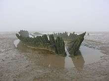
Berrow beach was awarded the Blue flag rural beach award in 2005. The beach is home to the shipwreck of the Norwegian barque SS Nornen, which ran aground on 3 March 1897.[7] In July 2003, Sedgemoor District Council threatened to remove the wreck from the beach fearing it could be held liable if any jet-skiers were to hit the wreck while submerged at high tide.[8]
Berrow Dunes, west of the village, has a golf course, and is a noted site for various unusual plants, including a strong colony of lizard orchids. A 200 hectare (494 acre) area was designated in 1952 as a Site of Special Scientific Interest.[9]
Berrow Marsh, contained within the dunes between the village and the beach, is a mixture of reedbed and salt marsh. Birds found here include many wetland species such as reed and sedge warbler and in winter occasional jack snipe amongst large numbers of common snipe.
Notable people
- Charles Brooke, Rajah of Sarawak born in the vicarage in 1829
References
- 1 2 "Statistics for Wards, LSOAs and Parishes — SUMMARY Profiles" (Excel). Somerset Intelligence. Retrieved 4 January 2014.
- ↑ "Militia in the Brent-cum-Wrington Hundred". Wrington Somerset. Retrieved 12 September 2011.
- ↑ "Axbridge RD". A vision of Britain Through Time. University of Portsmouth. Retrieved 4 January 2014.
- ↑ "ward population 2011.Retrieved 5 March 2015".
- ↑ Moore, James; Rice, Roy; Hucker, Ernest (1995). Bilbie and the Chew Valley clock makers. The authors. ISBN 0-9526702-0-8.
- ↑ "Church of St Mary". Images of England. Retrieved 5 October 2007.
- ↑ "The Berrow Ship Wreck". Burnham-on-Sea website. Retrieved 11 October 2007.
- ↑ "Shipwreck could stay on beach". BBC News. 8 October 2003. Retrieved 11 October 2007.
- ↑ "Berrow Dunes" (PDF). Archived from the original (PDF) on 13 October 2006. Retrieved 6 August 2006.
External links
![]() Media related to Berrow, Somerset at Wikimedia Commons
Media related to Berrow, Somerset at Wikimedia Commons

