Beaulieu, Minnesota
For other uses, see Beaulieu.
| Beaulieu, Minnesota | |
|---|---|
| Census-designated place | |
 Beaulieu, Minnesota | |
| Coordinates: 47°20′08″N 95°48′16″W / 47.33556°N 95.80444°WCoordinates: 47°20′08″N 95°48′16″W / 47.33556°N 95.80444°W | |
| Country | United States |
| State | Minnesota |
| County | Mahnomen |
| Area[1] | |
| • Total | 3.894 sq mi (10.09 km2) |
| • Land | 3.866 sq mi (10.01 km2) |
| • Water | 0.028 sq mi (0.07 km2) |
| Elevation | 1,293 ft (394 m) |
| Population (2010)[2] | |
| • Total | 48 |
| • Density | 12/sq mi (4.8/km2) |
| Time zone | Central (CST) (UTC-6) |
| • Summer (DST) | CDT (UTC-5) |
| Area code(s) | 218 |
| GNIS feature ID | 639799[3] |
Beaulieu is a census-designated place and unincorporated community in Beaulieu and Chief Townships, Mahnomen County, Minnesota, United States. Its population was 48 as of the 2010 census.[2]
History
A post office called Beaulieu was established in 1891, and remained in operation until 1960.[4] John Beaulieu, the postmaster, gave the community its name.[5]
References
- ↑ "US Gazetteer files: 2010, 2000, and 1990". United States Census Bureau. 2011-02-12. Retrieved 2011-04-23.
- 1 2 "American FactFinder". United States Census Bureau. Archived from the original on 2013-09-11. Retrieved 2011-05-14.
- ↑ "Beaulieu". Geographic Names Information System. United States Geological Survey.
- ↑ "County". Jim Forte Postal History. Retrieved 20 July 2015.
- ↑ Upham, Warren (1920). Minnesota Geographic Names: Their Origin and Historic Significance. Minnesota Historical Society. p. 323.
Municipalities and communities of Mahnomen County, Minnesota, United States | ||
|---|---|---|
| Cities | 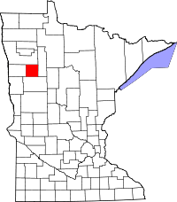 | |
| Townships | ||
| CDPs | ||
| Unincorporated community | ||
| Indian reservations | ||
| Footnotes | ‡This populated place also has portions in an adjacent county or counties | |
This article is issued from Wikipedia - version of the 10/29/2016. The text is available under the Creative Commons Attribution/Share Alike but additional terms may apply for the media files.