Dhungad
| Dhungad ढुङगढ | |
|---|---|
| Village development committee | |
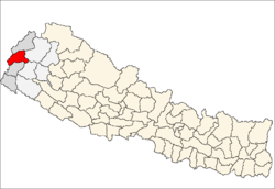
 Dhungad Location in Nepal | |
| Coordinates: 29°23′N 80°49′E / 29.38°N 80.81°ECoordinates: 29°23′N 80°49′E / 29.38°N 80.81°E | |
| Country | Nepal |
| Zone | Mahakali Zone |
| District | Baitadi District |
| Population | |
| • Religions | Hindu |
| Time zone | Nepal Time (UTC+5:45) |
Dhungad is a village development committee in Baitadi District in the Mahakali Zone of western Nepal which is located in the eastern part from headquarter of Baitadi district, this is the small village which is crossed by Seti river. there are living so many casts people, which are chettry, under chettry (Dhami, Saud, Khdayat, Thapa, Rokaya), Barahaman under cast (Awasthi), Thakuri, and Dalit community like B.K., Nepali, Chunara, etc. in this village, there are no other religion people are living only Hindu people are living . there are totally around six school. in which, two school are higher secondary and other are primary. there is no transportation to reach up to there it takes four hour trekking from nearest place ghovghat. Here most of the people are unemployed and they rely on ancient farming. Most people would go to India to earn money in winter after harvest.[1]
References
- ↑ "Nepal Census 2001". Nepal's Village Development Committees. Digital Himalaya. Retrieved 2008-08-26.