Augusto Severo International Airport
| Augusto Severo International Airport Aeroporto Internacional Augusto Severo | |||||||||||||||||||
|---|---|---|---|---|---|---|---|---|---|---|---|---|---|---|---|---|---|---|---|
 | |||||||||||||||||||
|
IATA: | |||||||||||||||||||
| Summary | |||||||||||||||||||
| Airport type | Public/Military | ||||||||||||||||||
| Serves | Natal | ||||||||||||||||||
| Location | Parnamirim, Brazil | ||||||||||||||||||
| Elevation AMSL | 51 m / 167 ft | ||||||||||||||||||
| Coordinates | 05°54′30″S 035°14′57″W / 5.90833°S 35.24917°WCoordinates: 05°54′30″S 035°14′57″W / 5.90833°S 35.24917°W | ||||||||||||||||||
| Website | Infraero SBNT | ||||||||||||||||||
| Map | |||||||||||||||||||
 SBNT Location in Brazil | |||||||||||||||||||
| Runways | |||||||||||||||||||
| |||||||||||||||||||
| Statistics (2013) | |||||||||||||||||||
| |||||||||||||||||||
|
Statistics: Infraero[1] Sources: Airport Website,[2] ANAC[3] *IATA code NAT has been transferred to Gov. Aluízio Alves International Airport | |||||||||||||||||||
Augusto Severo International Airport (Portuguese: Aeroporto Internacional Augusto Severo) (IATA: NAT, ICAO: SBNT), formerly called Parnamirim Airport, was the airport that served Natal, Brazil, located in the adjoining municipality of Parnamirim.
On May 31, 2014 all domestic and international flights moved to Gov. Aluízio Alves International Airport and Augusto Severo was closed to civil aviation.[4][5]
Some of its facilities were shared with the Natal Air Force Base of the Brazilian Air Force. Since November 24, 1951 the airport is named after the aviator Augusto Severo de Albuquerque Maranhão (1864-1902).[6]
History
Before World War II Air France operated a mail service with flying boats and landplanes across the Atlantic from Dakar which routed via Natal: Parnamirim was a combination land and marine airport also used by Pan American World Airways and Panair do Brasil flying boats. In 1940 and 1941 the Italian Airline L.A.T.I. operated a weekly landplane service from Rome to Rio de Janeiro via Recife (mainly southbound) and Natal(mainly northbound) using Savoia-Marchetti tri-motor landplanes until the aircraft were impounded and the service stopped as a result of the intervention of the British secret services in the Americas around the time of the Attack on Pearl Harbor.
The airport gained an important role during World War II as a strategic base for aircraft flying between South America and West Africa. Particularly between 1943 and 1945, this facility was used jointly by the Brazilian Air Force, United States Army, United States Navy, the Royal Air Force, and commercial airlines. The maintenance and security installations were made by the U.S. Army in the South Atlantic (USAFSA).
On March 31, 1980, the Ministry of Aeronautics transferred to Infraero the task of managing the airport. On the same date major renovations were completed.
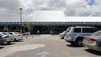
In 2000, the present passenger terminal was built. The terminal is 11,560 m², has 4 jetways, and is capable of handling 1.5 million passengers annually. There are 500 parking places.
On 31 August 2009 Infraero unveiled an ambitious BRL5.3 billion (USD2.8 billion; EUR2.0 billion) investment plan to renovate and upgrade airports of ten cities focusing on the preparations for the 2014 FIFA World Cup which will be held in Brazil. At the occasion it was announced that even though Natal is one of the venue cities, the plan excluded its airport because renovations had been recently completed and Infraero considered the airport fit to handle the forthcoming increase in traffic.[7]
Due to the fact that the capacity of the airport does not meet the present demand of passengers, the brand-new Greater Natal International Airport was built at São Gonçalo do Amarante. On May 31, 2014, all domestic flights were moved to the new facility. International flights moved a few days later.[8] The facilities of Augusto Severo are now used only by Natal Air Force Base.
The following airlines served the airport at the time of closure: Arkefly, Avianca Brazil, Azul Brazilian Airlines, Gol Airlines, TAM Airlines, and TAP Portugal.
Accidents and incidents
- 11 June 1947: Flota Aérea Mercante Argentina, an Avro 691 Lancastrian registration LV-ACS flying from Buenos Aires to Natal struck a post on landing and caught fire. Of the 18 passengers and crew, 13 survived.[9]
Access
The airport is located 18 km (11 mi) from downtown Natal.
See also
References
![]() This article incorporates public domain material from the Air Force Historical Research Agency website http://www.afhra.af.mil/.
This article incorporates public domain material from the Air Force Historical Research Agency website http://www.afhra.af.mil/.
- ↑ "Movimento operacional da rede Infraero de janeiro a dezembro de 2013" (PDF) (in Portuguese). Infraero. 4 February 2014. Retrieved 14 June 2014.
- ↑ "Airport Official Website" (in Portuguese). Infraero.
- ↑ "Lista de aeródromos públicos" (in Portuguese). ANAC.
- ↑ Aeroporto Augusto Severo é desativado sem cerimônias em Parnamirim
- ↑ No RN, Receita Federal libera voos internacionais no novo aeroporto
- ↑ "Lei n˚1.374A, de 24 de novembro de 1951" (in Portuguese). Lei Direto. November 24, 1951. Archived from the original on 7 June 2011. Retrieved May 15, 2011.
- ↑ "Infraero vai gastar R$5 bi em reforma de aeroportos". Valor Econômico. August 31, 2009. Retrieved October 9, 2009.
- ↑ "Veja fotos do aeroporto de São Gonçalo do Amarante" (in Portuguese). Panrotas. June 4, 2014. Retrieved June 4, 2014.
- ↑ "Accident description LV-ACS". Aviation Safety Network. Archived from the original on November 3, 2012. Retrieved May 9, 2011.
External links
| Wikimedia Commons has media related to Augusto Severo International Airport. |
- Airport information for SBNT at World Aero Data. Data current as of October 2006.Source: DAFIF.
- Airport information for SBNT at Great Circle Mapper. Source: DAFIF (effective October 2006).
- Current weather for SBNT at NOAA/NWS
- Accident history for NAT at Aviation Safety Network
- Augusto Severo International Airport Photo Archive at airliners.net
- LIFE photo L.A.T.I Savoia-Marchetti SM.82 arrives while field being improved for U.S.
- LIFE photo DC-2/DC-3 ferrying by PAA to British by old Air France hangar Parnamarim
- LIFE photo DC-2/DC-3 ferrying by PAA to British by L.A.T.I hangars Parnamarim
- LIFE photo Pan American Boeing 314 Clipper at Natal Marine terminal