Argilliers
| Argilliers | ||
|---|---|---|
|
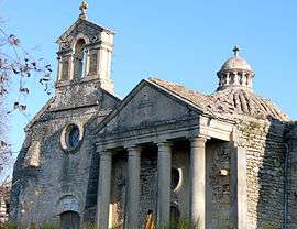
The chapel of the Château de Castille in Argilliers | ||
| ||
 Argilliers | ||
|
Location within Occitanie region  Argilliers | ||
| Coordinates: 43°58′50″N 4°29′45″E / 43.9806°N 4.4958°ECoordinates: 43°58′50″N 4°29′45″E / 43.9806°N 4.4958°E | ||
| Country | France | |
| Region | Occitanie | |
| Department | Gard | |
| Arrondissement | Nîmes | |
| Canton | Remoulins | |
| Intercommunality | Pont du Gard | |
| Government | ||
| • Mayor (2001–2008) | Daniel Roux | |
| Area1 | 6.67 km2 (2.58 sq mi) | |
| Population (2008)2 | 331 | |
| • Density | 50/km2 (130/sq mi) | |
| Time zone | CET (UTC+1) | |
| • Summer (DST) | CEST (UTC+2) | |
| INSEE/Postal code | 30013 / 30210 | |
| Elevation |
37–200 m (121–656 ft) (avg. 54 m or 177 ft) | |
|
1 French Land Register data, which excludes lakes, ponds, glaciers > 1 km² (0.386 sq mi or 247 acres) and river estuaries. 2 Population without double counting: residents of multiple communes (e.g., students and military personnel) only counted once. | ||
.svg.png)
Argilliers is a commune in the Gard department in southern France.
Population
| Historical population | ||
|---|---|---|
| Year | Pop. | ±% |
| 1962 | 69 | — |
| 1968 | 74 | +7.2% |
| 1975 | 76 | +2.7% |
| 1982 | 96 | +26.3% |
| 1990 | 120 | +25.0% |
| 1999 | 193 | +60.8% |
| 2008 | 331 | +71.5% |
See also
References
| Wikimedia Commons has media related to Argilliers. |
This article is issued from Wikipedia - version of the 11/6/2016. The text is available under the Creative Commons Attribution/Share Alike but additional terms may apply for the media files.