Air Line State Park Trail
| Air Line State Park Trail | |
| Connecticut State Park | |
 Air Line Trail northeast of Black Spruce Pond in Hampton, CT (Pine Acres Lake View Trail intersection near Goodwin Conservation Center) | |
| Country | |
|---|---|
| State | |
| Counties | Middlesex, New London, Tolland, Windham |
| Towns | East Hampton, Colchester, Hebron, Columbia, Lebanon, Windham, Chaplin, Hampton, Pomfret, Putnam, Thompson |
| Area | 40 acres (16 ha) |
| Established | 1969 |
| Management | Connecticut Department of Energy and Environmental Protection |
| Website: Air Line State Park Trail | |
The Air Line State Park Trail is a rail trail and linear state park located in Connecticut. The trail is divided into sections designated South (23 miles: East Hampton to Windham), North (21 miles: Windham to Putnam), and the Thompson addition (6.6 miles: Thompson to the Massachusetts state line).[1] An additional 3.6 mile spur to Colchester is sometimes designated as part of the Air Line trail.
The United States Department of the Interior recognized the southern section of the Air Line State Park Trail as a national recreation trail in 2002.[2]
History
Air Line
Envisioned as a high speed passenger railroad line from New York to Boston, the New Haven, Middletown and Willimantic Railroad (NHM&W) got its name from the towering iron viaducts constructed to create a level track bed suitable for rapid travel. Opened in 1873 as part of the Boston, Hartford and Erie Railroad (BH&E) system, it ran from New Haven northeast via Middletown to the BH&E at Willimantic. The BH&E went bankrupt that same year, becoming the New York and New England Railroad (NY&NE), but the NHM&W stayed separate, failing in 1875. It was reorganized as the Boston and New York Air-Line Railroad and was operated by the New Haven from 1879, being leased on October 1, 1882. Part of this line (the NY&NE Blackstone division to Franklin via Norwood and Walpole) still survives as the Franklin Branch of the MBTA/MBCR.
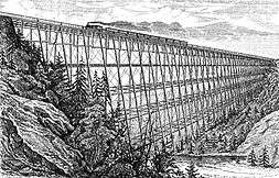
In Connecticut, part of the line from New Haven (Air Line Jct) to Middletown and Portland, Connecticut survives as part of the Providence and Worcester Railroad. In Willimantic, the Connecticut Eastern Railroad Museum has reconstructed the original roundhouse and restored the turntable pit (with a replacement for the original turntable), as well as some original NY&NE and NH buildings. In between East Hampton, Connecticut and the Massachusetts state line, most of the abandoned rail corridor has been converted as a rail trail known as the Air Line Trail State Park. Notable features of the line are the Rapallo Viaduct and the Lyman Viaduct in East Hampton and Colchester, Connecticut, which are two of the longest rail viaducts in the U.S.[3]
Trail development
The abandoned rail corridor between East Hampton and the Massachusetts state line was acquired by the Connecticut State Park System with the section from Route 66 in Windham to US Route 44 in Pomfret opening to the public in 1969 as a bridle trail. In 1976, the trail designation was extended north to Town Farm Road in Putnam. The southern section from East Hampton to Willimantic was opened as a trail in 1986. The Thompson section was opened in 1992. The bridge over the Willamantic River to Bridge St. was opened in 2015.
Air Line State Park Trail is divided into three sections:
- South section (from Main Street in East Hampton to Bridge Street)
- North section (from Tuckie Road in Windham to Town Farm Road in Putnam)
- Thompson section (from Route 12 in Thompson to the MA state line)
The North section of the trail from Windham to Putnam is part of the East Coast Greenway, which will stretch from Florida to Maine.
The South and North sections are connected by the Veterans Greenway, a short town-owned rail trail on the northeast side of Willimantic, which is partially incorporated into the North section itself. The connection is not complete, as and no trail connection has yet to be made through downtown Willimantic from the bridge to the Veterans Greenway. However a street connection is available joining the two sections by going onto Bridge Street for 250 feet, then turning right onto Main Street for 0.5 miles then turning left on Jackson St. for 150 feet then turning right on Union St. 50 feet.
Southern extensions
The trail as originally built ended next to a cranberry bog at Smith Street, east of the village center of East Hampton. The right of way remained intact and unused as far as the end of active track in Portland; some sections were used for unofficial trails with poor trail surface and frequent washouts.[4]
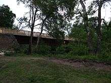
In 1999, a bridge over Muddy Gutter Brook west of downtown East Hampton was designed and built by cadets of the United States Coast Guard Academy under the supervision of William O'Neill, an adjunct professor of engineering at the academy and former state governor. Due to confusion as to which state agency had ownership of the stretch of land, the bridge was built without the necessary permissions; it was almost demolished, but allowed to remain due to a lease agreement with the town.[5] On November 1, 2002, the state DEEP acquired an additional section of railbed in East Hampton from ConnDOT; however, the trail was not actually improved over the section.[6]
In 2011, a 0.5-mile (0.80 km) extension from Smith Street to Watrous Street was completed. A further 0.1-mile (0.16 km) section (including a bridge over the Pocotopaug Creek) was completed in June 2012, bringing the trail to Main Street in downtown East Hampton. During construction, the original railroad bridge was found to have been buried in the embankment next to the right of way, forcing design changes to the trail.[7]
Around that time, East Hampton and Portland began planning to extend the trail to downtown Portland, which would additionally provide a connection to Middletown over the Arrigoni Bridge.[8] In January 2015, East Hampton received a $400,000 grant for Phase I, running 1.7 miles (2.7 km) from Main Street to Alden Crossing; that section is expected to open in 2016.[9][10] A second $538,000 state grant, awarded in March 2016, will fund the 1.5-mile (2.4 km) Phase II from Aldens Crossing to the town line at Depot Hill Road.[11]
Unlike the rest of the trail, the right-of-way in Portland is owned by Eversource Energy (except for a short stub near the bridge over the Connecticut River, which is owned by ConnDOT and used by the Providence and Worcester Railroad for freight service).[6][12] Phase I in Portland will be from the town line to the YCMA Camp Ingersoll, a distance of 2.3 miles (3.7 km). In December 2015, the town approved an agreement with Eversource to allow the construction of a recreational trail on their property; a formal signing took place on January 20, 2016.[4] On March 2, 2016, town voters approved the $172,000 acquisition of a 22-acre (8.9 ha) former quarry to serve as the trailhead; this served as the 20% local match for potential state funding. Later that month, the extension was allocated $686,000 in the same round of grants that funded the East Hampton Phase II. The section is expected to open around April 2017.[11]
Further phases in Portland are planned but not yet funded. Phase II will reach downtown Portland and the Arrigoni bridge, largely over the original rail route but with some deviations parallel to roads.[12] It may also include a trail parallel to the active P&W tracks in Portland, and the purchase of the former train station.[4] Phase III will attempt to create a trail north parallel to the Connecticut River to reach Riverfront Park, the fairgrounds, and ultimately Glastonbury.[4]
South section
Trail description
This section of the trail has been completed. It has a smooth, hard-packed stone dust surface, benches for resting at more scenic locations, and bike racks. Brand new bridges constructed by cadets from the US Coast Guard Academy carry the trail across the Blackledge and Jeremy Rivers and Judd Brook. This section crosses the Rapallo and Lyman Viaducts, massive fills that carried the railroad and now trail across wide valleys. They provide spectacular views, especially in the fall. There is a short (less than 1⁄4 mile (400 m)) on-road detour necessary where the Route 2 expressway blocks the railroad bed.
Willimantic River to Bridge St. (CT 32)
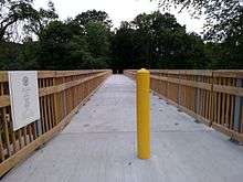
This section has a wooden plank crossing over the Willimantic River, using the old bridge as support, then shortly after that it becomes pavement and intersects with the end of the Hop River Trail and has a info sign describing the history of both of the trails. Then it takes a s-turn next to the Eastern Connecticut Railroad History Museum. Then the trail follows the driveway of the building leading up to the trailhead, just 900 ft. away from Bridge St. This section can be very loud at times due to being less than 100 ft. away from the Providence and Worcester Railroad, an active freight railroad with a stop in Willimantic.
Access points
The trail crosses the following roads, providing access:
North section
Trail description
Though open to the public for its entire length, different segments of the trail are in different stages of development. Some sections are complete and have a finished, stone-dust surface and signage. Other sections have been cleared and had drainage work done, but still have a somewhat rough, unfinished surface that is not suitable for road bikes. Other parts are totally undeveloped and overgrown.
There are no major obstructions of the North section of the trail in the form of missing or unsafe bridges. Though some parts of the trail may be undeveloped, this area does not have the many river crossings of the southern section.
The trail continues west of Route 66 as the Veterans Greenway, a town-owned bikeway that leads to downtown Willimantic.
Route 66, Windham to South Brook Road, Hampton
This section has seen many upgrades in recent years. The section's first 1⁄4 mile (400 m) was paved as part of the US 6/Route 66 interchange reconstruction project. The state and the towns of Windham and Chaplin cleared, graded, installed signage and put down a smooth stone-dust surface on this section of the trail. This included the construction of a trail bridge over Boulevard Road.

South Brook Road, Hampton to Lewis Road, Hampton
This section was cleared and graded by the National Guard in the mid-1990s. The surface was not finished and is still rough in sections and there are drainage issues in areas that sometimes flood the trail. There has not been much maintenance done on the trail in the last few years, so even the areas that were cleared have become somewhat grown in. Still, the trail is passable for hikers, equestrians and mountain bikers. The town of Hampton and the DEEP have plans to add signage and finish the surface of the trail with stone dust. This work has not yet been started. An abandoned overpass which formerly carried Parker Road over the line collapsed in May 2016; the trail section was briefly closed while during cleanup.
Lewis Road, Hampton to Wrights Crossing Road, Pomfret
This section is under construction by the DEEP, DOT and town of Pomfret. The stretch from Lewis Road to Covell Road is currently being worked on to improve drainage and finish the surface. The trail is completed between Covell Road and Route 169, with smooth stone-dust surface. The section from Route 169 to Wrights Crossing Road is essentially complete, with some drainage improvements planned.
Wrights Crossing Road, Pomfret to Kennedy Drive, Putnam
This section of trail is completely undeveloped. It has not been cleared and is overgrown, with a rough surface, tree falls, and several wet areas with drainage problems. It is necessary to climb embankments to cross some roads where former bridges have been filled in. It is not really passable, and must be done on foot if attempted. The DEEP and the towns of Pomfret and Putnam have plans to clear and improve this section as part of the next phase of trail improvements.
Access points
The trail crosses the following roads, providing access:
Thompson section
Trail description
Entire Section: Major work is underway to upgrade this section of trail . The rails and ties have been removed, and the surface of the trail is being graded and having drainage improved. Surface of the trail when complete will be hard packed dirt and gravel. The trail is generally clear of major obstructions, save for one missing bridge over a creek that requires a short detour on a parallel single track trail. New parking areas with signage and information kiosks have been constructed where the trail crosses East Thompson Road, Sand Dam Road, Lowell Davis Road, and the trail terminus at Route 12. Work still underway includes improvements of the Route 193 crossing .
Access points
The trail crosses the following roads, providing access:
| County | Town | Street | Coordinates | |
|---|---|---|---|---|
| Windham | Thompson | Terminus (south of Thompson center) | 41°56′51″N 71°53′06″W / 41.9475°N 71.8851°W | |
| Bridge over ramps - no connection | 41°57′17″N 71°52′51″W / 41.9547°N 71.8809°W | |||
| Overpass - no connection | 41°58′01″N 71°52′26″W / 41.9669°N 71.8740°W | |||
| Sunset Hill Road | 41°58′35″N 71°51′57″W / 41.9764°N 71.8658°W | |||
| Lowell Davis Road | 41°59′05″N 71°51′24″W / 41.9846°N 71.8566°W | |||
| Overpass - no connection | 41°59′14″N 71°51′11″W / 41.9873°N 71.8531°W | |||
| Overpass - no connection (north of Thompson center) | 41°59′34″N 71°50′38″W / 41.9929°N 71.8438°W | |||
| Sand Dam Road | 42°00′16″N 71°49′12″W / 42.0045°N 71.8201°W | |||
| East Thompson Road | Connection with Southern New England Trunkline Trai | 42°00′32″N 71°48′33″W / 42.0089°N 71.8091°W |
The trail continues east and north into Massachusetts, at Douglas as the Southern New England Trunkline Trail, part of the Massachusetts State Park System. Massachusetts has improved access at trailheads and road crossings, but many bridges are absent and the trail is not continuous. Sections of the trail continue to Franklin, Massachusetts.
Colchester Spur
Trail description
The 3.6-mile (5.8 km) spur to Colchester consists of the same hard-packed gravel as the rest of the South section. The Route 85 crossing is at a marked crosswalk, while the two other crossings are unmarked over minor local roads. The trail terminates just east of downtown Colchester at the former depot and freight house.[14]
Access points
The trail crosses the following roads, providing access:
| County | Town | Street | Coordinates | |
|---|---|---|---|---|
| Tolland | Hebron | 41°37′11″N 72°20′39″W / 41.6196°N 72.3441°W | ||
| Crouch Road | 41°36′50″N 72°20′34″W / 41.6139°N 72.3428°W | |||
| New London | Colchester | Old Amston Road | 41°35′41″N 72°20′01″W / 41.5947°N 72.3335°W | |
| Terminus | 41°34′46″N 72°19′38″W / 41.5795°N 72.3273°W | |||
References
- ↑ "Air Line State Park Trail". State Parks and Forests. Connecticut Department of Energy and Environmental Protection. Retrieved 2013-02-05.
- ↑ Associated Press (June 11, 2002). "New Recreation Trails Designated in 16 States". The Cincinnati Post (Cincinnati, OH). Retrieved 29 July 2014.
- ↑ Dale Karr, Ronald (1989). Lost Railroads of New England. Branch Line Press. ISBN 0-942147-04-9.
- 1 2 3 4 "Portland Air Line Trail Update: March 2016" (PDF). Air Line Trail Steering Committee, Town of Portland. March 2016.
- ↑ Byron, Ken (May 13, 1999). "Plan Expected to Save Trail Bridge". Hartford Courant. p. B1. (subscription required (help)).
- 1 2 "2013 Connecticut Rail Transportation Ownership and Service" (PDF). Connecticut Department of Transportation. August 2013. Retrieved August 19, 2016.
- ↑ Anusewicz, Joshua (June 29, 2012). "East Hampton Trail Extension Opens This Weekend" (PDF). Rivereast News Bulletin.
- ↑ Marteka, Peter (February 7, 2016). "Portland, Windham Filling Gaps Along The Air Line Trail". Hartford Courant. Retrieved August 19, 2016.
- ↑ "Ziobron Applauds Grant Awarded To Air Line Trail State Park, $400,000.00 in Funds to be used for a Western Extension" (Press release). Connecticut House Republican Office. January 28, 2015.
- ↑ Marteka, Peter (April 25, 2015). "A Soggy Journey Along The Old Air Line Railroad". Hartford Courant. Retrieved August 19, 2016.
- 1 2 Regan, Elizabeth (April 1, 2016). "State Awards $1.3 Million for Air Line Trail in Portland" (PDF). Rivereast News Bulletin.
- 1 2 Shafer, John; Rhodes, Deanna; Haramut, Robert. "Bringing the Air Line Trail to Portland (And Middletown)" (PDF). Town of Portland.
- ↑ Courant, Hartford. "Portland, Windham Filling Gaps Along The Air Line Trail". Retrieved 2016-08-02.
- ↑ "Colchester Spur Trail". Bike It or Hike It. April 2008. Retrieved 23 June 2013.
External links
- Air Line State Park Trail Connecticut Department of Energy and Environmental Protection
- The Air Line Trail: Guide & Map for the Towns of East Hampton, Colchester, Hebron and Lebanon East Hampton Parks & Recreation
- Airline Rail Trail RailsToTrails.us: Bike Trails Created from Abandoned Railroad Lines
- Air Line Rail Trail history and photo resource
