Administrative divisions of Bermuda
 |
| This article is part of a series on the politics and government of Bermuda |
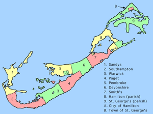
The land area of Bermuda is divided into nine parishes. There are also two defined municipalities, located in the boundaries of two of the parishes.
Parishes
Bermuda has nine "Parishes", originally called "Tribes". Each of the nine parishes with the exception of St. George's covers the same land area, (2.31 square miles / 5.97 km²). The Parishes are not administrative divisions, and have no relationship with Bermuda's electoral districts.
| Parish | Population (2010)[1] |
Population (2000)[1] |
Change (%)[1][1] |
Land area (km²) |
Population density |
|---|---|---|---|---|---|
| Devonshire | 7,332 | 7,307 | +0.3% | 5.97 | 1,228.1/km2 |
| Hamilton | 5,862 | 5,270 | +11.2% | 5.97 | 981.9/km2 |
| Paget | 5,702 | 5,088 | +12.1% | 5.97 | 955.1/km2 |
| Pembroke | 10,610 | 11,306 | −6.2% | 5.97 | 1,777.2/km2 |
| St George's | 6,422 | 5,451 | +17.8% | 6.6 | 973.0/km2 |
| Sandys | 7,655 | 7,275 | +5.2% | 5.97 | 1,282.2/km2 |
| Smith's | 5,406 | 5,658 | −4.5% | 5.97 | 905.5/km2 |
| Southampton | 6,633 | 6,117 | +8.4% | 5.97 | 1,111.1/km2 |
| Warwick | 8,615 | 8,587 | +0.3% | 5.97 | 1,443.0/km2 |
Note on pronunciation:
- The "y" in Sandys is often not pronounced
- The second "w" in Warwick is not pronounced
Municipalities
- Hamilton (City) (1,100)
- St. George's (Town) (1,648)
Whereas the town of St George's is surrounded by St George's Parish, Hamilton Parish and the city of Hamilton are not close to each other geographically.
Saint George's, the larger of the two municipalities, served as Bermuda's capital until 1815 until the newly established Hamilton replaced it.
Villages
Bermuda has two villages (unincorporated urban areas)
- Flatts Village (412)
- Somerset Village (1,000)
References
- 1 2 3 4 "Population and vital statistics" (PDF). Government of Bermuda Department of Statistics. 2000. Retrieved March 28, 2016.
Subdivisions of the Americas | ||
|---|---|---|
| ||
| Sovereign states |
| .svg.png) |
| ||
