Lapse rate
The lapse rate is defined as the rate at which atmospheric temperature decreases with an increase in altitude.[1][2] The terminology arises from the word lapse in the sense of a decrease or decline. While most often applied to Earth's troposphere, the concept can be extended to any gravitationally supported parcel of gas.
Definition
A formal definition from the Glossary of Meteorology[3] is:
- The decrease of an atmospheric variable with height, the variable being temperature unless otherwise specified.
In general, a lapse rate is the negative of the rate of temperature change with altitude change, thus:

where is the lapse rate given in units of temperature divided by units of altitude, T = temperature, and z = altitude.[lower-alpha 1]

Convection and adiabatic expansion
The temperature profile of the atmosphere is a result of an interaction between radiation and convection. Sunlight hits the ground and heats it. The ground then heats the air at the surface. If radiation were the only way to transfer heat from the ground to space, the greenhouse effect of gases in the atmosphere would keep the ground at roughly 333 K (140 °F), and the temperature would decay exponentially with height.[6]
However, when air is hot, it tends to expand, which lowers its density. Thus, hot air tends to rise and transfer heat upward. This is the process of convection. Convection comes to equilibrium when a parcel of air at a given altitude has the same density as the other air at the same elevation.
When a parcel of air expands, it pushes on the air around it, doing work (thermodynamics). Since the parcel does work but gains no heat, it loses internal energy so that its temperature decreases. The process of expanding and contracting without exchanging heat is an adiabatic process. The term adiabatic means that no heat transfer occurs into or out of the parcel. Air has low thermal conductivity, and the bodies of air involved are very large, so transfer of heat by conduction is negligibly small.
The adiabatic process for air has a characteristic temperature-pressure curve, so the process determines the lapse rate. When the air contains little water, this lapse rate is known as the dry adiabatic lapse rate: the rate of temperature decrease is 9.8 °C/km (5.38 °F per 1,000 ft) (3.0 °C/1,000 ft). The reverse occurs for a sinking parcel of air.[7]
Note that only the troposphere (up to approximately 12 kilometres (39,000 ft) of altitude) in the Earth's atmosphere undergoes convection: the stratosphere does not generally convect.[8] However, some exceptionally energetic convection processes -- notably volcanic eruption columns and overshooting tops associated with severe supercell thunderstorms -- may locally and temporarily inject convection through the tropopause and into the stratosphere.
The mathematics of the adiabatic lapse rate can be derived from thermodynamics, which defines an adiabatic process via:

the first law of thermodynamics can be written as

Also since : and : we can show that:


where is the specific heat at constant pressure and is the specific volume.


Assuming an atmosphere in hydrostatic equilibrium:[9]

where g is the standard gravity and is the density. Combining these two equations to eliminate the pressure, one arrives at the result for the dry adiabatic lapse rate (DALR),[10]


Moist adiabatic lapse rate
The presence of water in the atmosphere complicates the process of convection. Water vapor contains latent heat of vaporization. As air rises and cools, it eventually becomes saturated and cannot hold its quantity of water vapor. The water vapor condenses (forming clouds), and releases heat, which changes the lapse rate from dry below the cloud to moist in the cloud.[11] The release of latent heat is an important source of energy in the development of thunderstorms.
The moist adiabatic lapse rate varies strongly with temperature. A typical value is around 5 °C/km (2.7 °F/1,000 ft) (1.5 °C/1,000 ft).[12]
The saturated adiabatic lapse rate is given approximately by:[13]

where: = Wet adiabatic lapse rate, K/m = Earth's gravitational acceleration = 9.8076 m/s2 = Heat of vaporization of water, = 2501000 J/kg = Specific gas constant of dry air = 287 J kg−1 K−1 = Specific gas constant of water vapour = 461.5 J kg−1 K−1 =The dimensionless ratio of the specific gas constant of dry air to the specific gas constant for water vapour = 0.622 = The water vapour pressure of the saturated air = The pressure of the saturated air = The mixing ratio of the mass of water vapour to the mass of dry air[14] = Temperature of the saturated air, K = The specific heat of dry air at constant pressure, = 1003.5 J kg−1 K−1


Environmental lapse rate
The environmental lapse rate (ELR), is the rate of decrease of temperature with altitude in the stationary atmosphere at a given time and location. As an average, the International Civil Aviation Organization (ICAO) defines an international standard atmosphere (ISA) with a temperature lapse rate of 6.49 K/km[15] (3.56 °F or 1.98 °C/1,000 ft) from sea level to 11 km (36,090 ft or 6.8 mi). From 11 km up to 20 km (65,620 ft or 12.4 mi), the constant temperature is −56.5 °C (−69.7 °F), which is the lowest assumed temperature in the ISA. The standard atmosphere contains no moisture. Unlike the idealized ISA, the temperature of the actual atmosphere does not always fall at a uniform rate with height. For example, there can be an inversion layer in which the temperature increases with altitude.
Effect on weather
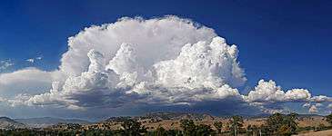
The varying environmental lapse rates throughout the Earth's atmosphere are of critical importance in meteorology, particularly within the troposphere. They are used to determine if the parcel of rising air will rise high enough for its water to condense to form clouds, and, having formed clouds, whether the air will continue to rise and form bigger shower clouds, and whether these clouds will get even bigger and form cumulonimbus clouds (thunder clouds).
As unsaturated air rises, its temperature drops at the dry adiabatic rate. The dew point also drops (as a result of decreasing air pressure) but much more slowly, typically about −2 °C per 1,000 m. If unsaturated air rises far enough, eventually its temperature will reach its dew point, and condensation will begin to form. This altitude is known as the lifting condensation level (LCL) when mechanical lift is present and the convective condensation level (CCL) when mechanical lift is absent, in which case, the parcel must be heated from below to its convective temperature. The cloud base will be somewhere within the layer bounded by these parameters.
The difference between the dry adiabatic lapse rate and the rate at which the dew point drops is around 8 °C per 1,000 m. Given a difference in temperature and dew point readings on the ground, one can easily find the LCL by multiplying the difference by 125 m/°C.
If the environmental lapse rate is less than the moist adiabatic lapse rate, the air is absolutely stable — rising air will cool faster than the surrounding air and lose buoyancy. This often happens in the early morning, when the air near the ground has cooled overnight. Cloud formation in stable air is unlikely.
If the environmental lapse rate is between the moist and dry adiabatic lapse rates, the air is conditionally unstable — an unsaturated parcel of air does not have sufficient buoyancy to rise to the LCL or CCL, and it is stable to weak vertical displacements in either direction. If the parcel is saturated it is unstable and will rise to the LCL or CCL, and either be halted due to an inversion layer of convective inhibition, or if lifting continues, deep, moist convection (DMC) may ensue, as a parcel rises to the level of free convection (LFC), after which it enters the free convective layer (FCL) and usually rises to the equilibrium level (EL).
If the environmental lapse rate is larger than the dry adiabatic lapse rate, it has a superadiabatic lapse rate, the air is absolutely unstable — a parcel of air will gain buoyancy as it rises both below and above the lifting condensation level or convective condensation level. This often happens in the afternoon mainly over land masses. In these conditions, the likelihood of cumulus clouds, showers or even thunderstorms is increased.
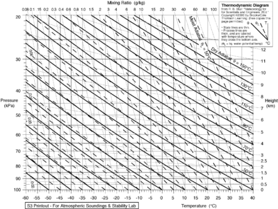
Meteorologists use radiosondes to measure the environmental lapse rate and compare it to the predicted adiabatic lapse rate to forecast the likelihood that air will rise. Charts of the environmental lapse rate are known as thermodynamic diagrams, examples of which include Skew-T log-P diagrams and tephigrams. (See also Thermals).
The difference in moist adiabatic lapse rate and the dry rate is the cause of foehn wind phenomenon (also known as "Chinook winds" in parts of North America). The phenomenon exists because warm moist air rises through orographic lifting up and over the top of a mountain range or large mountain. The temperature decreases with the dry adiabatic lapse rate, until it hits the dew point, where water vapor in the air begins to condense. Above that altitude, the adiabatic lapse rate decreases to the moist adiabatic lapse rate as the air continues to rise. Condensation is also commonly followed by precipitation on the top and windward sides of the mountain. As the air descends on the leeward side, it is warmed by adiabatic compression at the dry adiabatic lapse rate. Thus, the foehn wind at a certain altitude is warmer than the corresponding altitude on the windward side of the mountain range. In addition, because the air has lost much of its original water vapor content, the descending air creates an arid region on the leeward side of the mountain.[16]
See also
Notes
- ↑ Note: In some cases, or can be used to represent the adiabatic lapse rate in order to avoid confusion with other terms symbolized by , such as the specific heat ratio[4] or the psychrometric constant.[5]

References
- ↑ Mark Zachary Jacobson (2005). Fundamentals of Atmospheric Modeling (2nd ed.). Cambridge University Press. ISBN 0-521-83970-X.
- ↑ C. Donald Ahrens (2006). Meteorology Today (8th ed.). Brooks/Cole Publishing. ISBN 0-495-01162-2.
- ↑ Todd S. Glickman (June 2000). Glossary of Meteorology (2nd ed.). American Meteorological Society, Boston. ISBN 1-878220-34-9. (Glossary of Meteorology)
- ↑ Salomons, Erik M. (2001). Computational Atmospheric Acoustics (1st ed.). Kluwer Academic Publishers. ISBN 1-4020-0390-0.
- ↑ Stull, Roland B. (2001). An Introduction to Boundary Layer Meteorology (1st ed.). Kluwer Academic Publishers. ISBN 90-277-2769-4.
- ↑ Goody, Richard M.; Walker, James C.G. (1972). "Atmospheric Temperatures" (PDF). Atmospheres. Prentice-Hall.
- ↑ Danielson, Levin, and Abrams, Meteorology, McGraw Hill, 2003
- ↑ "The stratosphere: overview". UCAR. Retrieved 2016-05-02.
- ↑ Landau and Lifshitz, Fluid Mechanics, Pergamon, 1979
- ↑ Kittel; Kroemer (1980). "6". Thermal Physics. Freeman. problem 11
- ↑ "Dry Adibatic Lapse Rate". tpub.com. Retrieved 2016-05-02.
- ↑ Minder, JR; Mote, PW; Lundquist, JD (2010). "Surface temperature lapse rates over complex terrain: Lessons from the Cascade Mountains". J. Geophys. Res. 115: D14122. Bibcode:2010JGRD..11514122M. doi:10.1029/2009JD013493.
- ↑ "Saturation adiabatic lapse rate". Glossary. American Meteorological Society.
- ↑ "Mixing ratio". Glossary. American Meteorological Society.
- ↑ Manual of the ICAO Standard Atmosphere (extended to 80 kilometres (262 500 feet)) (Third ed.). International Civil Aviation Organization. 1993. ISBN 92-9194-004-6. Doc 7488-CD.
- ↑ Whiteman, C. David (2000). Mountain Meteorology: Fundamentals and Applications. Oxford University Press. ISBN 0-19-513271-8.
Additional reading
- Beychok, Milton R. (2005). Fundamentals Of Stack Gas Dispersion (4th ed.). author-published. ISBN 0-9644588-0-2. www.air-dispersion.com
- R. R. Rogers and M. K. Yau (1989). Short Course in Cloud Physics (3rd ed.). Butterworth-Heinemann. ISBN 0-7506-3215-1.
External links
- Definition, equations and tables of lapse rate from the Planetary Data system.
- National Science Digital Library glossary:
- An introduction to lapse rate calculation from first principles from U. Texas
