1962 Atlantic hurricane season
 | |
| Season summary map | |
| First system formed | August 26, 1962 |
|---|---|
| Last system dissipated | October 22, 1962 |
| Strongest storm1 | Ella – 950 mbar (hPa) (28.05 inHg), 115 mph (185 km/h) (1-minute sustained) |
| Total depressions | 8 |
| Total storms | 5 |
| Hurricanes | 3 |
| Major hurricanes (Cat. 3+) | 1 |
| Total fatalities | 29 overall |
| Total damage | $3.9 million (1962 USD) |
| 1Strongest storm is determined by lowest pressure | |
1960, 1961, 1962, 1963, 1964 | |
The 1962 Atlantic hurricane season was the least active since 1939, with only five named storms. Although the season officially began on June 15, the first storm did not form until August 26. Hurricane Alma brushed the Outer Banks before becoming extratropical southeast of New England, destroying hundreds of boats and producing beneficial rainfall. In late August, Tropical Storm Becky developed unusually far east in the Atlantic Ocean, becoming the easternmost storm on record to recurve to the northeast. Celia followed in the September, forming east of the Lesser Antilles and executing a loop near Bermuda before dissipating. Hurricane Daisy was the costliest of the season, leaving about $1.1 million in damage in New England (1962 USD). The storm dropped the highest rainfall total on record in Maine, and its precipitation caused 22 traffic fatalities. The final hurricane – Ella – was also the strongest, remaining offshore of the eastern United States but causing two deaths.
In addition to the five named storms, there were three non-developing tropical depressions. The first struck Texas in August, causing street flooding and killing three. The second of three formed off the west coast of Florida and flooded widespread areas after 1 in 100 year rainfall. The floods affected 5,000 houses and caused millions in damage. The third of three non-developing storms moved across the Caribbean before striking Nicaragua in October. The season officially ended on November 15.
Season activity
The hurricane season officially began on June 15, 1962. The National Hurricane Center began operations with no new equipment, and the warning agency instead opted to improve with the existing equipment. The agency had access to a system of radars that extended from Brownsville, Texas, to Eastport, Maine, which was set up in 1961. Although satellite imagery technology was available, the system was not fully active to provide daily images of Atlantic hurricanes.[1] The season officially ended on November 15.[2]
During the season, three hurricanes developed from five named storms.[3] This was below the average of 10 storms per season,[4] and represented the fewest tropical storms since 1939. Four of the five storms developed from the intertropical convergence zone. The decreased activity is partially due to the westerlies extending further south than usual, as well as a persistent ridge. In addition, temperatures in the eastern United States were cooler than usual.[3] Activity through September 10 was the quietest in 30 years.[5]
The only region of the United States threatened by hurricanes was New England, although no stations recorded hurricane-force winds in the country.[3] This was the first such occurrence during the 20th century that no tropical storms or hurricanes hit the country.[6] Overall damage was the lowest in several years.[3]
Storms

Hurricane Alma
| Category 2 hurricane (SSHWS) | |||
|---|---|---|---|
| |||
| Duration | August 26 – August 30 | ||
| Peak intensity | 100 mph (155 km/h) (1-min) ≤ 986 mbar (hPa) | ||


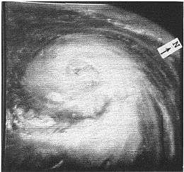
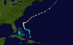
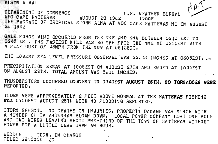
A tropical wave developed into a tropical depression along the southeast Florida coast on August 26. It moved northward along the coast, located beneath an anticyclone that aided in its intensification. The depression began a motion to the northeast on August 27, and that day it strengthened into Tropical Storm Alma about 150 mi (240 km) east of the Florida/Georgia border. This marked the latest development of the first storm since 1941. Alma steadily intensified as it paralleled the coastline of the Carolinas, becoming a hurricane on August 28 a few miles off the coast of Cape Hatteras. Despite its proximity, the storm produced peak wind gusts of only 53 mph (85 km/h) in Nags Head.[3] Wind gusts downed a power pole in Hatteras, which caused an hour long power outage for one-third of the town.[7] There, the storm tide was 3 ft (0.91 m) above normal, which resulted in some erosion.[3] The highest rainfall total from Alma in the United States was a report of 10.38 inches (264 mm) in Cape Hatteras.[8] Damage in the state amounted to $35,000.[3]
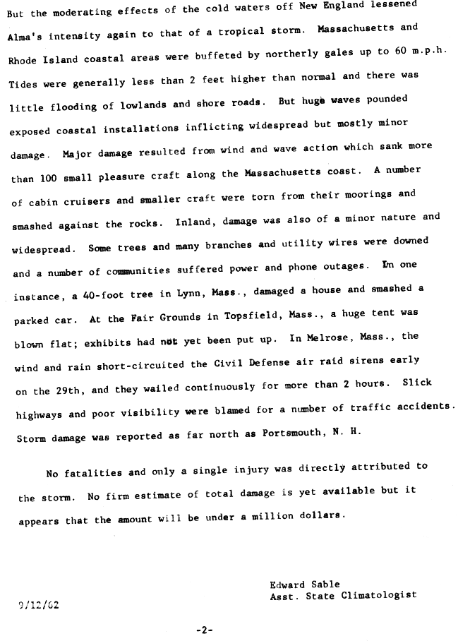
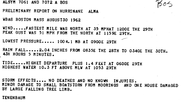
After passing the Outer Banks, Alma continued to intensify further, reaching peak winds of 100 mph (160 km/h) about 85 mi (135 km) south of Nantucket.[9] Despite its intensity, the hurricane never developed a well-defined eye. Alma quickly weakened to a tropical storm as it made its closest approach to New England,[3] due to cooler water temperatures.[10] In Rhode Island and Massachusetts along the coast, the storm produced northerly winds of 60 mph (97 km/h),[3] and one house was damaged by a fallen tree.[11] Tides reached 2 ft (0.61 m) above normal, which resulted in minor coastal flooding. However, Alma produced strong waves that destroyed over 100 boats. Damage from the storm was estimated at less than $1 million, though its rains were beneficial to drought-stricken areas of New England.[3] Precipitation extended northward through Maine, and storm damage was reported as far north as Portsmouth, New Hampshire. Slick roads resulted in several traffic accidents,[10] although there were no deaths. After moving by the region, Alma turned to the southeast due to a high pressure system to its north. It became extratropical on August 30.[3]
August tropical depression
| Tropical depression (SSHWS) | |||
|---|---|---|---|
| |||
| Duration | August 26 – August 30 | ||
| Peak intensity | 30 mph (45 km/h) (1-min) 1005 mbar (hPa) | ||

On August 26, a tropical depression formed in the western Gulf of Mexico about 280 mi (450 km) northeast of Tampico, Tamaulipas. It moved slowly to the north-northwest around a ridge without intensifying beyond winds of 30 mph (45 km/h). The system encountered wind shear throughout its duration, which displaced the convection from the center to its northeast. The depression struck just west of the Texas/Louisiana border on August 29 before dissipating on August 30. Rainfall in Texas was minimal, estimated around 1 in (25 mm). However, heavy amounts of precipitation fell across Louisiana, peaking at 23.13 in (588 mm) near Hackberry. Rainfall extended northeastward through Arkansas and Missouri.[12][13] On August 29 as the depression moved ashore, heavy rainfall caused street flooding in Cameron, Louisiana. Two tornadoes were reported in the town, one of which produced winds of 80 mph (130 km/h).[14] The storms damaged 115 houses or trailers, of which one was destroyed. There were 30 people injured, of whom 18 required hospital attention,[15] and there were three deaths.[14]
Tropical Storm Becky
| Tropical storm (SSHWS) | |||
|---|---|---|---|
| |||
| Duration | August 27 – August 31 | ||
| Peak intensity | 40 mph (65 km/h) (1-min) 1008 mbar (hPa) | ||


A tropical disturbance emerged from Africa in late August and developed into a weak tropical depression on August 27. For about 30 hours, the system affected the Cape Verde islands with rainfall, during which it moved slowly to the west and west-northwest. Late on August 28, it was estimated that the depression intensified into a tropical storm. The next day, satellite imagery observed a well-developed tropical cyclone in the far eastern Atlantic Ocean. In addition, a ship reported winds of force 9 on the Beaufort scale, suggesting winds of 50 mph (85 km/h). On that basis, the Weather Bureau initiated advisories on Tropical Storm Becky, despite the agency only issuing advisories for storms west of 35° W. Around that time, the storm moved over an area of anomalously warm water temperatures, which allowed for its intensification. On August 30, Becky turned to the north and northeast due to an approaching trough, becoming the easternmost cyclone since 1886 that a storm began a motion to the north. A Hurricane Hunters flight on August 31 indicated that Becky became extratropical about 70 mi (110 km) south of Santa Maria Island in the Azores. The storm's remnants continued to the northeast, dissipating on September 1 about 320 mi (520 km) west of Spain.[3][9]
Tropical Storm Celia
| Tropical storm (SSHWS) | |||
|---|---|---|---|
| |||
| Duration | September 12 – September 21 | ||
| Peak intensity | 70 mph (110 km/h) (1-min) 995 mbar (hPa) | ||


A tropical wave developed into a tropical depression on September 12, about 1000 mi (1600 km) east of the Lesser Antilles. However, satellite imagery indicated that it could have become a tropical cyclone a day earlier. Late on September 12, a ship reported winds of 40 mph (64 km/h), which provided the basis for the San Juan Weather Bureau to initiate advisories on Tropical Storm Celia. The storm quickly attained peak winds of 70 mph (110 km/h), and on September 13 a hurricane watch was issued for the northern Leeward Islands. However, Celia passed beneath a mid- to upper-level trough and quickly weakened. By late on September 14, a hurricane hunters flight indicated that the storm's structure no longer resembled that of a tropical cyclone. The next day, Celia weakened to a tropical depression, and the Weather Bureau discontinued tropical cyclone advisories. It turned to the north and later to the east, passing well southeast of Bermuda. On September 18, Celia began executing a loop to the north, during which it re-intensified into a tropical storm, as reported by ships. It attained winds of 45 mph (75 km/h) on September 19, but again weakened to a tropical depression the next day. Celia became extratropical on September 21, without having affected land.[3][9]
September Gulf of Mexico tropical depression
| Tropical depression (SSHWS) | |||
|---|---|---|---|
| |||
| Duration | September 20 – September 23 | ||
| Peak intensity | 30 mph (45 km/h) (1-min) 1010 mbar (hPa) | ||


An upper-level low spawned a tropical depression off the west coast of Florida on September 20. The depression moved very slowly to the north-northwest, which produced heavy rainfall from Naples to Tampa, Florida. The highest total was 16.60 in (422 mm) in Sarasota, although precipitation of over 1 in (25 mm) extended into Georgia and extreme southern South Carolina. A developing cyclone off the Carolinas caused the dissipation of the depression on September 23.[12][16]
The rains in Sarasota were the highest since 1945,[17] and some locations experienced 1 in 100 year rainfall totals.[18] The rains resulted in 3 ft (0.91 m) of floodwaters across western Florida,[19] and both the Manatee River and the Phillippi Creek experienced record crests. The flooding entered over 5,000 houses,[18] which forced the evacuation of more than 100 families. The floods also caused schools to close in three counties.[17] In addition, floodwaters affected thousands of acres of farmlands in six counties, and some did not dry out for several weeks.[18] Wind gusts reached 58 mph (93 km/h) in eastern Florida, and more than 20,000 people were left without power.[17] There was one death in the state related to the storm, and damage was estimated at $2.78 million.[18]
September Caribbean tropical depression

On September 27, a tropical depression developed east of the Lesser Antilles. It moved through the islands without intensifying beyond winds of 30 mph (40 km/h). The depression later crossed the entirety of the Caribbean Sea. On October 3, it struck northeastern Nicaragua, before becoming a remnant low pressure area the following day over Guatemala.[12]
Hurricane Daisy
| Category 2 hurricane (SSHWS) | |||
|---|---|---|---|
| |||
| Duration | September 29 – October 8 | ||
| Peak intensity | 110 mph (175 km/h) (1-min) ≤ 965 mbar (hPa) | ||

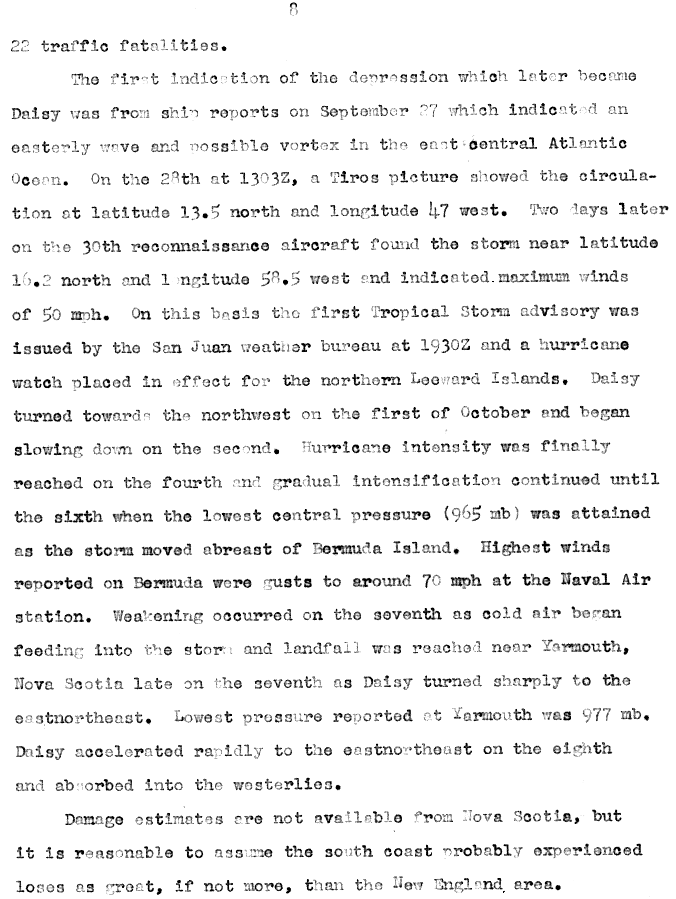
On September 29, reconnaissance aircraft indicated the formation of a tropical depression to the east of the Lesser Antilles. For several days it moved to the west-northwest, passing just north of the islands without intensifying further. This was due to its presence beneath an upper-level trough, although the system began intensifying as the trough dissipated. On October 2, after turning to the northwest between two high pressure areas, the depression strengthened into Tropical Storm Daisy. Developing an anticyclone aloft, the storm continued to gradually intensify, reaching hurricane strength on October 3. Two days later, Daisy turned to the north-northeast and attained peak winds of 110 mph (175 km/h). While passing west of Bermuda, the hurricane weakened slightly, although it re-intensified to its peak strength late on October 6. Cool air imparted weakening as Daisy turned northwestward, and on October 8, the hurricane slowed as it turned eastward, striking Yarmouth, Nova Scotia, with winds of 75 mph (120 km/h). It became extratropical later that day, and Daisy dissipated on October 9 south of Newfoundland.[3][9]
In New England, Hurricane Daisy's outer rainbands combined with an approaching nor'easter to drop torrential rainfall over the region for 65 hours, producing upwards of 12 in (300 mm) in portions of Massachusetts.[3] The highest total from Daisy alone was 9.47 in (241 mm) at Portland International Jetport in Maine;[20] this was the state's highest tropical cyclone rainfall total between 1950 and 2011.[21] Across the region, the rains caused widespread flood damage. In Maine, wind gusts reaching 70 mph (110 km/h) destroyed hundreds of small boats, along with high waves from the storm. In New England, Daisy left five injuries, one direct death, and about $1.1 million in damage.[3] Slick roads, however, resulted in 22 traffic fatalities.[22] In Nova Scotia, winds gusted to 85 mph (137 km/h), which destroyed three boats and left two towns without power service. Rough seas killed six people in the province.[23]
Hurricane Ella
| Category 3 hurricane (SSHWS) | |||
|---|---|---|---|
| |||
| Duration | October 14 – October 22 | ||
| Peak intensity | 115 mph (185 km/h) (1-min) ≤ 950 mbar (hPa) | ||
In the middle of October, an area of disturbed weather persisted across the Turks and Caicos Islands, associated with an upper-level low. On October 14, a tropical depression developed and moved northward. A day after forming, it intensified into Tropical Storm Ella as it began a track to the northwest, located east of a weakening upper-level trough. On October 17, Ella strengthened further into a hurricane as an anticyclone was gradually developing. An approaching trough turned the hurricane to the east-northeast on October 19, and later that day Ella attained its peak intensity of 115 mph (185 km/h); that made it the strongest hurricane of the season. It gradually weakened over cooler waters while accelerating to the northeast, and its eye grew to an unusually large diameter of 100 mi (160 km/h). Ella became extratropical on October 22 over the northern Atlantic as it interacted with an approaching cold front. Shortly thereafter its remnants moved over Newfoundland before dissipating on October 23.[3][9]
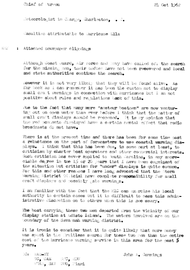
Ella is historically notable for its role in the Cuban Missile Crisis. The storm greatly complicated naval operations relating to the 'quarantine' blockade of Cuba and badly damaged several Soviet nuclear-armed submarines en route to the island, contributing to the escalation of the B-59 Incident.[24] Early in its duration, Hurricane Ella briefly threatened to strike the North Carolina coastline. Although it remained offshore, the hurricane produced significant beach erosion along the coast. There were two associated deaths from a missing motor boat that left Charleston, South Carolina.[3] The crew of two was declared deceased after a Coast Guard, Navy, and Air Force search failed to locate their bodies.[25] There was no damage in Canada from its remnants.[26]
See also
Storm names
The following names were used for named storms (tropical storms and hurricanes) that formed in the North Atlantic in 1962.[4] Names that were not assigned are marked in gray. Because of the season's relatively low impact, no storms were retired during the 1962 season, and none of the storms below were used for the first time.
|
|
References
- ↑ Staff writer (1962-06-13). "Hurricane Season Upon Us". The Windsor Star. United Press International. Retrieved 2011-10-07.
- ↑ Staff writer (1962-11-13). "Nature's Fury". The Evening Independent. Retrieved 2011-10-10.
- 1 2 3 4 5 6 7 8 9 10 11 12 13 14 15 16 17 18 Gordon E. Dunn (April 1963). "The Hurricane Season of 1962" (PDF). Monthly Weather Review: 199–207. Archived from the original (PDF) on 2011-12-10. Retrieved 2011-10-07.
- 1 2 Staff Writer (1962-06-01). "Watchers Await First Hurricane". The Tuscaloosa News. Associated Press. Retrieved 2011-10-07.
- ↑ Staff writer (1962-09-10). "Hurricane Season is Slowest in 30 Years". The Dispatch. United Press International. Retrieved 2011-10-07.
- ↑ Staff writer (1962-12-31). "Not One Hurricane Hit U.S. in 1962 - A 20th Century Record". Meriden Record. Associated Press. Retrieved 2011-10-09.
- ↑ WBO Cape Hatteras (1962-08-28). "The Passage of Tropical Storm Alma at WBO Cape Hatteras NC on August 28, 1962" (GIF). National Hurricane Center. Retrieved 2011-10-06.
- ↑ David M. Roth (2009-09-28). "Hurricane Alma - August 25-31, 1962". Hydrometeorological Prediction Center. Retrieved 2011-10-08.
- 1 2 3 4 5 National Hurricane Center; Hurricane Research Division (July 6, 2016). "Atlantic hurricane best track (HURDAT version 2)". United States National Oceanic and Atmospheric Administration. Retrieved December 5, 2016.
- 1 2 Edward Sable, Boston Weather Bureau Airway Station (1962-09-12). "Summary of Tropical Storm Alma". National Hurricane Center. Retrieved 2011-10-07.
- ↑ Tenenbaum, Boston Weather Bureau Airway Station (1962-08-30). "Preliminary Report on Hurricane Alma". National Hurricane Center. Retrieved 2011-10-07.
- 1 2 3 Davd M. Roth (2011). "CLIQR Database". National Oceanic and Atmospheric Administration. Retrieved 2011-01-06.
- ↑ David M. Roth (2009-09-22). "Tropical Depression - August 28-31, 1962". Hydrometeorological Prediction Center. Retrieved 2011-10-08.
- 1 2 Staff writer (1962-08-29). "Storm Kills 3 in Louisiana". Toledo Blade. Associated Press. Retrieved 2011-10-08.
- ↑ Staff Writer (1962-08-30). "Louisiana Town Begins Cleanup Job". The Evening Independent. Associated Press. Retrieved 2011-10-09.
- ↑ David M. Roth (2012-04-08). "Tropical Depression - September 20-23, 1962". Hydrometeorological Prediction Center. Retrieved 2011-10-09.
- 1 2 3 Staff Writer (1962-09-22). "Florida Makes Survey of Damage from Rainstorm". The Reading Eagle. Associated Press. Retrieved 2011-10-09.
- 1 2 3 4 "Report on Flood of 20-21 September 1962 Southwest Florida" (PDF). United States Army Corps of Engineers. November 1962. Retrieved 2011-10-09.
- ↑ Staff Writer (1962-09-21). "Storm Swamps Florida as Frost Nips New England". The Modesto Bee. Associated Press. Retrieved 2011-10-09.
- ↑ David M. Roth (2008-01-20). "Hurricane Daisy - October 6-8, 1962". Hydrometeorological Prediction Center. Retrieved 2011-10-08.
- ↑ Roth, David M; Weather Prediction Center (January 7, 2013). "Maximum Rainfall caused by Tropical Cyclones and their Remnants Per State (1950–2012)". Tropical Cyclone Point Maxima. United States National Oceanic and Atmospheric Administration's National Weather Service. Retrieved March 15, 2013.
- ↑ Neil L. Frank. "The 1962 Hurricane Season" (GIF). National Hurricane Center. Retrieved 2011-10-09.
- ↑ "1962-Daisy". Environment Canada. 2010-09-14. Retrieved 2011-10-08.
- ↑ Gary E. Weir; Walter J. Boyne (2003). Rising Tide: The Untold Story of the Russian Submarines that Fought the Cold War. New York: Basic Books. p. 75.
- ↑ John A. Cummings (1962-10-24). "Casualties Attributable to Hurricane Ella" (GIF). National Hurricane Center. Retrieved 2011-10-09.
- ↑ "1962-Ella". Environment Canada. 2009-11-05. Retrieved 2011-10-09.
External links
Tropical cyclones of the 1962 Atlantic hurricane season | ||
|---|---|---|
| ||
| ||