Ōmiya-ku, Saitama
| Ōmiya-ku, Saitama 大宮区 | |
|---|---|
| Ward | |
| Ōmiya Ward | |
|
Ōmiya Ward Office | |
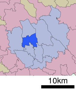 Location of Ōmiya-ku in Saitama | |
 Ōmiya-ku, Saitama
| |
| Coordinates: 35°54′23.2″N 139°37′43.1″E / 35.906444°N 139.628639°ECoordinates: 35°54′23.2″N 139°37′43.1″E / 35.906444°N 139.628639°E | |
| Country | Japan |
| Region | Kanto |
| Prefecture | Saitama |
| City | Saitama |
| Area | |
| • Total | 12.80 km2 (4.94 sq mi) |
| Population (February 2016) | |
| • Total | 113,742 |
| • Density | 8,890/km2 (23,000/sq mi) |
| Time zone | Japan Standard Time (UTC+9) |
| -Flower | Sakura |
| Phone number | 048-835-3156 |
| Address |
3-1 Daimon, Ōmiya-ku, Saitama-shi, Saitama-ken 330-8501 |
| Website |
www |

Ōmiya (大宮区 Ōmiya-ku) is one of ten wards of the city of Saitama, in Saitama Prefecture, Japan, and is located in the northeastern part of the city. As of 1 February 2016, the ward had an estimated population of 113,742 and a population density of 8,890 persons per km². Its total area was 12.80 square kilometres (4.94 sq mi). Although Urawa-ku is the governmental center of Saitama City, Ōmiya-ku is the most active commercial and business centre in both Saitama City and Saitama Prefecture thanks to its transport infrastructure, especially railways connected at Ōmiya Station.
Geography
Ōmiya Ward is within the Ōmiya Terrace of the Kantō plain, in the center of Saitama City. It is in the Greater Tokyo Area and about 25 km north of central Tokyo.
Neighboring Municipalities
Ōmiya-ku is surrounded by Nishi-ku (to the west), Kita-ku (north), Minuma-ku (east), Urawa-ku (southeast), Chūō-ku (south), and Sakura-ku (southwest).
History
Ōmiya derives its name from a famous Shinto shrine, the Hikawa Shrine, which has been a place of pilgrimage since at least the Heian period. During the Edo period, the area flourished as Ōmiya-shuku, a post station on the Nakasendō highway, which connected Edo with Kyoto. Following the Meiji restoration, it became part of Urawa Prefecture which merged with Iwatsuki, Urawa, and Oshi Prefectures n 1871 to form Saitama Prefecture. The modern town of Ōmiya was officially created within Kitaadachi District, Saitama with the establishment of the municipalities system on April 1, 1889.
On November 3, 1940 Ōmiya merged with the neighboring villages of Mihashi, Osato, Miyahara and Nisshin and was elevated to city status. Ōmiya continued to expand after the end of the war, absorbing the villages of Sashiougi, Mamiya, Uemizu, Katayanagi, Haruoka, and Nanasato on January 1, 1955.
On May 1, 2001 Ōmiya merged with Urawa and Yono to form Saitama City. In April 2003 Saitama became a city designated by government ordinance, and now the area of former Ōmiya City was divided between Kita-ku (north), Minuma-ku (east), Nishi-ku (west), and Ōmiya-ku (south).
Education
- Kokusai Gakuin Saitama Junior College
- University of Human Arts and Sciences
- Urawa-ku has nine elementary schools, eight middle schools, and eight high schools.
- The ward also has a North Korean school, Saitama Korean Elementary and Middle School (埼玉朝鮮初中級学校). This school was previously in the City of Ōmiya.[1]
Transportation
Railway
- JR East – Tohoku Shinkansen / Joetsu Shinkansen / Akita Shinkansen / Yamagata Shinkansen / Hokuriku Shinkansen / Kawagoe Line
- JR East – Tohoku Main Line / Takasaki Line / Keihin Tohoku Line
- Tobu Railway – Noda Line
- Saitama New Urban Transit New Shuttle - Ina Line
Highway
Local attractions
- Ōmiya Park
- Hikawa Shrine
- Railway Museum
- Saitama Red Cross Hospital in Omiya
- The bonsai nurseries in the neighbouring Kita-ku is usually referred to as the "Ōmiya Bonsai Village" because it was in the area of former Ōmiya city.
References
- ↑ "埼玉朝鮮初中級学校とは?." Saitama Korean Elementary and Middle School. Retrieved on October 14, 2015. "〒330-0804 埼玉県大宮市堀之内町1の501の1"
External links
![]() Media related to Ōmiya-ku, Saitama at Wikimedia Commons
Media related to Ōmiya-ku, Saitama at Wikimedia Commons
- Official website (Japanese)
| Wards of Saitama | ||
|---|---|---|
| Core cities | ||
| Special cities | ||
| Cities | ||
| Chichibu District | ||
| Hiki District | ||
| Iruma District | ||
| Kitaadachi District | ||
| Kitakatsushika District | ||
| Kodama District | ||
| Minamisaitama District | ||
| Ōsato District | ||
