Đurđevac
| Đurđevac | |
|---|---|
| Town | |
|
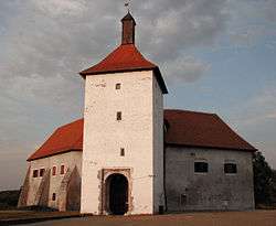
Đurđevac Castle | |
 Đurđevac Location Đurđevac in Croatia | |
| Coordinates: 46°02′N 17°04′E / 46.04°N 17.07°E | |
| Country |
|
| County |
|
| Government | |
| • Mayor | Željko Lacković |
| Area | |
| • Total | 157.19 km2 (60.69 sq mi) |
| Population (2011) | |
| • Total | 8,264 |
| • Density | 53/km2 (140/sq mi) |
| (municipality total) | |
| Time zone | CET (UTC+1) |
| • Summer (DST) | CEST (UTC+2) |
| Postal code | 48350 |
| Area code(s) | 048 |
| Website | Grad Đurđevac |
Đurđevac is a town and municipality in the Koprivnica-Križevci County in Croatia. According to the 2011 census, there are a total of 8,264 inhabitants in the municipality, in the following settlements:[1]
- Budrovac, population 373
- Čepelovac, population 345
- Đurđevac, population 6,349
- Grkine, population 131
- Mičetinac, population 207
- Severovci, population 142
- Sirova Katalena, population 281
- Suha Katalena, population 337
- Sveta Ana, population 99
In the census of 2011, Croats formed an absolute majority at 94.92%.[2]
The citizens of the town colloquially call themselves "Picoki".
History
Until 1918, Đurđevac (named MILITÄR SANCT GEORGEN before 1850[3]) was part of the Austrian monarchy (Kingdom of Croatia-Slavonia after the compromise of 1867), in the Croatian Military Frontier, under the WARASDIN-ST. GEORGENER Regiment N°VI.[4] In the late 19th century and early 20th century, Đurđevac was a district capital in the Bjelovar-Križevci County of the Kingdom.
Sights and events
- Old town Đurđevac
- Picokijada - Legenda o picokima
- Church of st. George in Đurđevac
- Đurđevečki peski
- Park-Forest Đurđevac
Notable people
- Boris Braun - member of the notable Braun family, University professor and honorary Citizen of Đurđevac
- Mladen Markač - Commander of Croatian Special Police during Operation Storm during the Croatian War of Independence (1991–1995), and afterwards held the rank of Colonel General
References
- ↑ "Population by Age and Sex, by Settlements, 2011 Census: Đurđevac". Census of Population, Households and Dwellings 2011. Zagreb: Croatian Bureau of Statistics. December 2012.
- ↑ "Population by Ethnicity, by Towns/Municipalities, 2011 Census: County of Koprivnica-Križevci". Census of Population, Households and Dwellings 2011. Zagreb: Croatian Bureau of Statistics. December 2012.
- ↑ Handbook of Austria and Lombardy-Venetia Cancellations on the Postage Stamp Issues 1850-1864, by Edwin MUELLER, 1961.
- ↑ Probably until 1881.
External links
- Đurđevac official site
- Awarded "EDEN - European Destinations of Excellence" non traditional tourist destination 2008
Subdivisions of Koprivnica-Križevci County | ||
|---|---|---|
| Towns |
|  |
| Municipalities | ||
Coordinates: 46°01′38″N 17°04′02″E / 46.02722°N 17.06722°E
