Towner, Colorado
| Towner, Colorado | |
|---|---|
| Census-designated place (CDP) | |
 Location in Kiowa County and the state of Colorado | |
| Coordinates: 38°28′14″N 102°04′44″W / 38.47056°N 102.07889°WCoordinates: 38°28′14″N 102°04′44″W / 38.47056°N 102.07889°W | |
| Country |
|
| State |
|
| County | Kiowa County[1] |
| Elevation[1] | 3,927 ft (1,197 m) |
| Time zone | MST (UTC-7) |
| • Summer (DST) | MDT (UTC-6) |
| ZIP code[2] | 81071 (Sheridan Lake) |
| Area code(s) | 719 |
| GNIS feature ID | 0204824 |
Towner is a census-designated place in Kiowa County, Colorado, United States. The population as of the 2010 Census was 22.[3] The U.S. Post Office at Sheridan Lake (ZIP Code 81071) now serves Towner postal addresses. The town was originally known as Memphis. It was a frequent attraction for Kansans when their state was "dry." This was due to the close proximity of Towner to the Kansas border.[2] Towner is the easternmost town in Colorado, located less than 2 miles from the Kansas border.
The town currently supports two grain elevators and boasts a population of around 50 permanent residents. Its population swells during harvest due to the influx of harvesting crews who often camp in the town. The closest gas station is approximately 11 miles away in Sheridan Lake, Colorado. Towner also shares a school with Sheridan Lake named Plainview School. It is responsible for the education of students in grades Pre-K thru 12. Hunting opportunities are also abundant in the area with deer, antelope, and pheasant commonplace, as well as an occasional elk sighting.[4]
Geography
Towner is located at 38°28′14″N 102°04′44″W / 38.47056°N 102.07889°W (38.470659,-102.078953).
See also
References
- 1 2 "US Board on Geographic Names". United States Geological Survey. 2007-10-25. Retrieved 2008-01-31.
- 1 2 "ZIP Code Lookup" (JavaScript/HTML). United States Postal Service. January 3, 2007. Retrieved January 3, 2007.
- ↑ Colorado Trend Report 2: State and Complete Places (Sub-state 2010 Census Data). Missouri Census Data Center. Accessed 2011-02-25.
- ↑ http://webarchive.org/web/20061023130311/http://www.kcedf.org/Kiowa+Cnty+Fact+Book.doc
Municipalities and communities of Kiowa County, Colorado, United States | ||
|---|---|---|
| Towns | 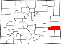 | |
| CDPs | ||
| Unincorporated communities | ||