Stuttgart, Kansas
| Stuttgart, Kansas | |
|---|---|
| Unincorporated community | |
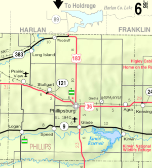 KDOT map of Phillips County (legend) | |
 Stuttgart  Stuttgart | |
| Coordinates: 39°47′58″N 99°27′19″W / 39.79944°N 99.45528°WCoordinates: 39°47′58″N 99°27′19″W / 39.79944°N 99.45528°W | |
| Country | United States |
| State | Kansas |
| County | Phillips |
| Elevation | 1,988 ft (606 m) |
| Time zone | CST (UTC-6) |
| • Summer (DST) | CDT (UTC-5) |
| Area code | 785 |
| GNIS feature ID | 471923 [1] |
Stuttgart is an unincorporated community in Phillips County, Kansas, United States, founded on February 6, 1888. It lies in the north of Kansas at U.S. Route 36 between Prairie View and Phillipsburg, not far from the border with Nebraska. Its beginning can be traced back to the early 1870s, when the first settlers arrived in the area. From its beginnings as shelters and small block houses, Stuttgart grew to have two Lutheran churches, a public school, hotel, cafe, bank, cinema, hairdresser, wood yard, grocer's shop, railway depot, grain silo, repairshop, blacksmith, dairy, and more.
A post office was opened in Stuttgart in 1888, and remained in operation until it was discontinued in 1986.[2]
Today there is yet another Lutheran church, a grain silo, a garage and a gas station with service, as well as a photo studio.
References
- ↑ U.S. Geological Survey Geographic Names Information System: Stuttgart, Kansas
- ↑ "Kansas Post Offices, 1828-1961, page 2". Kansas Historical Society. Retrieved 22 June 2014.
External links
Municipalities and communities of Phillips County, Kansas, United States | ||
|---|---|---|
| Cities |  | |
| Unincorporated communities | ||