Shirley, Arkansas
| Shirley, Arkansas | |
|---|---|
| Town | |
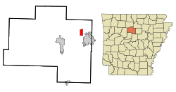 Location in Van Buren County and the state of Arkansas | |
| Coordinates: 35°39′21″N 92°19′0″W / 35.65583°N 92.31667°WCoordinates: 35°39′21″N 92°19′0″W / 35.65583°N 92.31667°W | |
| Country | United States |
| State | Arkansas |
| County | Van Buren |
| Area | |
| • Total | 2.5 sq mi (6.4 km2) |
| • Land | 2.4 sq mi (6.2 km2) |
| • Water | 0.1 sq mi (0.2 km2) |
| Elevation | 551 ft (168 m) |
| Population (2000) | |
| • Total | 337 |
| • Density | 134.8/sq mi (52.7/km2) |
| Time zone | Central (CST) (UTC-6) |
| • Summer (DST) | CDT (UTC-5) |
| ZIP codes | 72088, 72153 |
| Area code(s) | 501 |
| FIPS code | 05-63980 |
| GNIS feature ID | 0054811 |
Shirley is a town in northeast Van Buren County, Arkansas, United States, along the Middle Fork of the Little Red River. A one-time railroad outpost, the community today is oriented toward agriculture and recreational activities due to the river and Greers Ferry Lake. The population was 223 at the 2010 census.
Geography
Shirley is located at 35°39′21″N 92°19′0″W / 35.65583°N 92.31667°W (35.655936, -92.316554).[1]
According to the United States Census Bureau, the town has a total area of 2.5 square miles (6.5 km2), of which 2.4 square miles (6.2 km2) is land and 0.1 square miles (0.26 km2) (2.85%) is water.
Demographics
| Historical population | |||
|---|---|---|---|
| Census | Pop. | %± | |
| 1920 | 349 | — | |
| 1930 | 292 | −16.3% | |
| 1940 | 365 | 25.0% | |
| 1950 | 259 | −29.0% | |
| 1960 | 197 | −23.9% | |
| 1970 | 269 | 36.5% | |
| 1980 | 354 | 31.6% | |
| 1990 | 363 | 2.5% | |
| 2000 | 337 | −7.2% | |
| 2010 | 291 | −13.6% | |
| Est. 2015 | 282 | [2] | −3.1% |
As of the census[4] of 2010, there were 223 people, 136 households, and 91 families residing in the town. The population density was 140.9 inhabitants per square mile (54.4/km²). There were 132 housing units at an average density of 71.9 per square mile (27.8/km²). The racial makeup of the town was 96.14% White, 0.89% Black or African American, 1.89% Native American, and 2.08% from two or more races. 1.19% of the population were Hispanic or Latino of any race.
There were 132 households out of which 33.1% had children under the age of 18 living with them, 58.8% were married couples living together, 6.6% had a female householder with no husband present, and 32.4% were non-families. 29.4% of all households were made up of individuals and 14.7% had someone living alone who was 65 years of age or older. The average household size was 2.48 and the average family size was 3.08.
In the town the population was spread out with 27.0% under the age of 18, 7.7% from 18 to 24, 27.6% from 25 to 44, 19.0% from 45 to 64, and 18.7% who were 65 years of age or older. The median age was 35 years. For every 100 females there were 89.3 males. For every 100 females age 18 and over, there were 92.2 males.
The median income for a household in the town was $23,958, and the median income for a family was $30,938. Males had a median income of $21,875 versus $14,545 for females. The per capita income for the town was $10,096. About 14.1% of families and 23.2% of the population were below the poverty line, including 34.2% of those under age 18 and 11.1% of those age 65 or over.
Education
Public education for elementary and secondary students is provided by Shirley School District, which includes Shirley Elementary School and Shirley High School.[5]
References
- ↑ "US Gazetteer files: 2010, 2000, and 1990". United States Census Bureau. 2011-02-12. Retrieved 2011-04-23.
- ↑ "Annual Estimates of the Resident Population for Incorporated Places: April 1, 2010 to July 1, 2015". Retrieved July 2, 2016.
- ↑ "Census of Population and Housing". Census.gov. Retrieved June 4, 2015.
- ↑ "American FactFinder". United States Census Bureau. Retrieved 2008-01-31.
- ↑ "District Reference Map, Van Buren County" (PDF). U.S. Census Bureau. Retrieved 5 April 2013.
External links
Municipalities and communities of Van Buren County, Arkansas, United States | ||
|---|---|---|
| Cities | 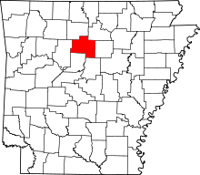 | |
| Towns | ||
| CDP | ||
| Townships |
| |
| Unincorporated communities | ||
| Ghost town | ||
| Footnotes | ‡This populated place also has portions in an adjacent county or counties | |