Rosebud, North Carolina
| Rosebud | |
|---|---|
| Unincorporated community | |
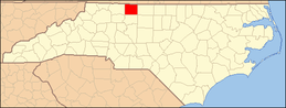
 Rosebud Location within the state of North Carolina | |
| Coordinates: 36°18′25″N 80°10′51″W / 36.30694°N 80.18083°WCoordinates: 36°18′25″N 80°10′51″W / 36.30694°N 80.18083°W | |
| Country | United States |
| State | North Carolina |
| County | Stokes |
| Time zone | Eastern (EST) (UTC-5) |
| • Summer (DST) | EDT (UTC-4) |
| ZIP code | 27052 |
Rosebud is an unincorporated community in Stokes County, North Carolina, United States, approximately two miles west-northwest of Walnut Cove.
Municipalities and communities of Stokes County, North Carolina, United States | ||
|---|---|---|
| City |
|  |
| Towns | ||
| Village | ||
| CDPs | ||
| Other unincorporated communities |
| |
| Footnotes | ‡This populated place also has portions in an adjacent county or counties. | |
This article is issued from Wikipedia - version of the 11/24/2014. The text is available under the Creative Commons Attribution/Share Alike but additional terms may apply for the media files.