Plymouth Township, Russell County, Kansas
| Plymouth Township | |
|---|---|
| Township | |
 Location of Plymouth Township in Russell County | |
| Coordinates: 38°49′38″N 98°32′22″W / 38.82722°N 98.53944°WCoordinates: 38°49′38″N 98°32′22″W / 38.82722°N 98.53944°W | |
| Country | United States |
| State | Kansas |
| County | Russell |
| Area | |
| • Total | 107.44 sq mi (278.3 km2) |
| • Land | 98.30 sq mi (254.6 km2) |
| • Water | 9.14 sq mi (23.7 km2) 8.5% |
| Elevation | 1,683 ft (513 m) |
| Population (2010)[1] | |
| • Total | 280 |
| • Density | 2.6/sq mi (1.0/km2) |
| Time zone | Central (CST) (UTC-6) |
| • Summer (DST) | CDT (UTC-5) |
| ZIP code | 67490, 67525, 67634, 67648 |
| Area code(s) | 785 |
| GNIS feature ID | 475235[2] |
Plymouth Township is a township in Russell County, Kansas, United States. As of the 2010 United States Census, it had a population of 280.[1]
Geography
The center of Plymouth Township is located at 38°49′38″N 98°32′22″W / 38.82722°N 98.53944°W (39.8272331, -98.5395133) at an elevation of 1,683 feet (513 m).[2] The township lies in the Smoky Hills region of the Great Plains.[3] The eastern two-thirds of Wilson Lake lies in the northern part of the township. The Smoky Hill River flows windingly east through the township's center, fed by Coal Creek, one of its tributaries, which runs north-northeast through the southern half of the township. Another of the river's tributaries, Blood Creek, flows northeast through the extreme southeastern corner of the township.[4][5]
According to the United States Census Bureau, Plymouth Township occupies an area of 107.44 square miles (278.3 km²) of which 98.30 square miles (254.6 km²) is land and 9.14 square miles (23.7 km²) is water. Comprising east-central and southeastern Russell County, it includes the city of Dorrance, which is located in the west-central part of the township, and it borders Fairview Township to the north, Lincoln County's Pleasant Township to the northeast, Lincoln County's Highland Township and Ellsworth County's Wilson and Noble Townships to the east, Barton County's Cleveland and Beaver Townships to the south, Center Township to the west, and Luray Township to the northwest.[6]
Demographics
| Historical population | |||
|---|---|---|---|
| Census | Pop. | %± | |
| 1880 | 1,073 | — | |
| 1890 | 1,096 | 2.1% | |
| 1900 | 1,134 | 3.5% | |
| 1910 | 1,116 | −1.6% | |
| 1920 | 1,131 | 1.3% | |
| 1930 | 1,016 | −10.2% | |
| 1940 | 1,000 | −1.6% | |
| 1950 | 795 | −20.5% | |
| 1960 | 604 | −24.0% | |
| 1970 | 430 | −28.8% | |
| 1980 | 373 | −13.3% | |
| 1990 | 316 | −15.3% | |
| 2000 | 319 | 0.9% | |
| 2010 | 280 | −12.2% | |
| U.S. Decennial Census | |||
As of the 2010 census, there were 280 people, 132 households, and 80 families residing in the township. The population density was 2.6 people per square mile (1/km²). There were 219 housing units at an average density of 2.2 per square mile (0.9/km²). The racial makeup of the township was 96.8% White, 2.9% American Indian, and 0.4% Asian. Hispanics or Latinos of any race were 0.4% of the population.[1]
There were 132 households out of which 20.5% had children under the age of 18 living with them, 52.3% were married couples living together, 4.5% had a male householder with no wife present, 3.8% had a female householder with no husband present, and 39.4% were non-families. 36.4% of all households were made up of individuals, and 15.1% had someone living alone who was 65 years of age or older. The average household size was 2.12, and the average family size was 2.70.[1]
In the township, the population was spread out with 16.8% under the age of 18, 5.4% from 18 to 24, 21.8% from 25 to 44, 32.4% from 45 to 64, and 23.6% who were 65 years of age or older. The median age was 49.5 years. For every 100 females, there were 112.1 males. For every 100 females age 18 and over, there were 109.9 males age 18 and over.[1]
Education
Plymouth Township lies within Unified School District (USD) 112, based in Lorraine, Kansas.[7] Local public school students attend school in nearby Wilson.[8]
Transportation
Interstate 70 and U.S. Route 40 run concurrently east-west through the central part of the township. The former alignment of U.S. 40, now a paved county road, runs southeast-northwest through the township south of I-70/U.S. 40. K-232, a north-south route, enters the northeastern part of the township from the north and runs south along the eastern shore of Wilson Lake before turning slightly southeast and exiting the county. A network of mostly unpaved county roads is laid out in a rough grid pattern across the township. Shoreline Road, a paved county road, runs roughly parallel to the southern shoreline of Wilson Lake, terminating at its junction with K-232. Another paved road, 200th Boulevard, enters the township from the west 3.5 miles south of Dorrance, turns north, and runs north through Dorrance before finally terminating at the southern shore of Wilson Lake.[4][5]
The Kansas Pacific (KP) line of the Union Pacific Railroad runs southeast-northwest through the township, parallel to the old alignment of U.S. 40.[4][9]
References
- 1 2 3 4 5 "American FactFinder". United States Census Bureau. Retrieved 2011-08-28.
- 1 2 "US Board on Geographic Names". United States Geological Survey. 2007-10-25. Retrieved 2008-01-31.
- ↑ "2003-2004 Official Transportation Map" (PDF). Kansas Department of Transportation. 2003. Retrieved 2011-08-28.
- 1 2 3 "General Highway Map - Russell County, Kansas (township map)" (PDF). Kansas Department of Transportation. 1975. Retrieved 2011-08-28.
- 1 2 "General Highway Map - Russell County, Kansas" (PDF). Kansas Department of Transportation. 2010-10-01. Retrieved 2011-08-28.
- ↑ "Kansas: 2000 - Population and Housing Counts" (PDF). United States Census Bureau. July 2003. Retrieved 2011-08-28.
- ↑ "Kansas Unified School Districts (map)" (PDF). Kansas State Department of Education. Retrieved 2011-08-28.
- ↑ "New District Map". USD 328. Retrieved 2011-08-28.
- ↑ "UPRR Common Line Names" (PDF). Union Pacific Railroad. Retrieved 2010-10-23.
Municipalities and communities of Russell County, Kansas, United States | ||
|---|---|---|
| Cities | 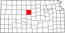 | |
| Townships | ||
| Unincorporated communities | ||
| Footnotes | ‡This populated place also has portions in an adjacent county or counties | |