Lafayette Township, Chautauqua County, Kansas
| Lafayette Township | |
|---|---|
| Township | |
 Location in Chautauqua County | |
| Coordinates: 37°14′30″N 096°09′51″W / 37.24167°N 96.16417°WCoordinates: 37°14′30″N 096°09′51″W / 37.24167°N 96.16417°W | |
| Country | United States |
| State | Kansas |
| County | Chautauqua |
| Area | |
| • Total | 60.19 sq mi (155.9 km2) |
| • Land | 59.35 sq mi (153.71 km2) |
| • Water | 0.84 sq mi (2.19 km2) 1.4% |
| Elevation | 978 ft (298 m) |
| Population (2000) | |
| • Total | 65 |
| • Density | 1.1/sq mi (0.4/km2) |
| GNIS feature ID | 0469523 |
Lafayette Township is a township in Chautauqua County, Kansas, USA. As of the 2000 census, its population was 65.
Geography
Lafayette Township covers an area of 60.19 square miles (155.9 km2) and contains no incorporated settlements. According to the USGS, it contains three cemeteries: Crum, Saint Charles and Union Chapel.
The streams of Bachelor Creek, Broker Creek, Coon Creek, Coon Creek, North Salt Creek and Turkey Creek run through this township.
References
External links
Municipalities and communities of Chautauqua County, Kansas, United States | ||
|---|---|---|
| Cities | 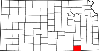 | |
| Unincorporated communities | ||
| Townships | ||
This article is issued from Wikipedia - version of the 11/11/2013. The text is available under the Creative Commons Attribution/Share Alike but additional terms may apply for the media files.