Denison, Kansas
| Denison, Kansas | |
|---|---|
| City | |
 Location within Jackson County and Kansas | |
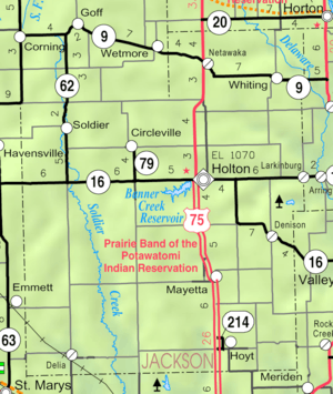 KDOT map of Jackson County (legend) | |
| Coordinates: 39°23′36″N 95°37′42″W / 39.39333°N 95.62833°WCoordinates: 39°23′36″N 95°37′42″W / 39.39333°N 95.62833°W | |
| Country | United States |
| State | Kansas |
| County | Jackson |
| Area[1] | |
| • Total | 0.11 sq mi (0.28 km2) |
| • Land | 0.11 sq mi (0.28 km2) |
| • Water | 0 sq mi (0 km2) |
| Elevation | 1,043 ft (318 m) |
| Population (2010)[2] | |
| • Total | 187 |
| • Estimate (2012[3]) | 187 |
| • Density | 1,700/sq mi (670/km2) |
| Time zone | Central (CST) (UTC-6) |
| • Summer (DST) | CDT (UTC-5) |
| ZIP code | 66419 |
| Area code | 785 |
| FIPS code | 20-17625 [4] |
| GNIS feature ID | 0478205 [5] |
Denison is a city in Jackson County, Kansas, United States. As of the 2010 census, the city population was 187.[6]
History
19th century
Denison was founded as a result of the Kansas City, Wyandotte and Northwestern Railway laying tracks that would connect Valley Falls in Jefferson Co. and Holton, in Jackson Co. The railroad was slated to come through one mile south of an existing village, Tippinville, and in September 1887, A.D. Walker and Hollis Tucker, land speculators, laid out lots for a new town, which was named after Tucker's hometown, Denison, Ohio. Most of the houses and two churches in Tippinville were bodily moved to the new townsite, which is primarily in Garfield Township, with a small portion in Cedar Township (it was all Cedar Township at first). By August 1890, Tippinvile had been officially vacated and by 1894 Denison had a population of 150.
A number of Civil War veterans are buried in the Denison Cemetery (and nearby cemeteries, North and South Cedar Cemeteries), and there is one veteran of the Mexican–American War, G. W. White, buried at Denison. Eliza Cody Myers (Mrs. George Myers), sister of William F. "Buffalo Bill" Cody is also buried there. It was a truly exciting event for school children when Buffalo Bill came to Denison to visit his niece, Nellie Myers Copas, and her family.
A post office, named North Cedar, was established in 1867. The first school, built of logs, was established in 1858 south of present-day Denison, on the site of the North Cedar Cemetery. The first church in the area, of the Christian denomination was founded in 1856 by the Rev. J.T. Gardiner. The Reformed Presbyterian Church was established in 1871, with the Rev. J.S.T. Milligan the founding pastor; the United Presbyterian Church, in 1880; and the Denison Methodist Episcopal Church, in 1889. The Christian, United Presbyterian and Methodist churches united to become the Denison Union Church in 1958, and later became the Denison Bible Church. The Denison Christian Church building, erected in 1878, now houses the Denison Historical Museum, and is one of three Jackson Co. buildings included in the State Register of Historic Places.
20th century
The Denison State Bank was founded in 1901, and after its second robbery, in 1938, was moved to Holton, the county seat, where it thrives today under the same name. The Denison Rural High School was established in 1916, and a brick building was erected. It burned in 1938 and a new school building was completed in 1941. Due to school district unification, the last class to graduate from Denison High School was in 1969. However the school continued to serve lower grades until it closed its doors in 1990. Area students now attend schools in Holton.
In 1991, Allen Gardiner, a fifth-generation descendant of Denison area pioneers, published a 357-page definitive history of the area, titled "Denison, Kansas: A Record of a Town and Its People (With Observations on the Human Condition)". The book contains census records, burials in four area cemeteries, high school alumni from 1916 to 1969, and 100 family genealogies.
Geography
Denison is located at 39°23′36″N 95°37′42″W / 39.39333°N 95.62833°W (39.393206, -95.628409).[7] According to the United States Census Bureau, the city has a total area of 0.11 square miles (0.28 km2), all of it land.[1]
Demographics
| Historical population | |||
|---|---|---|---|
| Census | Pop. | %± | |
| 1910 | 295 | — | |
| 1920 | 240 | −18.6% | |
| 1930 | 202 | −15.8% | |
| 1940 | 176 | −12.9% | |
| 1950 | 166 | −5.7% | |
| 1960 | 184 | 10.8% | |
| 1970 | 248 | 34.8% | |
| 1980 | 231 | −6.9% | |
| 1990 | 225 | −2.6% | |
| 2000 | 231 | 2.7% | |
| 2010 | 187 | −19.0% | |
| Est. 2015 | 185 | [8] | −1.1% |
| U.S. Decennial Census | |||
Denison is part of the Topeka, Kansas Metropolitan Statistical Area.
2010 census
As of the census[2] of 2010, there were 187 people, 76 households, and 50 families residing in the city. The population density was 1,700.0 inhabitants per square mile (656.4/km2). There were 87 housing units at an average density of 790.9 per square mile (305.4/km2). The racial makeup of the city was 96.3% White, 0.5% Native American, and 3.2% from two or more races. Hispanic or Latino of any race were 1.1% of the population.
There were 76 households of which 31.6% had children under the age of 18 living with them, 46.1% were married couples living together, 11.8% had a female householder with no husband present, 7.9% had a male householder with no wife present, and 34.2% were non-families. 30.3% of all households were made up of individuals and 11.8% had someone living alone who was 65 years of age or older. The average household size was 2.46 and the average family size was 2.94.
The median age in the city was 31.8 years. 27.8% of residents were under the age of 18; 8.6% were between the ages of 18 and 24; 24.6% were from 25 to 44; 26.8% were from 45 to 64; and 12.3% were 65 years of age or older. The gender makeup of the city was 46.5% male and 53.5% female.
2000 census
As of the census[4] of 2000, there were 231 people, 82 households, and 62 families residing in the city. The population density was 1,973.8 people per square mile (743.2/km²). There were 88 housing units at an average density of 751.9 per square mile (283.1/km²). The racial makeup of the city was 93.94% White, 1.30% African American, 2.60% Native American, 1.73% from other races, and 0.43% from two or more races. Hispanic or Latino of any race were 1.73% of the population.
There were 82 households out of which 34.1% had children under the age of 18 living with them, 59.8% were married couples living together, 12.2% had a female householder with no husband present, and 23.2% were non-families. 19.5% of all households were made up of individuals and 11.0% had someone living alone who was 65 years of age or older. The average household size was 2.77 and the average family size was 3.19.
In the city the population was spread out with 28.1% under the age of 18, 12.1% from 18 to 24, 24.7% from 25 to 44, 23.8% from 45 to 64, and 11.3% who were 65 years of age or older. The median age was 33 years. For every 100 females there were 100.9 males. For every 100 females age 18 and over, there were 102.4 males.
The median income for a household in the city was $27,500, and the median income for a family was $33,250. Males had a median income of $24,375 versus $17,778 for females. The per capita income for the city was $13,378. About 9.3% of families and 15.0% of the population were below the poverty line, including 36.6% of those under the age of eighteen and 5.6% of those sixty five or over.
References
- 1 2 "US Gazetteer files 2010". United States Census Bureau. Retrieved 2012-07-06.
- 1 2 "American FactFinder". United States Census Bureau. Retrieved 2012-07-06.
- ↑ "Population Estimates". United States Census Bureau. Retrieved 2013-05-29.
- 1 2 "American FactFinder". United States Census Bureau. Retrieved 2008-01-31.
- ↑ "US Board on Geographic Names". United States Geological Survey. 2007-10-25. Retrieved 2008-01-31.
- ↑ "2010 City Population and Housing Occupancy Status". U.S. Census Bureau. Retrieved March 17, 2012.
- ↑ "US Gazetteer files: 2010, 2000, and 1990". United States Census Bureau. 2011-02-12. Retrieved 2011-04-23.
- ↑ "Annual Estimates of the Resident Population for Incorporated Places: April 1, 2010 to July 1, 2015". Retrieved July 2, 2016.
External links
| Wikimedia Commons has media related to Denison, Kansas. |
- City
- Schools
- USD 336, local school district
- Bed & Breakfast
- Maps
- Denison City Map, KDOT
Municipalities and communities of Jackson County, Kansas, United States | ||
|---|---|---|
| Cities |  | |
| Unincorporated communities | ||
| Indian reservations | ||
| Townships | ||
| Footnotes | ‡This populated place also has portions in an adjacent county or counties | |