Dale, Oklahoma
| Dale | |
|---|---|
| Unincorporated community | |
 Dale  Dale Location within the state of Oklahoma | |
| Coordinates: 35°23′24″N 97°2′42″W / 35.39000°N 97.04500°WCoordinates: 35°23′24″N 97°2′42″W / 35.39000°N 97.04500°W | |
| Country | United States |
| State | Oklahoma |
| County | Pottawatomie |
| Population (2010) | |
| • Total | 181 |
| Time zone | Central (CST) (UTC-6) |
| • Summer (DST) | CDT (UTC-5) |
Dale is a small unincorporated community located on State Highway 270 in Pottawatomie County, Oklahoma. It lies in the North Canadian River bottom, a few miles northwest of Shawnee. The 2010 census recorded a population of 186.[1]
Dale was platted along the Rock Island railroad line before statehood. The Dale Post Office opened October 26, 1893. The community was named for Frank Dale, a territorial judge. Dale also has a public school system.
References
- ↑ CensusViewer:Dale, Oklahoma Population. Retrieved August 7, 2013.
Sources
Shirk, George H. Oklahoma Place Names. Norman: University of Oklahoma Press, 1987. ISBN 0-8061-2028-2 .
Municipalities and communities of Pottawatomie County, Oklahoma, United States | ||
|---|---|---|
| Cities | 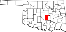 | |
| Towns | ||
| CDP | ||
| Other unincorporated communities |
| |
| Ghost towns | ||
| Footnotes | ‡This populated place also has portions in an adjacent county or counties | |
This article is issued from Wikipedia - version of the 7/31/2016. The text is available under the Creative Commons Attribution/Share Alike but additional terms may apply for the media files.