Arnold, Kansas
| Arnold, Kansas | |
|---|---|
| Unincorporated community | |
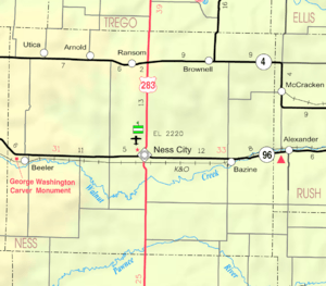 KDOT map of Ness County (legend) | |
 Arnold, Kansas  Arnold, Kansas Location within the state of Kansas | |
| Coordinates: 38°38′25″N 100°2′46″W / 38.64028°N 100.04611°WCoordinates: 38°38′25″N 100°2′46″W / 38.64028°N 100.04611°W | |
| Country | United States |
| State | Kansas |
| County | Ness |
| Time zone | Central (CST) (UTC-6) |
| • Summer (DST) | CDT (UTC-5) |
| ZIP codes | 67515 |
| Website | Website |
Arnold is an unincorporated community in northern Ness County, Kansas, United States. It lies along K-4, north-northwest of the city of Ness City, the county seat of Ness County.[1] Its elevation is 2,566 feet (782 m), and it is located at 38°38′25″N 100°2′46″W / 38.64028°N 100.04611°W (38.6402921, -100.0462373).[2] Although it is unincorporated, it has a post office, with the ZIP code of 67515.[3]
History
Arnold was a station and shipping point on the Missouri Pacific Railroad.[4]
The first post office in Arnold was established in about 1902.[5]
References
- ↑ Rand McNally. The Road Atlas '08. Chicago: Rand McNally, 2008, p. 40.
- ↑ Geographic Names Information System Feature Detail Report, Geographic Names Information System, 1978-10-13. Accessed 2008-04-12.
- ↑ Zip Code Lookup Archived May 17, 2011, at the Wayback Machine.
- ↑ Blackmar, Frank Wilson (1912). Kansas: A Cyclopedia of State History, Embracing Events, Institutions, Industries, Counties, Cities, Towns, Prominent Persons, Etc. Standard Publishing Company. p. 103.
- ↑ "Kansas Post Offices, 1828-1961, page 2". Kansas Historical Society. Retrieved 19 June 2014.
External links
Municipalities and communities of Ness County, Kansas, United States | ||
|---|---|---|
| Cities |  | |
| Unincorporated communities | ||
This article is issued from Wikipedia - version of the 11/18/2016. The text is available under the Creative Commons Attribution/Share Alike but additional terms may apply for the media files.