Wheatfields, Arizona
| Wheatfields, Arizona | |
|---|---|
| Census-designated place | |
 Wheatfields  Wheatfields | |
| Coordinates: 33°28′51″N 110°51′7″W / 33.48083°N 110.85194°WCoordinates: 33°28′51″N 110°51′7″W / 33.48083°N 110.85194°W | |
| Country | United States |
| State | Arizona |
| County | Gila |
| Area | |
| • Total | 8.1 sq mi (20.9 km2) |
| • Land | 8.1 sq mi (20.9 km2) |
| • Water | 0.0 sq mi (0.0 km2) |
| Elevation | 3,121 ft (951 m) |
| Population (2010) | |
| • Total | 785 |
| • Density | 97/sq mi (37.6/km2) |
| Time zone | MST (no DST) (UTC-7) |
| Area code(s) | 928 |
| FIPS code | 04-82120 |
| GNIS feature ID | 2582899 |
Wheatfields is a census-designated place (CDP) in Gila County, Arizona, United States. The population was 785 at the 2010 United States Census.[1]
Geography
Wheatfields is located in southern Gila County in the valley of Pinal Creek. Arizona State Route 188 forms the western edge of the CDP, leading northwest 22 miles (35 km) to Theodore Roosevelt Lake and south 10 miles (16 km) to Globe, the county seat.
According to the United States Census Bureau, the Wheatfields CDP has a total area of 8.1 square miles (20.9 km2), all of it land.[1]
References
- 1 2 "Geographic Identifiers: 2010 Demographic Profile Data (G001): Wheatfields CDP, Arizona". U.S. Census Bureau, American Factfinder. Retrieved November 8, 2016.
Municipalities and communities of Gila County, Arizona, United States | ||
|---|---|---|
| City | 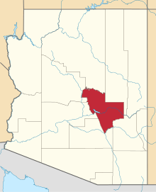 | |
| Towns | ||
| CDPs |
| |
| Unincorporated communities | ||
| Indian reservations | ||
| Ghost towns | ||
| Footnotes | ‡This populated place also has portions in an adjacent county or counties | |
This article is issued from Wikipedia - version of the 11/8/2016. The text is available under the Creative Commons Attribution/Share Alike but additional terms may apply for the media files.