Weber, Minnesota
| Weber, Minnesota | |
|---|---|
| Unincorporated community | |
 Weber, Minnesota  Weber, Minnesota Location of the community of Weber | |
| Coordinates: 45°28′30″N 93°07′27″W / 45.47500°N 93.12417°WCoordinates: 45°28′30″N 93°07′27″W / 45.47500°N 93.12417°W | |
| Country | United States |
| State | Minnesota |
| County | Isanti |
| Township | Oxford Township and North Branch Township |
| Elevation | 932 ft (284 m) |
| Time zone | Central (CST) (UTC-6) |
| • Summer (DST) | CDT (UTC-5) |
| ZIP code | 55056 |
| Area code(s) | 763 |
| GNIS feature ID | 655000[1] |
Weber is an unincorporated community in Isanti County, Minnesota, United States.
The community is located at the junction of Isanti County Road 12 (Jodrell Street NE) and Isanti County Road 47 (279th Avenue NE).
Weber is located within Oxford Township and North Branch Township. The North Branch of the Sunrise River flows from west to east, a quarter mile north of Weber. Nearby places include North Branch, Stacy, Isanti, and Cambridge.
Local business establishments include Tommy's Roadhouse Bar. Formerly it was the site of the Weber Store. St. John's Lutheran Church (LCMS) is located about 1500 feet north of the junction of 12 and 47.
References
- Official State of Minnesota Highway Map – 2013/2014 edition
Municipalities and communities of Isanti County, Minnesota, United States | ||
|---|---|---|
| Cities | 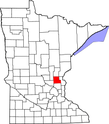 | |
| Townships | ||
| CDP | ||
| Unincorporated communities | ||
| Ghost town | ||
| Footnotes | ‡This populated place also has portions in an adjacent county or counties | |
This article is issued from Wikipedia - version of the 7/28/2016. The text is available under the Creative Commons Attribution/Share Alike but additional terms may apply for the media files.