Pentress, West Virginia
| Pentress | |
|---|---|
| Census-designated place (CDP) | |
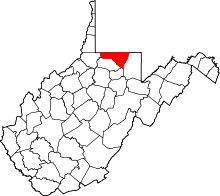
 Pentress Location within the state of West Virginia | |
| Coordinates: 39°42′37″N 80°9′37″W / 39.71028°N 80.16028°WCoordinates: 39°42′37″N 80°9′37″W / 39.71028°N 80.16028°W | |
| Country | United States |
| State | West Virginia |
| County | Monongalia |
| Area[1] | |
| • Total | 0.609 sq mi (1.58 km2) |
| • Land | 0.606 sq mi (1.57 km2) |
| • Water | 0.003 sq mi (0.008 km2) |
| Population (2010)[2] | |
| • Total | 175 |
| • Density | 290/sq mi (110/km2) |
| Time zone | Eastern (EST) (UTC-5) |
| • Summer (DST) | EDT (UTC-4) |
| ZIP codes | 26544 |
Pentress is a census-designated place (CDP) in northern Monongalia County, West Virginia, United States. It lies along West Virginia Route 7 northwest of the city of Morgantown, the county seat of Monongalia County.[3] Its elevation is 951 feet (290 m). "Pentress" is not the only name the community has had; at various times in its history, it has been known as Minors Mills, New Brownsville, Pentrees, Pentress Junction, Statler Town, Statlers Town, Statlersville, and Stradlerstown.[4] The present name of Pentress was selected by an early settler who reportedly wanted a Welsh name.[5] Although it is unincorporated, it has a post office, with the ZIP code of 26544.[6] As of the 2010 census, its population was 175.[2]
References
- ↑ "US Gazetteer files: 2010, 2000, and 1990". United States Census Bureau. 2011-02-12. Retrieved 2011-04-23.
- 1 2 "American FactFinder". United States Census Bureau. Retrieved 2011-05-14.
- ↑ Rand McNally. The Road Atlas '08. Chicago: Rand McNally, 2008, p. 112.
- ↑ Geographic Names Information System Feature Detail Report, Geographic Names Information System, 1980-06-27. Accessed 2008-03-29.
- ↑ Kenny, Hamill (1945). West Virginia Place Names: Their Origin and Meaning, Including the Nomenclature of the Streams and Mountains. Piedmont, WV: The Place Name Press. p. 480.
- ↑ Zip Code Lookup