Colony Township, Greeley County, Kansas
| Colony Township | |
|---|---|
| Township | |
 Location in Greeley County | |
| Coordinates: 38°31′25″N 101°56′17″W / 38.52361°N 101.93806°WCoordinates: 38°31′25″N 101°56′17″W / 38.52361°N 101.93806°W | |
| Country | United States |
| State | Kansas |
| County | Greeley |
| Area | |
| • Total | 354.77 sq mi (918.86 km2) |
| • Land | 354.77 sq mi (918.86 km2) |
| • Water | 0 sq mi (0 km2) 0% |
| Elevation | 3,812 ft (1,162 m) |
| Population (2000) | |
| • Total | 172 |
| • Density | 0.5/sq mi (0.2/km2) |
| GNIS feature ID | 0485231 |
Colony Township is a township in Greeley County, Kansas, USA. As of the 2000 census, its population was 172.
Geography
Colony Township covers an area of 354.77 square miles (918.9 km2) and contains no incorporated settlements. According to the USGS, it contains two cemeteries: Mathews and Rogers.
The stream of South Fork White Woman Creek runs through this township.
Transportation
Colony Township contains two airports or landing strips: Tuttle Landing Field and Walter Airport.
References
External links
Municipalities and communities of Greeley County, Kansas, United States | ||
|---|---|---|
| Cities | 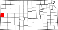 | |
| Unincorporated community | ||
| Townships | ||
This article is issued from Wikipedia - version of the 11/28/2016. The text is available under the Creative Commons Attribution/Share Alike but additional terms may apply for the media files.