Cecile, California
Coordinates: 36°42′03″N 119°43′04″W / 36.70083°N 119.71778°W
| Cecile | |
|---|---|
| Unincorporated community | |
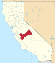
 Cecile  Cecile Location in California | |
| Coordinates: 36°42′03″N 119°43′04″W / 36.70083°N 119.71778°W | |
| Country | United States |
| State | California |
| County | Fresno County |
| Elevation[1] | 305 ft (93 m) |
Cecile is an unincorporated community in Fresno County, California.[1] It is located on the Atchison, Topeka and Santa Fe Railroad 1.5 miles (2.4 km) northeast of Malaga,[2] at an elevation of 305 feet (93 m).[1]
Climate
According to the Köppen Climate Classification system, Cecile has a semi-arid climate, abbreviated "BSk" on climate maps.[3]
References
- 1 2 3 U.S. Geological Survey Geographic Names Information System: Cecile, California
- ↑ Durham, David L. (1998). California's Geographic Names: A Gazetteer of Historic and Modern Names of the State. Clovis, Calif.: Word Dancer Press. p. 1014. ISBN 1-884995-14-4.
- ↑ Climate Summary for Cecile, California
This article is issued from Wikipedia - version of the 7/5/2016. The text is available under the Creative Commons Attribution/Share Alike but additional terms may apply for the media files.