Barnesville, Georgia
| Barnesville, Georgia | |
|---|---|
| City | |
|
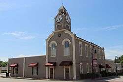
Barnesville City Hall in Barnesville, Georgia | |
| Nickname(s): Buggy Town | |
 Location in Lamar County and the state of Georgia | |
| Coordinates: 33°3′11″N 84°9′22″W / 33.05306°N 84.15611°WCoordinates: 33°3′11″N 84°9′22″W / 33.05306°N 84.15611°W | |
| Country | United States |
| State | Georgia |
| County | Lamar |
| Barnes' Store | 1826 |
| Barnesville | June 1831 |
| Incorporated City of Barnesville | February 20, 1854 |
| Government | |
| • Type | City Council |
| • City Manager | Kenneth D. Roberts, Sr. |
| Area | |
| • Total | 5.7 sq mi (14.6 km2) |
| • Land | 5.7 sq mi (14.6 km2) |
| • Water | 0 sq mi (0 km2) |
| Elevation | 850 ft (259 m) |
| Population (2010) | |
| • Total | 6,755 |
| • Density | 1,047.7/sq mi (409/km2) |
| Time zone | Eastern (EST) (UTC-5) |
| • Summer (DST) | EDT (UTC-4) |
| ZIP code | 30204 |
| Area code(s) | 770 |
| FIPS code | 13-05344[1] |
| GNIS feature ID | 0331094[2] |
| Website | Barnesville |
Barnesville is a city in Lamar County, Georgia, United States. The city is a part of the Atlanta Metropolitan Area. As of the 2010 census, the city had a population of 6,755.[3] The city is the county seat of Lamar County.[4]
Barnesville was once dubbed the "Buggy Capital of the South" as the town produced about 9,000 buggies a year around the turn of the 20th century.[5] Each year in the third week of September the town hosts an annual Buggy Days celebration.
History
Barnesville was founded in 1826 and named for local tavern owner Gideon Barnes. In 1920, Barnesville was designated seat of the newly formed Lamar County.[6]
Barnesville served as a major hospital site for wounded southern troops during the Civil War. Local families took wounded soldiers into their homes and treated them, with highly successful recovery rates. Major General William B. Bate, CSA of Hardees Corps., wounded in Atlanta at Utoy Creek on August 10, 1864, was treated here. After the war, General Bate was elected Governor of Tennessee and served in the United States Senate until his death in 1912. He commented on his successful recovery as a result of the kindness of the local populace in Barnesville.
Notable weather events
In the early morning hours of April 28, 2011, at 12:38 A.M., a tornado rated EF3 on the Enhanced Fujita Scale with 140 mph winds touched down in Pike County four miles south of Meansville. The tornado went on to destroy several homes in Barnesville. Two deaths occurred in Barnesville along Grove Street. The tornado also destroyed a Chevron gas station and a church in Barnesville. Three tractor trailers also blown off of Interstate 75 at approximately 1:02 A.M. This tornado was part of the April 25–28, 2011 tornado outbreak.
Geography
Barnesville is located at 33°3′11″N 84°9′22″W / 33.05306°N 84.15611°W (33.053090, -84.156217).[7]
According to the United States Census Bureau, the city has a total area of 5.7 square miles (15 km2), of which, 5.7 square miles (15 km2) of it is land and 0.18% is water.
Demographics
| Historical population | |||
|---|---|---|---|
| Census | Pop. | %± | |
| 1870 | 754 | — | |
| 1880 | 1,962 | 160.2% | |
| 1890 | 1,839 | −6.3% | |
| 1900 | 3,036 | 65.1% | |
| 1910 | 3,068 | 1.1% | |
| 1920 | 3,059 | −0.3% | |
| 1930 | 3,236 | 5.8% | |
| 1940 | 3,535 | 9.2% | |
| 1950 | 4,185 | 18.4% | |
| 1960 | 4,919 | 17.5% | |
| 1970 | 4,935 | 0.3% | |
| 1980 | 4,887 | −1.0% | |
| 1990 | 4,747 | −2.9% | |
| 2000 | 5,972 | 25.8% | |
| 2010 | 6,755 | 13.1% | |
| Est. 2015 | 6,625 | [8] | −1.9% |
As of the census[1] of 2011, there were 6,669 people, 2,079 households, and 1,382 families residing in the city. The population density was 1,055.9 people per square mile (407.4/km²). There were 2,257 housing units at an average density of 399.1 per square mile (154.0/km²). The racial makeup of the city was 48.11% White, 49.87% African American, 0.15% Native American, 0.33% Asian, 0.03% Pacific Islander, 0.57% from other races, and 0.94% from two or more races. Hispanic or Latino of any race were 1.69% of the population.
There were 2,079 households out of which 31.5% had children under the age of 18 living with them, 37.1% were married couples living together, 25.3% had a female householder with no husband present, and 33.5% were non-families. 29.0% of all households were made up of individuals and 12.0% had someone living alone who was 65 years of age or older. The average household size was 2.47 and the average family size was 3.04.
In the city the population was spread out with 23.6% under the age of 18, 17.7% from 18 to 24, 26.4% from 25 to 44, 18.5% from 45 to 64, and 13.8% who were 65 years of age or older. The median age was 32 years. For every 100 females there were 83.8 males. For every 100 females age 18 and over, there were 78.6 males.
The median income for a household in the city was $30,375, and the median income for a family was $36,492. Males had a median income of $26,740 versus $20,160 for females. The per capita income for the city was $15,423. About 16.1% of families and 20.3% of the population were below the poverty line, including 31.5% of those under age 18 and 15.6% of those age 65 or over.
Education
Lamar County School District
The Lamar County School District holds pre-school to grade twelve, and consists of two elementary schools, a middle school, and a high school.[10] The district has 143 full-time teachers and over 2,600 students.[11]
- Lamar County Elementary School
- Lamar County Primary School
- Lamar County Middle School
- Lamar County Comprehensive High School
Private education
- St. George's Episcopal School (K-8)
- Rock Springs Christian Academy
Higher education
Music
Barnesville was the location of an auto accident that killed 16-year-old Jeanette Clark, who was on a date with J.L. Hancock, also 16, on December 22, 1962. This accident was (falsely) rumored to be the inspiration of the hit song "Last Kiss" written by Wayne Cochran, Joe Carpenter, Randall Hoyal & Bobby McGlon (1961). Hancock was driving a 1954 Chevrolet on the Saturday before Christmas with some friends. In heavy traffic on U.S. Highway 341 their car hit a tractor-trailer carrying a load of logs. Clark, Hancock and Wayne Cooper were killed. Cochran lived on Georgia's Route 19/41 when he wrote "Last Kiss", only 15 miles away from the crash site. He rerecorded "Last Kiss" for release on King Records in 1963 and dedicated it to Clark, a fact which probably explains the association of the song with the tragic crash.[13]
Annual Events & Festivals
The Barnesville-Lamar County Chamber of Commerce hosts three annual festivals each year.
- The BBQ & Blues Festival is held the last weekend in April and features an FBA(Florida Barbeque Association) certified cooking competition, food vendors, arts and crafts vendors, and live entertainment throughout the weekend.
- The Summer in the Sticks Country Music Concert is held the 3rd Saturday in July and features live bands, food vendors, and arts and crafts vendors. In 2014 it featured a guitar auction and cornhole tournament.
- The Buggy Days Festival celebrates Barnesville’s heritage as the Buggy Capital of the South during the late 1800s. The event has been named a Top 20 Event in the Southeast for five out of eight years, often featured in major publications such as Southern Living magazine. Buggy Days is held on the third full weekend in September. More than 150 artists and craftspersons sell their handmade items on Main Street. Activities include a beauty pageant, concert, and vendors from throughout the region.
Nearby events include the following,
- The Vintage Karting Association with GSKA holds an annual 3-day kart race event in late March at Lamar County Speedway on Highway 36, just west of Barnesville's downtown. This well attended and noted weekend event attracts competitors from all over the United States and Canada who celebrate the glory days of kart racing competition in the 1960s, 70s and 80s. Then, karters numbering in the hundreds invaded Barnesville, Forsyth, Griffin, and Thomaston for the Winter Olympics under International Kart Federation & World Karting Association sanction. GSKA currently leases the track and regularly holds races there.
Notable people
- Wayne Cochran - musician
- Louise Smith - NASCAR driver
- John T. Walker - Archbishop of Washington, born in Barnesville
References
- 1 2 "American FactFinder". United States Census Bureau. Archived from the original on September 11, 2013. Retrieved 2008-01-31.
- ↑ "US Board on Geographic Names". United States Geological Survey. 2007-10-25. Retrieved 2008-01-31.
- ↑ American FactFinder - Results
- ↑ "Find a County". National Association of Counties. Archived from the original on 2012-07-12. Retrieved 2011-06-07.
- ↑ "Buggy Capital of the South".
- ↑ Hellmann, Paul T. (May 13, 2013). Historical Gazetteer of the United States. Routledge. p. 220. Retrieved 30 November 2013.
- ↑ "US Gazetteer files: 2010, 2000, and 1990". United States Census Bureau. 2011-02-12. Retrieved 2011-04-23.
- ↑ "Annual Estimates of the Resident Population for Incorporated Places: April 1, 2010 to July 1, 2015". Retrieved July 2, 2016.
- ↑ "Census of Population and Housing". Census.gov. Archived from the original on May 11, 2015. Retrieved June 4, 2015.
- ↑ Georgia Board of Education, Retrieved June 22, 2010.
- ↑ School Stats, Retrieved June 22, 2010.
- ↑ Gordon College, Retrieved June 22, 2010.
- ↑ "LAST KISS by J. FRANK WILSON & THE CAVALIERS". www.songfacts.com. Retrieved 18 July 2015.
External links
- The Herald Gazette - Local Print Newspaper, Internet News source, and blog
- Gordon College - a state college of the University System of Georgia
- Lamar County School System Webpage
- The Barnesville Dispatch-Local Internet News source
- Lamar County Chamber of Commerce
- Barnesville Buggy Days
Municipalities and communities of Lamar County, Georgia, United States | ||
|---|---|---|
| Cities |  | |
| Town | ||