Zeithain
| Zeithain | ||
|---|---|---|
| ||
 Zeithain | ||
Location of Zeithain within Meißen district 
 | ||
| Coordinates: 51°20′N 13°21′E / 51.333°N 13.350°ECoordinates: 51°20′N 13°21′E / 51.333°N 13.350°E | ||
| Country | Germany | |
| State | Saxony | |
| District | Meißen | |
| Government | ||
| • Mayor | Hannes Berger | |
| Area | ||
| • Total | 81.49 km2 (31.46 sq mi) | |
| Population (2015-12-31)[1] | ||
| • Total | 5,839 | |
| • Density | 72/km2 (190/sq mi) | |
| Time zone | CET/CEST (UTC+1/+2) | |
| Postal codes | 01619 | |
| Dialling codes | 03525 | |
| Vehicle registration | MEI | |
| Website | www.zeithain.de | |

Zeithain (Upper Sorbian: Cytań) is a municipality in the district of Meißen, in Saxony, Germany.
Historically, it is known for the Zeithain Encampment (Zeithainer Zeltlager or Zeithainer Lustlager), which was a huge agglomeration of tents and troops, involving the whole 27,000-men-strong army of August the Strong. This event took place from 1 to 26 June 1730.[2]
During World War II a large prisoner-of-war camp, Stalag IV-B/H, was located in Zeithain. A memorial and museum commemorate it.[3]
Municipality subdivisions
Zeithain includes the following subdivisions:
- Cottewitz
- Gohlis
- Jacobsthal
- Kreinitz
- Lorenzkirch
- Moritz
- Neudorf
- Promnitz
- Röderau-Bobersen
- Zschepa
Gallery
-

Zeithain Encampment in 1730
-

Memorial Ehrenhain, Zeithain
-

Memorial stone April 1945 in Lorenzkirch
-
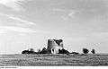
Ruin of the Holländermmühle in Lorenzkirch, Zeithain
Twin towns
 Teningen, Germany
References
- ↑ "Aktuelle Einwohnerzahlen nach Gemeinden 2015] (Einwohnerzahlen auf Grundlage des Zensus 2011)" (PDF). Statistisches Landesamt des Freistaates Sachsen (in German). July 2016.
- ↑ Holger Schuckelt: The Turkish Chamber: Oriental Splendour in the Dresden Armoury, Munich: Deutscher Kunstverlag, 2010, ISBN 978-3-422-06914-5, p. 112
- ↑ Memorial and History of Zeithain camp
Towns and municipalities in Meissen (district) | ||
|---|---|---|
This article is issued from Wikipedia - version of the 10/31/2016. The text is available under the Creative Commons Attribution/Share Alike but additional terms may apply for the media files.