Zanesville, Ohio
| Zanesville, Ohio | |
|---|---|
| City | |
|
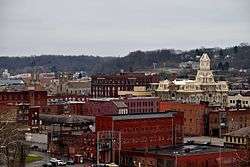
The view of downtown Zanesville from Putnam Hill Park | |
| Nickname(s): "City of Natural Advantages", "Y City", "Clay City", "Pottery Capital of The World", "The Y Bridge City" | |
 Location of Zanesville in Muskingum County and the state of Ohio | |
| Coordinates: 39°56′46″N 82°0′44″W / 39.94611°N 82.01222°WCoordinates: 39°56′46″N 82°0′44″W / 39.94611°N 82.01222°W | |
| Country | United States |
| State | Ohio |
| County | Muskingum |
| Government | |
| • Mayor | Jeff Tilton |
| Area[1] | |
| • Total | 12.14 sq mi (31.44 km2) |
| • Land | 11.77 sq mi (30.48 km2) |
| • Water | 0.37 sq mi (0.96 km2) |
| Elevation[2] | 676 ft (206 m) |
| Population (2010)[3] | |
| • Total | 25,487 |
| • Estimate (2012[4]) | 25,411 |
| • Density | 2,165.4/sq mi (836.1/km2) |
| Time zone | Eastern (EST) (UTC-5) |
| • Summer (DST) | EDT (UTC-4) |
| ZIP codes | 43701-43702 |
| Area code(s) | 740 |
| FIPS code | 39-88084[5] |
| GNIS feature ID | 1071002[2] |
| Website | http://www.coz.org/ |
Zanesville is a city in and the county seat of Muskingum County, Ohio, United States.[6] The population was 25,487 at the 2010 census.
History
Zanesville was named after Ebenezer Zane (1747–1811), who had constructed Zane's Trace, a pioneer road from Wheeling, Virginia (now in West Virginia) to Maysville, Kentucky through present-day Ohio. In 1797, he gave land as payment to his son-in-law, John McIntire (1759–1815), at the point where Zane's Trace met the Muskingum River. With Zane's help, McIntire platted the town and opened an inn and ferry by 1799. In 1801, Zanesville was officially renamed from Westbourne (Zane's chosen town name).
From 1810–1812, the city was the second state capital of Ohio.[7] The National Road runs through Zanesville as U.S. Route 40. The city grew quickly in the 1820s–1850s. Over 5,000 Union soldiers, along with hundreds of townsfolk, were stationed in the Zanesville area to protect the city in 1863 during Morgan's Raid. Novelist Zane Grey, a descendant of the Zane family, was born in the city.
The city has two engineering landmarks: the Muskingum River Canal, designated a National Historic Civil Engineering Landmark; and the Zanesville Y-Bridge, the only such structure in the United States still in use. It is listed on the National Register of Historic Places.
Colony Square Mall opened in 1981.
Geography
Zanesville is located at 39°56′46″N 82°0′44″W / 39.94611°N 82.01222°W (39.946049, −82.012150),[8] along the Muskingum River at its confluence with the Licking River. It lies within the ecoregion of the Western Allegheny Plateau.[9]
According to the United States Census Bureau, the city has a total area of 12.14 square miles (31.44 km2), of which 11.77 square miles (30.48 km2) is land and 0.37 square miles (0.96 km2) is water.[1]
The area has important deposits of clay which were exploited by a number of pottery companies in the first half of the twentieth century. Famous companies included Roseville pottery, Weller pottery, the J.B. Owens Pottery Company, the Zanesville Stoneware Company, the Mosaic Tile Company, the American Encaustic Tiling Company, and the T.B. Townsend Brick Yard under the ownership of T.B. Townsend.
Climate
| Climate data for Zanesville, Ohio (1981–2010 normals) | |||||||||||||
|---|---|---|---|---|---|---|---|---|---|---|---|---|---|
| Month | Jan | Feb | Mar | Apr | May | Jun | Jul | Aug | Sep | Oct | Nov | Dec | Year |
| Average high °F (°C) | 37.1 (2.8) |
41.1 (5.1) |
51.4 (10.8) |
63.3 (17.4) |
72.2 (22.3) |
80.4 (26.9) |
83.7 (28.7) |
82.8 (28.2) |
76.0 (24.4) |
64.5 (18.1) |
52.9 (11.6) |
40.6 (4.8) |
62.2 (16.8) |
| Average low °F (°C) | 20.5 (−6.4) |
22.9 (−5.1) |
30.1 (−1.1) |
39.7 (4.3) |
49.0 (9.4) |
58.0 (14.4) |
62.2 (16.8) |
60.6 (15.9) |
52.9 (11.6) |
41.7 (5.4) |
33.5 (0.8) |
24.6 (−4.1) |
41.3 (5.2) |
| Average precipitation inches (mm) | 2.66 (67.6) |
2.17 (55.1) |
3.00 (76.2) |
3.44 (87.4) |
4.19 (106.4) |
4.04 (102.6) |
3.79 (96.3) |
3.23 (82) |
3.01 (76.5) |
2.61 (66.3) |
3.14 (79.8) |
2.58 (65.5) |
37.86 (961.7) |
| Average snowfall inches (cm) | 7.2 (18.3) |
4.2 (10.7) |
3.8 (9.7) |
1.6 (4.1) |
0 (0) |
0 (0) |
0 (0) |
0 (0) |
0 (0) |
.1 (0.3) |
.9 (2.3) |
3.4 (8.6) |
21.2 (54) |
| Average precipitation days (≥ 0.01 in) | 13.4 | 10.9 | 12.2 | 13.0 | 13.2 | 11.3 | 10.6 | 9.5 | 8.9 | 9.6 | 11.2 | 12.7 | 136.5 |
| Average snowy days (≥ 0.1 in) | 7.7 | 4.5 | 3.7 | .8 | 0 | 0 | 0 | 0 | 0 | .1 | 1.5 | 4.2 | 22.5 |
| Source: NOAA[10] | |||||||||||||
Demographics
| Historical population | |||
|---|---|---|---|
| Census | Pop. | %± | |
| 1800 | 474 | — | |
| 1810 | 1,154 | 143.5% | |
| 1820 | 2,052 | 77.8% | |
| 1830 | 3,094 | 50.8% | |
| 1840 | 4,766 | 54.0% | |
| 1850 | 7,929 | 66.4% | |
| 1860 | 9,229 | 16.4% | |
| 1870 | 10,011 | 8.5% | |
| 1880 | 18,113 | 80.9% | |
| 1890 | 21,009 | 16.0% | |
| 1900 | 23,538 | 12.0% | |
| 1910 | 28,026 | 19.1% | |
| 1920 | 29,569 | 5.5% | |
| 1930 | 36,440 | 23.2% | |
| 1940 | 37,500 | 2.9% | |
| 1950 | 40,517 | 8.0% | |
| 1960 | 39,077 | −3.6% | |
| 1970 | 33,045 | −15.4% | |
| 1980 | 28,600 | −13.5% | |
| 1990 | 26,778 | −6.4% | |
| 2000 | 25,586 | −4.5% | |
| 2010 | 25,487 | −0.4% | |
| Est. 2015 | 25,498 | [11] | 0.0% |
| Sources:[12][13][14][15] | |||
In the 1950s, Zanesville was known for its population of light-skinned blacks who could "pass" (be admitted to whites-only places). This characteristic was due to a history of racial intermixing dating back to Zanesville's role as a stop on the Underground Railroad.[16]
2010 census
As of the census[3] of 2010, there were 25,487 people, 10,864 households, and 6,176 families residing in the city. The population density was 2,165.4 inhabitants per square mile (836.1/km2). There were 12,385 housing units at an average density of 1,052.3 per square mile (406.3/km2). The racial makeup of the city was 84.4% White, 9.7% African American, 0.4% Native American, 0.4% Asian, 0.4% from other races, and 4.7% from two or more races. Hispanic or Latino of any race were 1.2% of the population.
There were 10,864 households of which 31.3% had children under the age of 18 living with them, 32.1% were married couples living together, 19.1% had a female householder with no husband present, 5.7% had a male householder with no wife present, and 43.2% were non-families. 36.2% of all households were made up of individuals and 14.9% had someone living alone who was 65 years of age or older. The average household size was 2.29 and the average family size was 2.97.
The median age in the city was 36.3 years. 25.1% of residents were under the age of 18; 9.8% were between the ages of 18 and 24; 25.6% were from 25 to 44; 24.5% were from 45 to 64; and 15.2% were 65 years of age or older. The gender makeup of the city was 46.6% male and 53.4% female.
2000 census
As of the census[14] of 2000, there were 25,586 people, 10,572 households, and 6,438 families residing in the city. The population density was 2,276.8 people per square mile (878.9/km²). There were 11,662 housing units at an average density of 1,037.8 per square mile (400.6/km²). The racial makeup of the city was 85.48% White, 10.76% African American, 0.40% Native American, 0.23% Asian, 0.02% Pacific Islander, 0.42% from other races, and 2.70% from two or more races. Hispanic or Latino of any race were 0.79% of the population.
There were 10,572 households out of which 30.7% had children under the age of 18 living with them, 38.5% were married couples living together, 18.0% had a female householder with no husband present, and 39.1% were non-families. 33.4% of all households were made up of individuals and 14.5% had someone living alone who was 65 years of age or older. The average household size was 2.36 and the average family size was 2.99.
In the city the population was spread out with 26.8% under the age of 18, 9.5% from 18 to 24, 27.8% from 25 to 44, 20.5% from 45 to 64, and 15.5% who were 65 years of age or older. The median age was 35 years. For every 100 females there were 85.3 males. For every 100 females age 18 and over, there were 79.3 males.
The median income for a household in the city was $26,642, and the median income for a family was $31,932. Males had a median income of $27,902 versus $20,142 for females. The per capita income for the city was $15,192. About 19.3% of families and 22.4% of the population were below the poverty line, including 32.3% of those under age 18 and 14.8% of those age 65 or over.
Transportation
The city is served by Zanesville Municipal Airport, built during WW-2 and opened near the end of the War. It has two 5000+ runways. The airport had commercial flights from the late 1940s until the early 1970s.
The city is also served by several railroad lines.
Interstate 70 (I-70), a major east-west interstate highway, passes through the city. Closely paralleling I-70 is US 40, which roughly follows the route of the original National Road. From the southwest, another US highway, US 22, approaches from Cincinnati. US 22 and US 40 run concurrently east of Zanesville to Cambridge in neighboring Guernsey County, where they split. From there, US 22 continues on a northeasterly course to Steubenville, Pittsburgh, and eventually to the New York City area. US 40 mainly remains close to I-70, and continues eastward to Wheeling, West Virginia, Baltimore, Maryland, and finally its eastern terminus, Atlantic City, New Jersey.
North-south state highways 60 and 93 (which were originally state highways 77 and 75, respectively, being renumbered when Interstates with the same numbers were built in Ohio) also pass through Zanesville. Other state routes include 666, 555, 719, and 146.
The busiest road in town is Maple Avenue, a north-south thoroughfare roughly connecting the downtown area to newer retail centers on the north edge of the city. Some other major roads include Maysville Avenue, which is a north-south route from the historic Putnam Avenue district through South Zanesville to Maysville. It is route 22 and 93. East Pike and West Pike is route 40 on both sides of Zanesville. East Pike is also route 22 and it goes from downtown to the village of New Concord. West Pike goes from Western Zanesville to the West Muskingum area.
Other moderately busy roads include North 7th Street, Sharon Avenue, Wayne Avenue, 9th Street, Underwood Street, Putnam Avenue, Adair Avenue, Newark Road, Dresden Road, Northpointe Drive, Linden Avenue, State Street, Military Road, Pine Street, Pershing Road, Maple Avenue, and Marietta Street.
Moreover, Zanesville has three historic neighborhoods: Putnam, McIntire, and the Brighton area.
Downtown
The boundary for downtown to the north is Interstate 70, the canal to the south, Underwood Street to the east and the Muskingum River to the west. After the Civil War, the city grew in size and gained prominence in the state for manufacturing and textiles. The city was also notoriously known for its bootlegging activities in the Prohibition era. From the 1820s until the 1970s, Downtown Zanesville was the premiere economic center of the city with various factories, offices, small to large stores, many small/large hotels, over a dozen stage/movie theaters, near twenty churches, and nearby neighborhoods (largely of Irish or German ethnicity). Since the 1970s, the downtown has been on the decline with mainly banks, law offices, churches and small shops, but the city continues to work on its image and business potential.
The Y-shaped bridge is located downtown and enables locals to give tourists directions that include “turning left or right” in the middle of the bridge. The Y-Bridge has been an aviation landmark for many years. Amelia Earhart was quoted as saying, “Zanesville is the easiest recognized city from the air because of the Y- Bridge.”[17]
The Muskingum County Courthouse is located in Zanesville on U.S. Route 40, the National Road and the city's Main Street. The bell in the courthouse was manufactured by the same company that made the Liberty Bell.

Lock #10 located in Downtown Zanesville features a unique “double lock”. The Muskingum River Parkway and its 160-year-old navigation system were designated a National Historic Civil Engineering Landmark by the American Society of Civil Engineers (ASCE) in July 2001. Other landmarks so designated are the Hoover Dam, the Empire State Building and the Golden Gate Bridge.
A growing artists' colony (10 locations) is located throughout downtown Zanesville. The monthly “First Friday” event is a popular event celebrating the local artists and their work. Two galleries opened on Main Street in November 2007. The artists' colony of Zanesville website is . The Zanesville police station and fire station are also in downtown.
Outdoor art is sited at many locations. A variety of murals depict the city's local heritage and honor war veterans. The newest mural (7th & Market Streets) is a panorama of downtown with an emphasis on the notable Y-Bridge. The John McIntire Library has an outdoor rubbing wall that tells the history of Zanesville and Muskingum County. The wall features custom ceramic tiles with historical inserts.
The Freight Shops on Market Street offer a unique setting for diners and shoppers. Located in the heart of the Zanesville railroad yard area, the Freight Shops are housed in one of the two remaining railroad structures that once supported freight and passenger services to travelers from around the world.
To the northeast of downtown, many restaurants line Underwood Street. In that area are also several hotels. The sternwheeler Lorena is docked along the Muskingum River to the west. Rides and dinners are available on it during the warmer months.
Secrest Auditorium is located on Shinnick and 5th streets. It has various performers yearly. Across 5th Street is the John McIntire Library, also home to the Muskingum County Historical Society's records.
Zanesville Y-Bridge
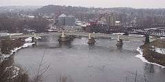
A three-way bridge called the "Y-Bridge" spans the confluence of the Licking and the Muskingum rivers. Listed on the National Register of Historic Places, it is one of very few bridges of its type in the United States. It has been rebuilt numerous times since the 1850s. Visitors to the city are often surprised when they receive directions including the statement, "Drive to the middle of the bridge and turn right." New York City's Triborough Bridge spanning the confluence of the East River, Harlem River, and Bronx Kill has some topographic similarities to the Y Bridge, but it consists of three separate bridges which meet at an island junction in the middle of the water.
Government
The city government is a Mayor/Council (10 members) elected form of government. Zanesville Police Department was formed in 1865 with 6 officers. Today the department has over 55 officers and 40 more support staff. The City Fire Department became fully paid staff in 1879. This department today has over 45 members working 24 on & 48 hours off, staffing 3 stations.
Education
Education
- The first school house (a log-cabin) was built and opened in Zanesville in 1803. Zanesville High School is the high school for the Zanesville City Schools.
- Most students living within Zanesville city limits attend Zanesville City Schools, however students with Zanesville addresses but living outside of the city limits may attend Tri-Valley High School, John Glenn High School, West Muskingum High School, Maysville High School, and Philo High School.
- There are two private high schools−Bishop Rosecrans High School (Roman Catholic) and Zanesville Christian School.
College
- Ohio University-Zanesville (OUZ) is a branch campus of Ohio University. The branch was in the high school building from 1946 until the current campus opened in 1969.
- Zane State College, formerly known as Muskingum Area Technical College, is adjacent to OUZ founded in 1969.
- Muskingum University is located in nearby New Concord.
Library
- Zanesville is served by the Muskingum County Library System.
Notable people
- Kurt Abbott, major league baseball player[18]
- Richard Basehart, actor, narrator of closing ceremonies for 1984 Summer Olympics
- Thomas Townsend Brown, inventor working on a purported anti-gravity devices and part-time researcher in unidentified flying objects
- Elwood Bruner, Alaska territorial and California state legislator
- Catharinus P. Buckingham, American Civil War general in the Union army
- Una Mae Carlisle, jazz singer, pianist, songwriter[19]
- Samuel S. Cox, U.S. Congressman and U.S. Ambassador to the Ottoman Empire[20]
- Mark Dantonio College Football Coach
- James M. Gaylord, U.S. Representative from Ohio[21]
- Cass Gilbert, architect[22]
- Charles Champion Gilbert, Union army general
- David Graf (1950-2001), actor
- Robert S. Granger, Union army general
- Zane Grey, best-selling author, film pioneer
- Charles E. Hazlett, Union lieutenant and notable participant at Gettysburg
- Clarence Jones, professional baseball player
- Richard Kelly, pioneer of architectural lighting design.[23]
- Sister Mary Aquinas Kinskey, OSF, teacher and aviator, born in Zanesville
- Mortimer D. Leggett, Union army general and superintendent of Zanesville schools
- Kevin Martin, professional basketball player[24]
- Ralph D. Mershon, electrical engineer and OSU benefactor
- Hal Naragon, professional baseball player
- Dan Patrick, radio personality, TV sportscaster
- Jay Payton, professional baseball player[25]
- Michele Redman, professional golfer
- Frederick Hurten Rhead, potter
- Kim Richey, singer/songwriter, born 1956
- Thomas Shelton, Southern Gospel musician
- Chad Stewart, rock drummer
- Fred R. Taylor, basketball coach
- William Frederick "Whitey" Wietelmann (1919-2002), major league baseball player
- Jesse Yarnell, founded Los Angeles Mirror newspaper
In popular culture
- In 1966, a reported UFO sighting was made by Zanesville barber Ralph Ditter. The photos spread around the country and the world. In addition, they were even published in various magazines, such as Mechanics Illustrated. However, these photos were later proven to be a hoax.
- In the 1979 episode "The Young and the Restless" of the TV Series M*A*S*H, Corporal Klinger (played by Jamie Farr), a Toledo, Ohio native, wears a T-shirt that says "Toledo: Gateway to Zanesville".
- In 1988, the first "Herda Fest" was held in Adamsville, OH which is a few miles East of Zanesville. This event marked the beginning of an annual ritual still held today for elementary students who are starting High School in the fall.
- The book Friday Night Lights: A Town, a Team, and a Dream cites that the founders of Odessa, Texas were originally from Zanesville.[26]
- In the episode Of Tiny Toon Adventures, Sawdust and Toonsil, Babs, Buster, and Plucky are left stranded by GoGo Dodo in a rural area marked with a sign saying: Zainsville Ohio Pop. 10.
- In Australia, the Seven Network's reality television series The World's Strictest Parents featured Aza and Troy visiting the McDonald family from Zanesville, Ohio.[27]
- In 2012, Zanesville Athletic FC was founded. Zanesville Athletic will play in the National Premier Soccer League (NPSL) starting in May 2013. They are members of the Midwest Great Lakes Conference. The home field is located in South Zanesville at the Maysville Athletic Complex (MAC) on the campus of Maysville Local School District.
- In 2013, The webcomic Broodhollow makes mention of Zanesville as a town founded by the main character Wadsworth Zane's ancestors.
References
- 1 2 "US Gazetteer files 2010". United States Census Bureau. Archived from the original on January 24, 2012. Retrieved 2013-01-06.
- 1 2 "US Board on Geographic Names". United States Geological Survey. 2007-10-25. Retrieved 2008-01-31.
- 1 2 "American FactFinder". United States Census Bureau. Retrieved 2013-01-06.
- ↑ "Population Estimates". United States Census Bureau. Archived from the original on June 17, 2013. Retrieved 2013-06-17.
- ↑ "FIPS Common Codes for Ohio". Retrieved 8 May 2012.
- ↑ "Find a County". National Association of Counties. Archived from the original on May 31, 2011. Retrieved 2011-06-07.
- ↑ http://columbia.tfd.com/Zanesville.
- ↑ "US Gazetteer files: 2010, 2000, and 1990". United States Census Bureau. 2011-02-12. Retrieved 2011-04-23.
- ↑ "Level III Ecoregions of Ohio". National Health and Environmental Effects Research Laboratory. U.S. Environmental Protection Agency. Retrieved 28 September 2013.
- ↑ "Station Name: OH ZANESVILLE MUNI AP". National Oceanic and Atmospheric Administration. Retrieved 2013-06-28.
- ↑ "Annual Estimates of the Resident Population for Incorporated Places: April 1, 2010 to July 1, 2015". Retrieved July 2, 2016.
- ↑ "Number of Inhabitants: Ohio" (PDF). 18th Census of the United States. U.S. Census Bureau. Retrieved 22 November 2013.
- ↑ "Ohio: Population and Housing Unit Counts" (PDF). U.S. Census Bureau. Retrieved 22 November 2013.
- 1 2 "American FactFinder". United States Census Bureau. Archived from the original on September 11, 2013. Retrieved 2008-01-31.
- ↑ "Incorporated Places and Minor Civil Divisions Datasets: Subcounty Population Estimates: April 1, 2010 to July 1, 2012". U.S. Census Bureau. Archived from the original on June 17, 2013. Retrieved 25 November 2013.
- ↑ "City of Lost Boundaries", Jet, Nov 22, 1951
- ↑ City of Zanesville Website, accessed February 15, 2008.
- ↑ "Kurt Abott". Baseball-Reference.com. Retrieved December 21, 2012.
- ↑ "Carlisle, Una Mae (1915 - 1956), Songwriters, Jazz Musicians, Jazz Singers, Pianists". oxfordindex.oup.com. Oxford University Press. Retrieved 25 March 2015.
- ↑ "COX, Samuel Sullivan, (1824 - 1889)". Biographical Directory of the United States Congress. Retrieved December 21, 2012.
- ↑ "GAYLORD, James Madison, (1811 - 1874)". Biographical Directory of the United States Congress. Retrieved December 21, 2012.
- ↑ "Study for Woolworth Building, New York". World Digital Library. 1910-12-10. Retrieved 2013-07-25.
- ↑ "Richard Kelly: Defining a Modern Architecture of Light" (PDF). ERCO Lichtbericht. Retrieved August 18, 2015.
- ↑ "Kevin Martin". Basketball=Reference.com. Retrieved December 21, 2012.
- ↑ "Jay Payton". Baseball-Reference.com. Retrieved December 21, 2012.
- ↑ Bissinger, H G. Friday Night Lights: A Town, a Team, and a Dream. Reading, Mass: Addison-Wesley Pub. Co, 1990. Print.
- ↑ World's Strictest Parents
External links
- City website
- Zanesville Ohio Community Directory
- Zanesville Tourism site
- Zanesville-Muskingum County Chamber of Commerce
- Downtown Zanesville Artist Colony website
Municipalities and communities of Muskingum County, Ohio, United States | ||
|---|---|---|
| City |  | |
| Villages | ||
| Townships | ||
| CDPs | ||
| Unincorporated communities |
| |
| Footnotes | ‡This populated place also has portions in an adjacent county or counties | |