Yuma County, Arizona
| Yuma County, Arizona | |
|---|---|
 Yuma County Courthouse | |
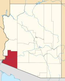 Location in the U.S. state of Arizona | |
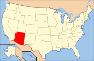 Arizona's location in the U.S. | |
| Founded | November 9, 1864 |
| Seat | Yuma |
| Largest city | Yuma |
| Area | |
| • Total | 5,519 sq mi (14,294 km2) |
| • Land | 5,514 sq mi (14,281 km2) |
| • Water | 5.1 sq mi (13 km2), 0.09% |
| Population (est.) | |
| • (2015) | 204,275 |
| • Density | 37/sq mi (14/km²) |
| Congressional districts | 3rd, 4th |
| Time zone | Mountain: UTC-7 |
| Website |
www |
Yuma County is a county located in the southwestern corner of the U.S. state of Arizona. As of the 2010 census, its population was 195,751.[1] The county seat is Yuma.[2]
Yuma County comprises the Yuma, AZ Metropolitan Statistical Area.
The county borders the Colorado River to the southwest, with three other states across the river: California and the Mexican states of Baja California and Sonora.
History
Yuma County was the one of four original Arizona Counties created by the 1st Arizona Territorial Legislature. The county territory was defined as being west of longitude 113° 20' and south of the Bill Williams River.[3] Its original boundaries remained the same until 1982, when La Paz County was created from its northern half.
The original county seat was the city of La Paz until 1871 when it was moved to Arizona City, later renamed Yuma in 1873.[4]
Geography
According to the U.S. Census Bureau, the county has a total area of 5,519 square miles (14,290 km2), of which 5,514 square miles (14,280 km2) is land and 5.1 square miles (13 km2) (0.09%) is water.[5] The lowest point in the state of Arizona is located on the Colorado River in San Luis in Yuma County, where it flows out of Arizona and into Sonora in Mexico.
Because of its location along the U.S.-Mexico border, large numbers of illegal aliens entering the United States illegally pass through Yuma County. From October to July 2005, some 124,400 illegal foreign nationals were apprehended in the area, a 46% increase on the previous year (Economist, August 27, 2005).
Yuma County is in the west, and northwestern regions of the north-south Sonoran Desert that extends through Sonora state Mexico to the border of northern Sinaloa state. West of the county across the Colorado River in southeast California is the Colorado Desert, (a northwestern subregion of the Sonoran Desert). North of the county, with La Paz County the regions merge into the southeastern Mojave Desert. Southwest of Yuma County, is the entirety of Northwest Mexico, at the north shoreline of the Gulf of California, and the outlet of the Colorado River into the Colorado River Delta region, now altered with lack of freshwater inputs. Notable mountains in Yuma County include the Gila Mountains and the Tule Mountains.
Adjacent counties and municipalities
- La Paz County - north
- Maricopa County - northeast
- Pima County - east
- Municipality of Mexicali, Baja California, Mexico - west
- San Luis Rio Colorado, Sonora, Mexico - south
- Puerto Peñasco, Sonora, Mexico - south
- Plutarco Elías Calles, Sonora, Mexico - south
- Imperial County, California - west
- Riverside County, California - west/northwest
- San Bernardino County, California - northwest
Major highways
National protected areas
- Cabeza Prieta National Wildlife Refuge (part)
- Imperial National Wildlife Refuge (part)
- Kofa National Wildlife Refuge (part)
Climate
| Climate data for Yuma, Arizona (Yuma Int'l), 1981–2010 normals,[lower-alpha 1] extremes 1878–present | |||||||||||||
|---|---|---|---|---|---|---|---|---|---|---|---|---|---|
| Month | Jan | Feb | Mar | Apr | May | Jun | Jul | Aug | Sep | Oct | Nov | Dec | Year |
| Record high °F (°C) | 88 (31) |
97 (36) |
102 (39) |
107 (42) |
120 (49) |
122 (50) |
124 (51) |
120 (49) |
123 (51) |
112 (44) |
98 (37) |
91 (33) |
124 (51) |
| Mean maximum °F (°C) | 79.4 (26.3) |
85.0 (29.4) |
92.9 (33.8) |
100.0 (37.8) |
106.8 (41.6) |
112.6 (44.8) |
114.7 (45.9) |
114.3 (45.7) |
110.8 (43.8) |
102.1 (38.9) |
89.1 (31.7) |
77.8 (25.4) |
116.2 (46.8) |
| Average high °F (°C) | 69.6 (20.9) |
73.8 (23.2) |
79.9 (26.6) |
86.4 (30.2) |
95.3 (35.2) |
103.5 (39.7) |
106.8 (41.6) |
106.2 (41.2) |
101.3 (38.5) |
89.9 (32.2) |
77.5 (25.3) |
68.3 (20.2) |
88.2 (31.2) |
| Average low °F (°C) | 47.6 (8.7) |
50.1 (10.1) |
54.4 (12.4) |
59.6 (15.3) |
67.3 (19.6) |
74.6 (23.7) |
82.1 (27.8) |
82.3 (27.9) |
76.5 (24.7) |
65.0 (18.3) |
53.9 (12.2) |
46.6 (8.1) |
63.3 (17.4) |
| Mean minimum °F (°C) | 37.3 (2.9) |
39.7 (4.3) |
43.9 (6.6) |
49.1 (9.5) |
56.4 (13.6) |
64.3 (17.9) |
74.1 (23.4) |
73.6 (23.1) |
65.3 (18.5) |
54.2 (12.3) |
43.1 (6.2) |
36.4 (2.4) |
34.6 (1.4) |
| Record low °F (°C) | 22 (−6) |
25 (−4) |
31 (−1) |
38 (3) |
39 (4) |
50 (10) |
61 (16) |
58 (14) |
50 (10) |
35 (2) |
29 (−2) |
22 (−6) |
22 (−6) |
| Average precipitation inches (mm) | 0.36 (9.1) |
0.33 (8.4) |
0.34 (8.6) |
0.12 (3) |
0.03 (0.8) |
0.01 (0.3) |
0.26 (6.6) |
0.52 (13.2) |
0.53 (13.5) |
0.21 (5.3) |
0.20 (5.1) |
0.45 (11.4) |
3.36 (85.3) |
| Average precipitation days (≥ 0.01 in) | 2.3 | 2.0 | 1.8 | .8 | .4 | .2 | .9 | 2.3 | 1.2 | 1.1 | 1.0 | 2.1 | 16.2 |
| Mean monthly sunshine hours | 268.4 | 270.8 | 335.5 | 365.5 | 407.4 | 415.4 | 392.6 | 375.6 | 341.7 | 319.6 | 270.1 | 252.7 | 4,015.3 |
| Percent possible sunshine | 84 | 88 | 90 | 94 | 95 | 97 | 90 | 91 | 92 | 91 | 86 | 81 | 90 |
| Source: NOAA[6][7] | |||||||||||||
Demographics
| Historical population | |||
|---|---|---|---|
| Census | Pop. | %± | |
| 1870 | 1,621 | — | |
| 1880 | 3,215 | 98.3% | |
| 1890 | 2,671 | −16.9% | |
| 1900 | 4,145 | 55.2% | |
| 1910 | 7,733 | 86.6% | |
| 1920 | 14,904 | 92.7% | |
| 1930 | 17,816 | 19.5% | |
| 1940 | 19,326 | 8.5% | |
| 1950 | 28,006 | 44.9% | |
| 1960 | 46,235 | 65.1% | |
| 1970 | 60,827 | 31.6% | |
| 1980 | 90,554 | 48.9% | |
| 1990 | 106,895 | 18.0% | |
| 2000 | 160,026 | 49.7% | |
| 2010 | 195,751 | 22.3% | |
| Est. 2015 | 204,275 | [8] | 4.4% |
| U.S. Decennial Census[9] 1790–1960[10] 1900–1990[11] 1990–2000[12] 2010–2015[1] | |||
2000 census
As of the 2000 census, there were 160,026 people, 53,848 households, and 41,678 families residing in the county. The population density was 29 people per square mile (11/km²). There were 74,140 housing units at an average density of 13 per square mile (5/km²). The racial makeup of the county was 68.3% White, 2.2% Black or African American, 1.6% Native American, 0.9% Asian, 0.1% Pacific Islander, 23.6% from other races, and 3.2% from two or more races. 50.5% of the population were Hispanic or Latino of any race. 43.7% reported speaking Spanish at home .
There were 53,848 households out of which 36.9% had children under the age of 18 living with them, 62.3% were married couples living together, 11.2% had a female householder with no husband present, and 22.6% were non-families. 18.5% of all households were made up of individuals and 8.9% had someone living alone who was 65 years of age or older. The average household size was 2.86 and the average family size was 3.27.
In the county the population was spread out with 28.9% under the age of 18, 10.0% from 18 to 24, 25.6% from 25 to 44, 18.9% from 45 to 64, and 16.5% who were 65 years of age or older. The median age was 34 years. For every 100 females there were 102.00 males. For every 100 females age 18 and over, there were 101.10 males.
The median income for a household in the county was $32,182, and the median income for a family was $34,659. Males had a median income of $27,390 versus $22,276 for females. The per capita income for the county was $14,802. About 15.5% of families and 19.2% of the population were below the poverty line, including 27.9% of those under age 18 and 8.7% of those age 65 or over.
2010 census
As of the 2010 United States Census, there were 195,751 people, 64,767 households, and 48,976 families residing in the county.[13] The population density was 35.5 inhabitants per square mile (13.7/km2). There were 87,850 housing units at an average density of 15.9 per square mile (6.1/km2).[14] The racial makeup of the county was 70.4% white, 2.0% black or African American, 1.6% American Indian, 1.2% Asian, 0.2% Pacific islander, 20.8% from other races, and 3.8% from two or more races. Those of Hispanic or Latino origin made up 59.7% of the population.[13] In terms of ancestry, 10.6% were German, 7.4% were English, 6.9% were Irish, and 3.2% were American.[15]
Of the 64,767 households, 41.1% had children under the age of 18 living with them, 56.8% were married couples living together, 13.8% had a female householder with no husband present, 24.4% were non-families, and 19.6% of all households were made up of individuals. The average household size was 2.93 and the average family size was 3.39. The median age was 33.8 years.[13]
The median income for a household in the county was $40,340 and the median income for a family was $42,718. Males had a median income of $36,345 versus $27,262 for females. The per capita income for the county was $18,418. About 17.6% of families and 20.9% of the population were below the poverty line, including 30.7% of those under age 18 and 12.7% of those age 65 or over.[16]
Government
Of the several departments and services of Yuma County government,[17] the Board of Supervisors is the governing body of the county and a number of special districts. The Board adopts ordinances, establishes programs, levies taxes, appropriates funds, appoints certain officials, and zones property and regulates development in the unincorporated area. In addition, members of the Board represent the County on numerous intergovernmental agencies.
Communities

Cities
Town
Census-designated places
- Avenue B and C
- Aztec
- Buckshot
- Dateland
- Donovan Estates
- Drysdale
- El Prado Estates
- Fortuna Foothills
- Gadsden
- Martinez Lake
- Orange Grove Mobile Manor
- Padre Ranchitos
- Rancho Mesa Verde
- Tacna
- Wall Lane
- Wellton Hills
Unincorporated communities
Ghost towns
County population ranking
The population ranking of the following table is based on the 2010 census of Yuma County.[18][19]
† county seat
| Rank | City/Town/etc. | Population (2010 Census) | Municipal type | Incorporated |
|---|---|---|---|---|
| 1 | † Yuma | 93,064 | City | 1914 |
| 2 | Fortuna Foothills | 26,265 | CDP | |
| 3 | San Luis | 25,505 | City | 1979 |
| 4 | Somerton | 14,287 | City | |
| 5 | Avenue B and C | 4,176 | CDP | |
| 6 | Wellton | 2,882 | Town | 1970 |
| 7 | Donovan Estates | 1,508 | CDP | |
| 8 | Martinez Lake | 798 | CDP | |
| 9 | Gadsden | 678 | CDP | |
| 10 | Rancho Mesa Verde | 625 | CDP | |
| 11 | Tacna | 602 | CDP | |
| 12 | Orange Grove Mobile Manor | 594 | CDP | |
| 13 | El Prado Estates | 504 | CDP | |
| 14 | Dateland | 416 | CDP | |
| 15 | Wall Lane | 415 | CDP | |
| 16 | Drysdale | 272 | CDP | |
| 17 | Wellton Hills | 258 | CDP | |
| 18 | Padre Ranchitos | 171 | CDP | |
| 19 | Buckshot | 153 | CDP | |
| 20 | Aztec | 47 | CDP |
See also
Notes
- ↑ Mean monthly maxima and minima (i.e. the highest and lowest temperature readings during an entire month or year) calculated based on data at said location from 1981 to 2010.
References
- Specific
- 1 2 "State & County QuickFacts". United States Census Bureau. Retrieved May 18, 2014.
- ↑ "Find a County". National Association of Counties. Archived from the original on May 31, 2011. Retrieved 2011-06-07.
- ↑ Wagoner, Jay J. (1970). Arizona Territory 1863-1912: A Political history. Tucson: University of Arizona Press. p. 58. ISBN 0-8165-0176-9.
- ↑ Walker, Henry (1986). "Historical Atlas of Arizona", p.32. University of Oklahoma Press, Norman. ISBN 978-0-8061-2024-9
- ↑ "2010 Census Gazetteer Files". United States Census Bureau. August 23, 2012. Retrieved August 23, 2015.
- ↑ "NOWData - NOAA Online Weather Data". National Weather Service. Retrieved 2012-12-02.
- ↑ "FTP NOAA Weather Data file". National Oceanic and Atmospheric Administration. Retrieved 2016-04-12.
- ↑ "County Totals Dataset: Population, Population Change and Estimated Components of Population Change: April 1, 2010 to July 1, 2015". Retrieved July 2, 2016.
- ↑ "U.S. Decennial Census". United States Census Bureau. Archived from the original on May 11, 2015. Retrieved May 18, 2014.
- ↑ "Historical Census Browser". University of Virginia Library. Retrieved May 18, 2014.
- ↑ "Population of Counties by Decennial Census: 1900 to 1990". United States Census Bureau. Retrieved May 18, 2014.
- ↑ "Census 2000 PHC-T-4. Ranking Tables for Counties: 1990 and 2000" (PDF). United States Census Bureau. Retrieved May 18, 2014.
- 1 2 3 "DP-1 Profile of General Population and Housing Characteristics: 2010 Demographic Profile Data". United States Census Bureau. Retrieved 2016-01-20.
- ↑ "Population, Housing Units, Area, and Density: 2010 - County". United States Census Bureau. Retrieved 2016-01-20.
- ↑ "DP02 SELECTED SOCIAL CHARACTERISTICS IN THE UNITED STATES – 2006-2010 American Community Survey 5-Year Estimates". United States Census Bureau. Retrieved 2016-01-20.
- ↑ "DP03 SELECTED ECONOMIC CHARACTERISTICS – 2006-2010 American Community Survey 5-Year Estimates". United States Census Bureau. Retrieved 2016-01-20.
- ↑ http://www.yumacountyaz.gov | Yuma County, Departments and Services
- ↑ "Archived copy". Archived from the original on December 21, 2013. Retrieved February 13, 2016.
- ↑ http://www.census.gov/geo/maps-data/maps/block/2010/
- General
- "Cross-Border, Cross-Purposes". The Economist. August 27-September 2, 2005.
External links
- Yuma County official web site
 Geographic data related to Yuma County, Arizona at OpenStreetMap
 |
Imperial County, California | La Paz County | | |
| Municipality of Mexicali | |
Maricopa County Pima County | ||
| ||||
| | ||||
| State of Sonora, Mexico |
Municipalities and communities of Yuma County, Arizona, United States | ||
|---|---|---|
| Cities | | |
| Town | ||
| CDPs |
| |
| Unincorporated communities | ||
| Indian reservations | ||
| Ghost towns | ||
| Footnotes | ‡This populated place also has portions in an adjacent county or counties | |
Coordinates: 32°47′13″N 113°58′58″W / 32.78694°N 113.98278°W