Yes Tor
| Yes Tor | |
|---|---|
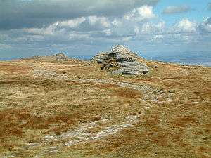 Yes Tor (left, beyond) with High Willhays in the front | |
| Highest point | |
| Elevation | 619 m (2,031 ft) |
| Prominence | 24 m (79 ft) [1] |
| Listing | Nuttall |
| Coordinates | 50°41′35″N 4°00′43″W / 50.69317°N 4.01182°WCoordinates: 50°41′35″N 4°00′43″W / 50.69317°N 4.01182°W |
| Geography | |
 Yes Tor Yes Tor in Devon | |
| Location | Dartmoor, England |
| OS grid | SX580901 |
| Topo map | OS Landranger 191 |
Yes Tor is the second highest point on Dartmoor, Devon, South West England, at 619 metres (2,031 ft) above sea level. It is one of only two wholly English peaks south of the Peak District National Park—the other being nearby High Willhays—that are above 2,000 feet (610 m).
It lies within a British Army firing range and safe access is only possible on days or nights when firing is not taking place. See the current Dartmoor Firing Notice.[2]
Yes Tor is 2 metres (7 feet) lower than the nearby High Willhays.
A notable mine is located in the area.
In literature
In his memoir Father and Son (1907), Edmund Gosse views Yes Tor, near which he lived when a boy, as an unthreatening and unprepossessing hill: "Alas! We might as well have attempted to rouse the summit of Yes Tor into volcanic action."
In popular culture
Yes Tor was the original inspiration for the name of the Yes album Tormato and a picture of the Tor features on the album cover.
US science fiction author Kim Stanley Robinson makes an oblique reference to Yes Tor in his novel 2312, commingled with a variety of then-historical musical contextual clues.
References
External links
![]() Media related to Yes Tor at Wikimedia Commons
Media related to Yes Tor at Wikimedia Commons