Yates County, New York
| Yates County, New York | |
|---|---|
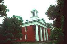 Yates County Courthouse | |
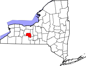 Location in the U.S. state of New York | |
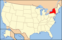 New York's location in the U.S. | |
| Founded | February 5, 1823 |
| Named for | Joseph C. Yates |
| Seat | Penn Yan |
| Largest town | Milo |
| Area | |
| • Total | 376 sq mi (974 km2) |
| • Land | 338 sq mi (875 km2) |
| • Water | 38 sq mi (98 km2), 10% |
| Population | |
| • (2010) | 25,348 |
| • Density | 75/sq mi (29/km²) |
| Congressional district | 23rd |
| Time zone | Eastern: UTC-5/-4 |
| Website |
www |
Yates County is a county located in the U.S. state of New York. As of the 2010 census, the population was 25,348,[1] making it the third-least populous county in New York. The county seat is Penn Yan.[2] The name is in honor of Joseph C. Yates, who as Governor of New York signed the act establishing the county.
Yates County is included in the Rochester, NY Metropolitan Statistical Area.
History
When counties were established in New York State in 1683, the present Yates County was part of Albany County. This was an enormous county, including the northern part of New York State as well as all of the present State of Vermont and, in theory, extending westward to the Pacific Ocean. This county was reduced in size on July 3, 1766 by the creation of Cumberland County, and further on March 16, 1770 by the creation of Gloucester County, both containing territory now in Vermont.
On March 12, 1772, what was left of Albany County was split into three parts, one remaining under the name Albany County. One of the other pieces, Tryon County, contained the western portion (and thus, since no western boundary was specified, theoretically still extended west to the Pacific). The eastern boundary of Tryon County was approximately five miles west of the present city of Schenectady, and the county included the western part of the Adirondack Mountains and the area west of the West Branch of the Delaware River. The area then designated as Tryon County now includes 37 counties of New York State. The county was named for William Tryon, colonial governor of New York.
In the years prior to 1776, most of the Loyalists in Tryon County fled to Canada. In 1784, following the peace treaty that ended the American Revolutionary War, the name of Tryon County was changed to honor the general, Richard Montgomery, who had captured several places in Canada and died attempting to capture the city of Quebec, replacing the name of the hated British governor.
On January 27, 1789, 10,480 square miles (27,140 km2) of Montgomery County was split off to create Ontario County, including the lands of the present Allegany, Cattaraugus, Chautauqua, Erie, Genesee, Livingston, Monroe, Niagara, Orleans, Steuben, Wyoming, and Yates counties, and part of Schuyler and Wayne counties.
On March 18, 1796, 1,800 square miles (4,700 km2) of Ontario County was partitioned to form Steuben County.
On April 3, 1801, Ontario County exchanged land with Cayuga County, and lost 190 square miles (490 km2) as a result.
On March 30, 1802, Ontario County lost 6,540 square miles (16,940 km2) of land through the partition of Genesee County, including the present Allegany, Cattaraugus, Chautauqua, Erie, Niagara, Orleans and Wyoming counties and parts of Livingston and Monroe counties.
In 1821, Ontario County was reduced in size by combining portions of Genesee and Ontario counties to create Livingston and Monroe counties.
On February 5, 1823, Yates County was formed from 310 square miles (800 km2) of Ontario County, including the area that included Vine Valley, Middlesex, Penn Yan, and Dresden, New York.[3]
On January 1, 1826, 60 square miles (160 km2) of Steuben County was partitioned and added to Yates, which included Starkey, Dundee, and Lakemont, New York.[4]
On April 15, 1828, 10 square miles (26 km2) was partitioned from Yates, and passed to Seneca and Tompkins counties, mostly in the forest.[5]
On March 17, 1860, Ontario County was authorized to gain land from Yates, but it was never put into effect.[6]
On April 18, 1946, Yates gained 10 square miles (26 km2) from Schuyler and Senaca counties, which produced the current borders of Yates County.[7]
Geography
According to the U.S. Census Bureau, the county has a total area of 376 square miles (970 km2), of which 338 square miles (880 km2) is land and 38 square miles (98 km2) (10%) is water.[8]
Yates County is in the western part of New York State, northwest of Ithaca and southeast of Rochester. It is in the Finger Lakes Region.
Adjacent counties
- Ontario County - northwest
- Seneca County - east
- Schuyler County - south
- Steuben County - southwest
Demographics
| Historical population | |||
|---|---|---|---|
| Census | Pop. | %± | |
| 1830 | 19,009 | — | |
| 1840 | 20,444 | 7.5% | |
| 1850 | 20,590 | 0.7% | |
| 1860 | 20,290 | −1.5% | |
| 1870 | 19,595 | −3.4% | |
| 1880 | 21,087 | 7.6% | |
| 1890 | 21,001 | −0.4% | |
| 1900 | 20,318 | −3.3% | |
| 1910 | 18,642 | −8.2% | |
| 1920 | 16,641 | −10.7% | |
| 1930 | 16,848 | 1.2% | |
| 1940 | 16,381 | −2.8% | |
| 1950 | 17,615 | 7.5% | |
| 1960 | 18,614 | 5.7% | |
| 1970 | 19,831 | 6.5% | |
| 1980 | 21,459 | 8.2% | |
| 1990 | 22,810 | 6.3% | |
| 2000 | 24,621 | 7.9% | |
| 2010 | 25,348 | 3.0% | |
| Est. 2015 | 25,048 | [9] | −1.2% |
| U.S. Decennial Census[10] 1790-1960[11] 1900-1990[12] 1990-2000[13] 2010-2013[1] | |||
As of the census[14] of 2000, there were 24,621 people, 9,029 households, and 6,284 families residing in the county. The population density was 73 people per square mile (28/km²). There were 12,064 housing units at an average density of 36 per square mile (14/km²). The racial makeup of the county was 97.90% White, 0.56% African American, 0.15% Native American, 0.28% Asian, 0.02% Pacific Islander, 0.36% from other races, and 0.74% from two or more races. Hispanic or Latino of any race were 0.93% of the population. 21.3% were of English, 16.5% German, 11.4% Irish, 10.7% American, 5.3% Danish and 5.3% Italian ancestry according to Census 2000.
5.46% of the population over 5 years old, mostly Wenger Old Order Mennonites,[15] report speaking Pennsylvania German, German, or Dutch at home, a further 1.54% speak Spanish.
There were 9,029 households out of which 31.50% had children under the age of 18 living with them, 56.00% were married couples living together, 9.40% had a female householder with no husband present, and 30.40% were non-families. 24.60% of all households were made up of individuals and 11.60% had someone living alone who was 65 years of age or older. The average household size was 2.59 and the average family size was 3.08.
In the county the population was spread out with 26.70% under the age of 18, 9.30% from 18 to 24, 24.70% from 25 to 44, 23.90% from 45 to 64, and 15.50% who were 65 years of age or older. The median age was 38 years. For every 100 females there were 95.30 males. For every 100 females age 18 and over, there were 91.30 males.
The median income for a household in the county was $34,640, and the median income for a family was $40,681. Males had a median income of $29,671 versus $21,566 for females. The per capita income for the county was $16,781. About 8.90% of families and 13.10% of the population were below the poverty line, including 20.90% of those under age 18 and 7.10% of those age 65 or over.
Education
Keuka College is in this county.
Transportation
Major highways
 New York State Route 14
 New York State Route 14A
 New York State Route 54
 New York State Route 54A
 New York State Route 245
 New York State Route 364
Airport
Penn Yan Airport (PEO), the principal airport in the county, is on a hill south of Penn Yan.
Communities
Towns
Villages
Census-designated place
Hamlets
- Bellona
- Branchport
- Glenora
- Lakemont
See also
- List of counties in New York
- National Register of Historic Places listings in Yates County, New York
- The Bluff Point Stoneworks
References
- 1 2 "State & County QuickFacts". United States Census Bureau. Retrieved October 13, 2013.
- ↑ "Find a County". National Association of Counties. Retrieved 2011-06-07.
- ↑ New York. Laws of New York.1823, 46th Session, Chapter 30, Section 1; Page 21
- ↑ New York. Laws of New York.1824, 47th Session, Chapter 171; Page 182
- ↑ New York. Revised Statutes of the State of New York, Passed during the years 1827 and 1828; 3 Volumes; Albany, New York.1829; Volume 3;Pages 14-15
- ↑ New York. Laws of New York.1860, 83rd Session, Chapter 76; Page 120
- ↑ New York. Laws of New York.1946, 169th Session, Chapter 901; Page 1686
- ↑ "2010 Census Gazetteer Files". United States Census Bureau. August 22, 2012. Retrieved January 8, 2015.
- ↑ "County Totals Dataset: Population, Population Change and Estimated Components of Population Change: April 1, 2010 to July 1, 2015". Retrieved July 2, 2016.
- ↑ "U.S. Decennial Census". United States Census Bureau. Retrieved January 8, 2015.
- ↑ "Historical Census Browser". University of Virginia Library. Retrieved January 8, 2015.
- ↑ Forstall, Richard L., ed. (March 27, 1995). "Population of Counties by Decennial Census: 1900 to 1990". United States Census Bureau. Retrieved January 8, 2015.
- ↑ "Census 2000 PHC-T-4. Ranking Tables for Counties: 1990 and 2000" (PDF). United States Census Bureau. Retrieved January 8, 2015.
- ↑ "American FactFinder". United States Census Bureau. Retrieved 2008-01-31.
- ↑ Reid, Judson: Old Order Mennonites in New York: Cultural and Agricultural Growth, in Journal of Amish and Plain Anabaptist Studies 3(2):212, 2015, pages 107-129.
External links
- Yates County, New York
- Yates County information
- Yates County at DMOZ
- Yates County historical information
- Summary history of Yates County and its towns
 |
Ontario County | | ||
| Ontario County | |
Seneca County | ||
| ||||
| | ||||
| Steuben County | Schuyler County |
Municipalities and communities of Yates County, New York, United States | ||
|---|---|---|
| Towns | | |
| Villages | ||
| CDP | ||
| Hamlets | ||
| Footnotes | ‡This populated place also has portions in an adjacent county or counties | |
Coordinates: 42°38′N 77°06′W / 42.64°N 77.10°W