Yarka
Yarka
| ||
|---|---|---|
| Hebrew transcription(s) | ||
| • Also spelled | Yirka (unofficial) | |
|
Yarka municipality | ||
| ||
 Yarka | ||
| Coordinates: 32°57′14.39″N 35°12′44.16″E / 32.9539972°N 35.2122667°ECoordinates: 32°57′14.39″N 35°12′44.16″E / 32.9539972°N 35.2122667°E | ||
| Grid position | 170/261 PAL | |
| District | Northern | |
| Government | ||
| • Type | Local council | |
| Area | ||
| • Total | 15,564 dunams (15.564 km2 or 6.009 sq mi) | |
| Population (2015)[1] | ||
| • Total | 16,244 | |


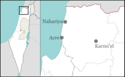
Yarka (Hebrew: יִרְכָּא, Arabic: يركا)[2] is a Druze village and local council in the Northern District of Israel. Located northeast of Acre, in 2015 it had a population of 16,244.
History
Yarka is an ancient village site, where old columns and cisterns have been found. Clermont-Ganneau found a Greek inscription here dating from the Christian era.[3] In the Crusader era, Yarka was known under the name of Arket. In 1220 Joscelin III´s daughter Beatrix de Courtenay and her husband Otto von Botenlauben, Count of Henneberg, sold their land, including Arket, to the Teutonic Knights.[4]
Ottoman era
In 1517, Yarka was with the rest of Palestine incorporated into the Ottoman Empire after it was captured from the Mamluks, and by 1596, it appeared in the Ottoman tax registers as part of the Nahiya of Akka of the Liwa of Safad. It had a population of 174 Muslim households and 24 bachelors and paid taxes on an olive press.[5][6]
A map by Pierre Jacotin from Napoleon's invasion of 1799 showed the place, named as Hierka.[7]
_in_yarka.jpg)
The French explorer Victor Guérin visited Yarka in 1875, and wrote that "cut stones of ancient appearance have been used in building the modern houses. [..] About a hundred cisterns cut in rock, a half of which are no longer used, and the other half serve for the wants of the people, reveal the existence in this place of an ancient locality of some importance."[8] In 1881, the Palestine Exploration Fund's Survey of Western Palestine, Yarka is described as a well-built stone village inhabited by 400 Druze who grew olives and figs.[9]
British Mandate era
In a census conducted in 1922 by the British Mandate authorities, Yarka had a population of 978 residents; 937 Druze, 26 Muslims and 15 Christians,[10] where the Christians were 11 Orthodox, 3 Roman Catholics and 1 Maronite.[11] The population increased in the 1931 census of Palestine to 1,196; 1,138 Druze, 46 Muslims and 11 Christians living in a total of 343 occupied houses.[12]
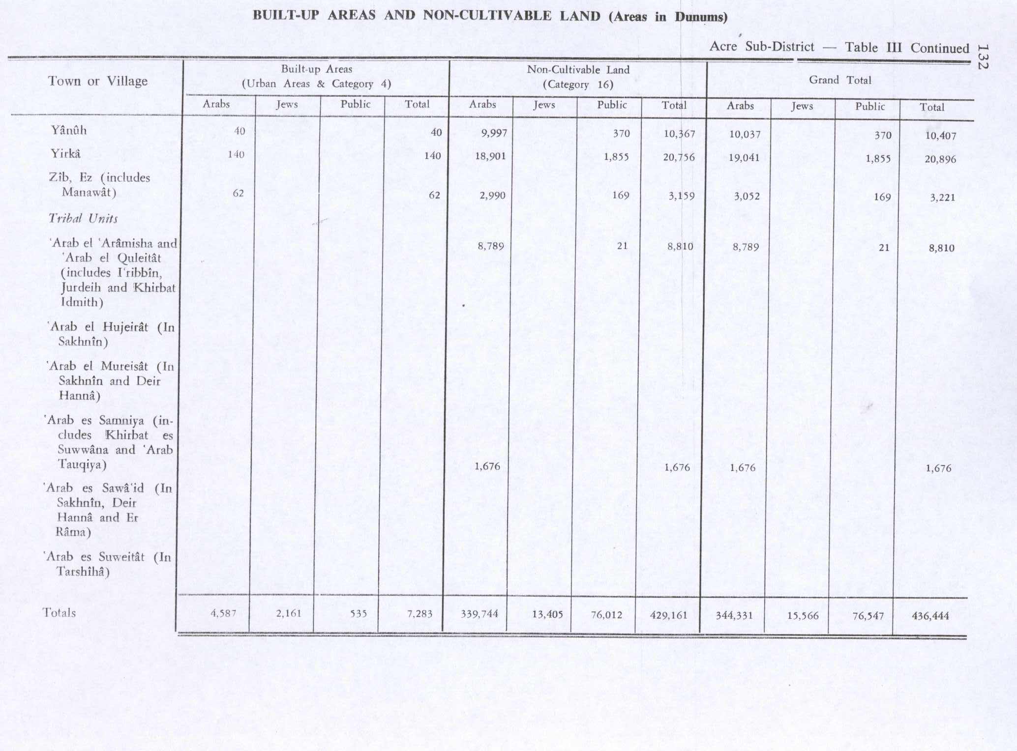
In 1945 Yirka had a population of 1,500; 70 Muslims, 10 Christians and 1420 "other" (=Druze),[13] with 42,452 dunams of land, according to an official land and population survey.[14] Of this, 5,747 dunams were plantations and irrigable land, 5,909 used for cereals,[15] while 140 dunams were built-up land.[16]
Religious sites
Yarka contains the maqam ("saintly-person tomb") of Shaykh Ghana'im Abu Saraya,[17][18] a native of the town and one of the first missionary sheikhs to spread the Druze faith in the Galilee during the 11th century.[17][19][20] He was the principle Druze sheikh in the Acre coastal area.[19] Druze tradition has it that Abu Saraya is buried underneath the floor of the shrine.[18]
The town is also the site of the al-Nabi Siddiq maqam. The Druze associate al-Nabi Siddiq with Hushai ha-Arki, an adviser to the ancient Israelite king David. According to this tradition, the name Yarka derives from "ha-Arki." The Druze prayer house Khalwah ash-Sheikh Muhammad is situated just east of Yarka. It was built sometime prior to 1931 by the religious sheikh Muhammad Mu'addi as a center for Druze religious studies.[21]
Economy
One of the largest factories in the Middle East , a steel mill built and owned by the Kadmani family, is located in Yarka. My Baby, with 11,000 meters of retail space, is Israel's largest store for children's and baby's supplies. The store has an annual turnover of NIS 100 million.[22]
References
- ↑ "List of localities, in Alphabetical order" (PDF). Israel Central Bureau of Statistics. Retrieved 16 October 2016.
- ↑ Personal name, according to Palmer, 1881, p. 60
- ↑ Dauphin, 1998, p. 639, citing Clermont-Ganneau, 1881, pp. 37-38.
- ↑ Strehlke, 1869, pp. 43- 44, No. 53; cited in Röhricht, 1893, RHH, p. 248, No. 934 (34); cited in Frankel, 1988, pp. 254, 263
- ↑ Hütteroth and Abdulfattah, 1977, p. 191
- ↑ Note that Rhode, 1979, p. 6 writes that the Safad register that Hütteroth and Abdulfattah studied was not from 1595/6, but from 1548/9
- ↑ Karmon, 1960, p. 162.
- ↑ Guérin, 1880, pp. 16-17, as translated and cited by Conder and Kitchener, 1881, SWP I, p. 193
- ↑ Conder and Kitchener, 1881, SWP I, p. 148
- ↑ Barron, 1923, Table XI, Sub-district of Acre, p. 36
- ↑ Barron, 1923, Table XVI, p. 50
- ↑ Mills, 1932, p. 103
- ↑ Department of Statistics, 1945, p. 5
- ↑ Government of Palestine, Department of Statistics. Village Statistics, April, 1945. Quoted in Hadawi, 1970, p. 41
- ↑ Government of Palestine, Department of Statistics. Village Statistics, April, 1945. Quoted in Hadawi, 1970, p. 82
- ↑ Government of Palestine, Department of Statistics. Village Statistics, April, 1945. Quoted in Hadawi, 1970, p. 132
- 1 2 Swayd, 2009, p. 8
- 1 2 Dana, 2003, p. 36.
- 1 2 Abu-Izzedin, 1993, p. 131
- ↑ Dana, 2003, p. 106.
- ↑ Dana, 2003, p. 32.
- ↑ Israel's only American-style baby store, in the heart of a Druze village
Bibliography
| Wikimedia Commons has media related to Yirka. |
- Abu Izzedin, Nejla M. (1993). The Druzes: A New Study of Their History, Faith, and Society. Leiden: Brill. ISBN 90-04-09705-8.
- Barag, Dan (1979). "A new source concerning the ultimate borders of the Latin Kingdom of Jerusalem". Israel Exploration Journal. 29: 197–217.
- Barron, J. B., ed. (1923). Palestine: Report and General Abstracts of the Census of 1922. Government of Palestine.
- Clermont-Ganneau, Charles Simon (1881). "Note IV by Clermont-Ganneau". Quarterly statement - Palestine Exploration Fund. 13: 37–38.
- Conder, Claude Reignier; Kitchener, Herbert H. (1881). The Survey of Western Palestine: Memoirs of the Topography, Orography, Hydrography, and Archaeology. 1. London: Committee of the Palestine Exploration Fund. (p. 152)
- Dana, Nissim (2003). The Druze in the Middle East: Their Faith, Leadership, Identity and Status. Sussex Academic Press. ISBN 1903900360.
- Dauphin, Claudine (1998). La Palestine byzantine, Peuplement et Populations. BAR International Series 726 (in French). III : Catalogue. Oxford: Archeopress. ISBN 0-860549-05-4.
- Department of Statistics (1945). Village Statistics, April, 1945. Government of Palestine.
- Frankel, Rafael (1988). "Topographical notes on the territory of Acre in the Crusader period". Israel Exploration Journal. 38 (4): 249–272.
- Guérin, Victor (1880). Description Géographique Historique et Archéologique de la Palestine (in French). 3: Galilee, pt. 2. Paris: L'Imprimerie Nationale.
- Hadawi, Sami (1970). Village Statistics of 1945: A Classification of Land and Area ownership in Palestine. Palestine Liberation Organization Research Center.
- Hütteroth, Wolf-Dieter; Abdulfattah, Kamal (1977). Historical Geography of Palestine, Transjordan and Southern Syria in the Late 16th Century. Erlanger Geographische Arbeiten, Sonderband 5. Erlangen, Germany: Vorstand der Fränkischen Geographischen Gesellschaft. ISBN 3-920405-41-2.
- Karmon, Y. (1960). "An Analysis of Jacotin's Map of Palestine" (PDF). Israel Exploration Journal. 10 (3,4): 155–173; 244–253.
- Mills, E., ed. (1932). Census of Palestine 1931. Population of Villages, Towns and Administrative Areas (PDF). Jerusalem: Government of Palestine.
- Palmer, E. H. (1881). The Survey of Western Palestine: Arabic and English Name Lists Collected During the Survey by Lieutenants Conder and Kitchener, R. E. Transliterated and Explained by E.H. Palmer. Committee of the Palestine Exploration Fund.
- Rhode, Harold (1979). Administration and Population of the Sancak of Safed in the Sixteenth Century. Columbia University.
- Röhricht, Reinhold (1893). (RRH) Regesta regni Hierosolymitani (MXCVII-MCCXCI) (in Latin). Berlin: Libraria Academica Wageriana.
- Strehlke, Ernst, ed. (1869). Tabulae Ordinis Theutonici ex tabularii regii Berolinensis codice potissimum. Berlin: Weidmanns.
- Swayd, Sami (2009). The A to Z of the Druzes. Rowman & Littlefield. ISBN 0810868369.
- Thomson, William McClure (1859). The Land and the Book: Or, Biblical Illustrations Drawn from the Manners and Customs, the Scenes and Scenery, of the Holy Land. 1 (1 ed.). New York: Harper & brothers. (p. 463)
External links
- Official website
- Welcome To Yirka
- Survey of Western Palestine, Map 3: IAA, Wikimedia commons