Yafa an-Naseriyye
Yafa an-Naseriyye
| |
|---|---|
| Hebrew transcription(s) | |
| • Also spelled |
Yafia (official) Yafa (unofficial) |
 | |
 Yafa an-Naseriyye | |
| Coordinates: 32°41′8.88″N 35°16′28.29″E / 32.6858000°N 35.2745250°ECoordinates: 32°41′8.88″N 35°16′28.29″E / 32.6858000°N 35.2745250°E | |
| Grid position | 176/232 PAL |
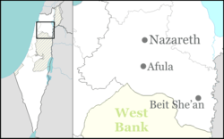
| District | Northern |
| Government | |
| • Type | Local council (from 1960) |
| Area | |
| • Total | 4,087 dunams (4.087 km2 or 1.578 sq mi) |
| Population (2015)[1] | |
| • Total | 18,234 |
| Name meaning | Jaffa of Nazareth |
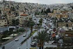
Yafa an-Naseriyye (Arabic: يافة الناصرة, "Jaffa of Nazareth", also Yafa, Kfar Yafia or Yafi Arabic: يافا, يفيع, Hebrew: יָפָא, יָפִיעַ) is an Arab town located in the Lower Galilee, Israel. It forms part of the metropolitan area of Nazareth, also an Arab locality. Declared a local council in 1960, Yafa had a population of 18,234 in 2015, approximately 70% of whom are Muslim and 30% Christian.
History
Yafa an-Naseriyye is an ancient town where rock-tombs and cisterns, cut into rock, have been found.[2]
It was a vassal of Megiddo in the fourteenth century BCE, according to the Amarna letters.[3]
Sherds have been found, dating from the Iron Age IIA-B (late tenth and ninth centuries BCE); Hellenistic (late second and early first centuries BCE.) and Roman era (first to fourth century).[3]
It has been identified with the ancient town of Japhia,[4] mentioned in the Book of Joshua as a border town belonging to Zebulun (Joshua 19:12). Local medieval tradition holds that Zebedee and his two sons, James and John lived in Yafa.[5] As the first to mention this tradition was Marinus Sanutus, it was most likely a Crusader era invention.[6] Josephus mentions the city Japha (Yafa) in his Life of Flavius Josephus (§ 37 and 45) and Wars of the Jews (Book 3, chapter 7, verse 31).[7]
Chambers, cut in stone, three storeys high, have been found in the village. This was probably an old granary.[8] Victor Guérin noted that when one of the chambers was cleared out in 1869, a vase was found containing about two hundred coins of Roman emperors. According to his observations, there were two of the subterranean systems, one of which is described above, both of which have suffered considerable damage since they were first visited by him in 1870. He found nothing of the ancient town, except five or six fragments of columns, broken stones, and about thirty cisterns. The city formerly included three adjacent hills.[9]
Remains of a building from the Mamluk era has been excavated, with pottery sherds from that period.[10]
Ottoman era
In 1517, the village was incorporated into the Ottoman Empire with the rest of Palestine, and in 1596 it appeared in the Ottoman tax registers as being in the nahiya ("Subdistrict") of Tabariyya under the Liwa ("District") of Safad with a population of 14 Muslim households. The villagers paid taxes on wheat, barley, fruit trees, occasional revenues, goats and beehives.[11][12]
A map from Napoleon's invasion of 1799 by Pierre Jacotin showed the place, named as Iaffa.[13] In 1838 Edward Robinson described it as a small village, with 30 houses and the remains of a church.[6]
When Guérin visited in 1875, he found 400 inhabitants including Latins, Greek Orthodox, and Moslems. There were also Protestant schools in the village.[14]
In 1881, the Palestine Exploration Fund's Survey of Western Palestine (SWP) described it as a "moderate-sized village in a strong position on the spur running from Nazareth down to Jebata. It has a well to the north side and a second in the valley to the north-east."[15]
British Mandate era
In the 1922 census of Palestine conducted by the British Mandate authorities, Yafa had a total population of 615; 215 Muslims and 400 Christians,[16] Of the Christians, 168 were Orthodox, 112 Catholics, 108 Greek Catholic (Melchite) and 12 Anglicans.[17] The population had increased at the 1931 census, when Yafa, (including Arab el Ghazzalin), had a population of 833; 456 Muslims and 377 Christians, in a total of 213 houses.[18]
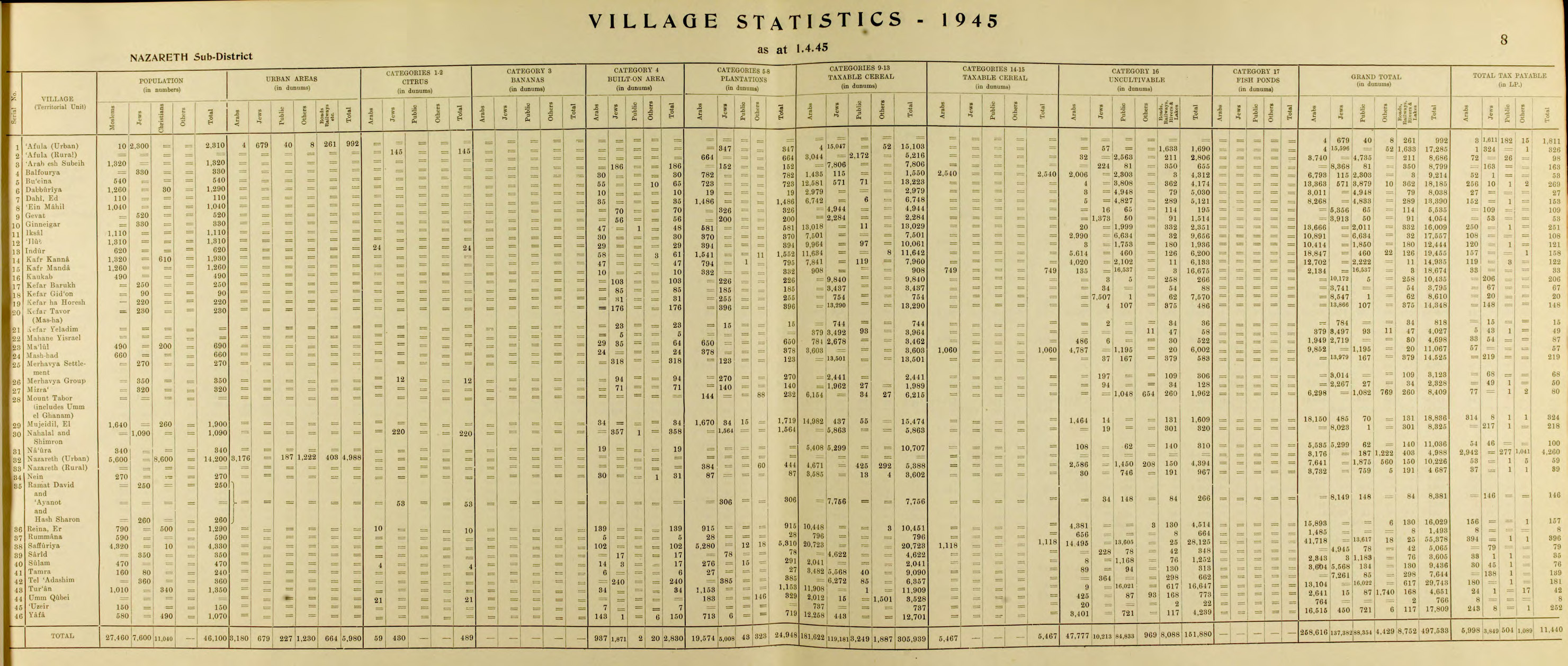
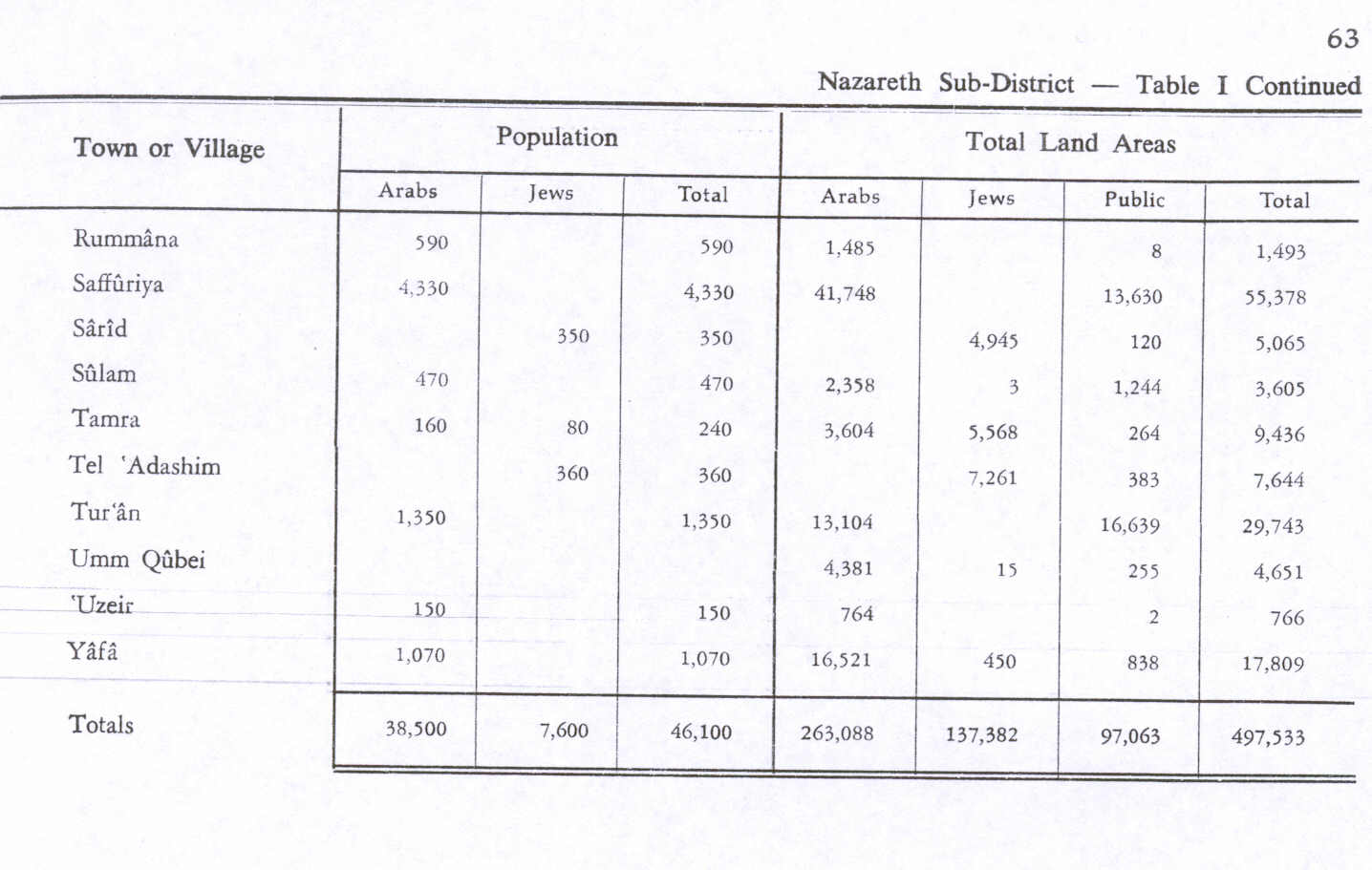
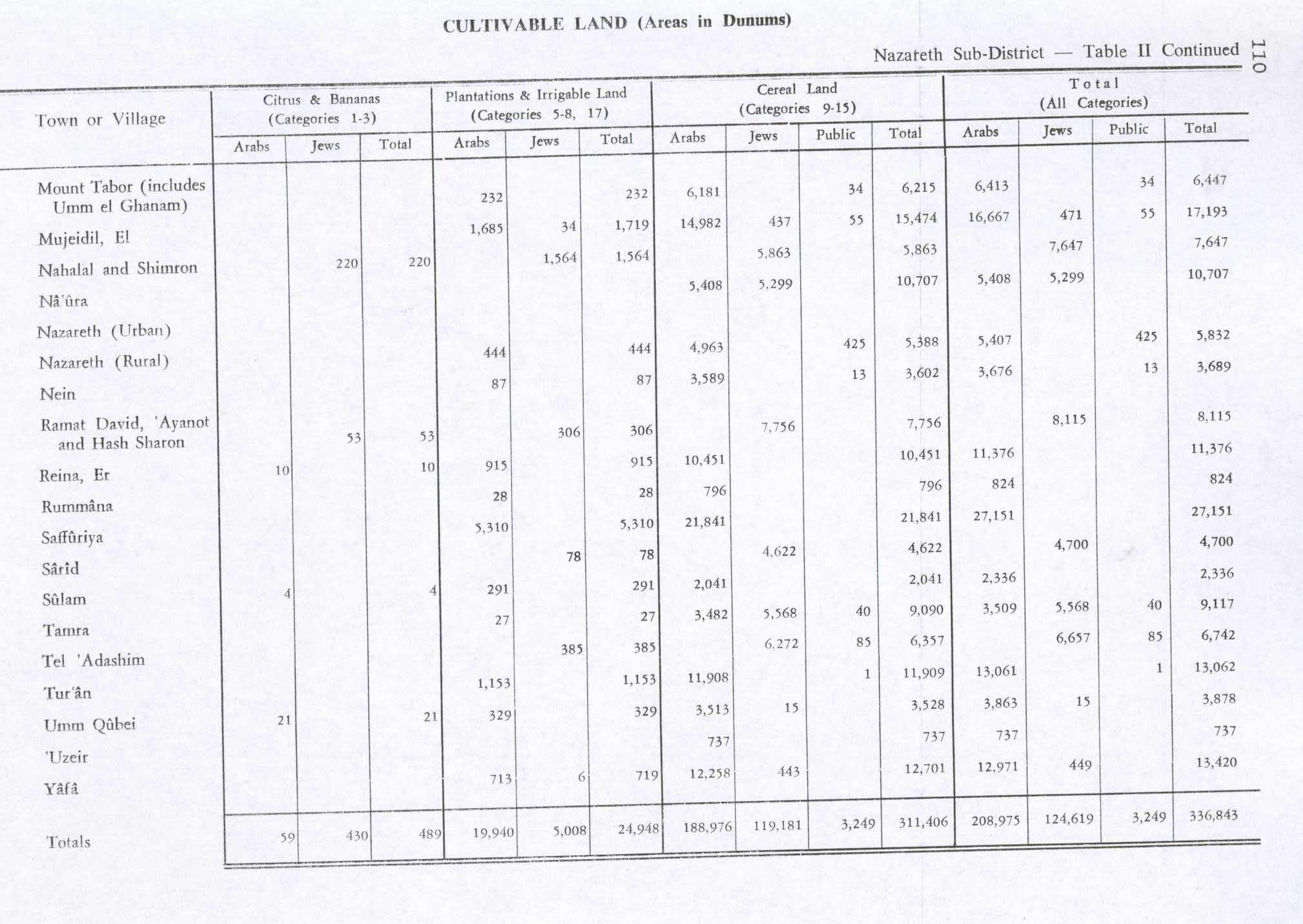
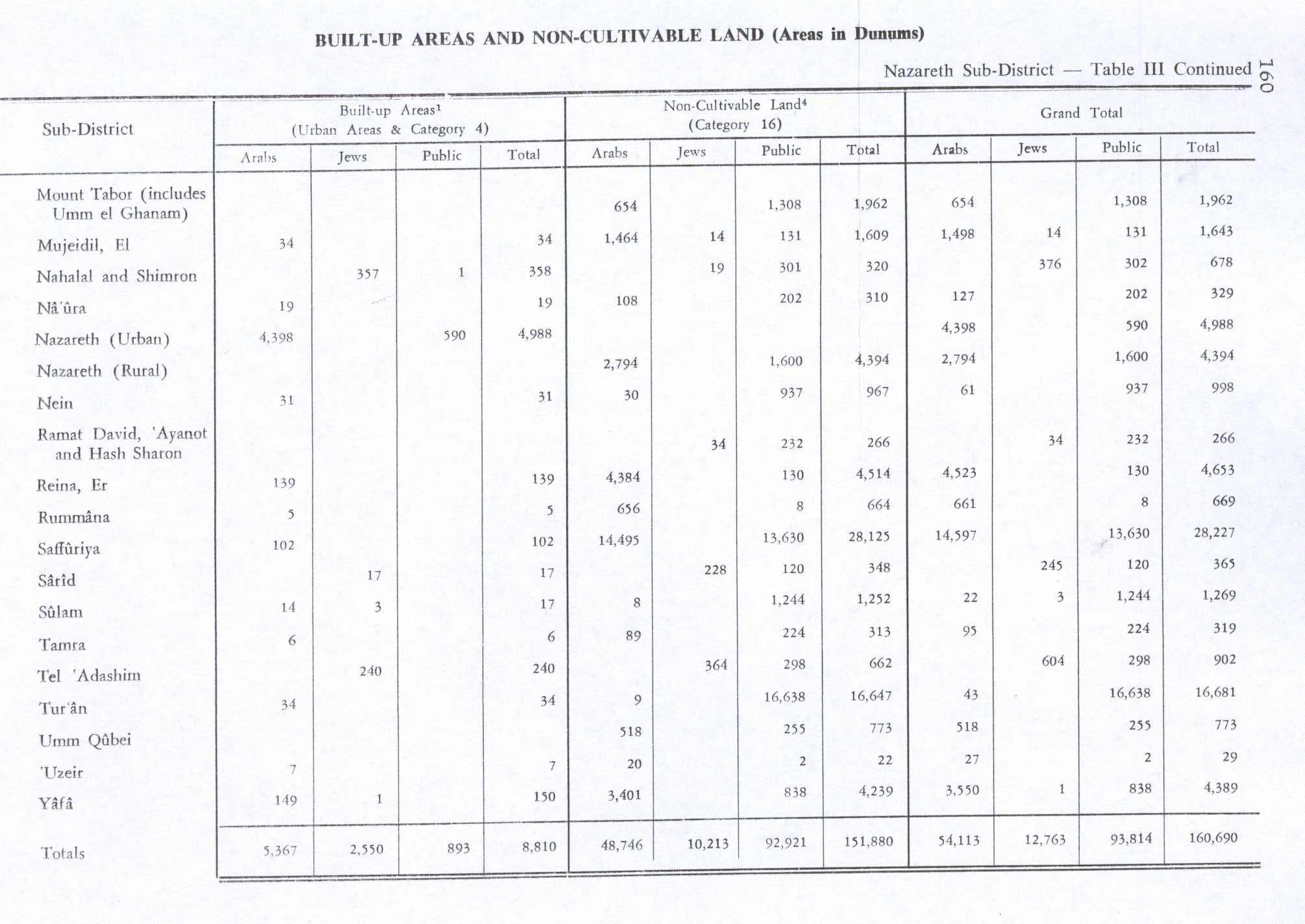
In 1945 the population size of Yafa was 1,070; 580 Muslims and 490 Christians,[19] with a total of 17,809 dunams of land, according to an official land and population survey.[20] Of this, 710 dunams were plantations and irrigable land, 12,701 used for cereals,[21] while 149 dunams were built-up land.[22]
State of Israel

In 1948 Yafa was captured by the Israeli army during Operation Dekel which was launched in July.[23] The remaining population were put under Martial Law which remained in fore until 1966. A substantial portion of Yafa's population today are the descendents of internally displaced Palestinians from the neighbouring village of Ma'alul which was depopulated during the 1948 Arab-Israeli war. People from Ma'alul participated in the local elections in Yafa under the banner of the "Ma'alul refugees' party" with platform also focused on issues of interest or concern to wider population as a way of attracting political support from local parties.[24]
Economy
In 2015, SanDisk Israel opened an R&D center in Kfar Yafia.[25]
Notable residents
See also
References
- ↑ "List of localities, in Alphabetical order" (PDF). Israel Central Bureau of Statistics. Retrieved 16 October 2016.
- ↑ Dauphin, 1998, p. 689
- 1 2 Alexandre, 2012, Yafi‘a Final report
- ↑ Palmer, 1881, p. 120
- ↑ Edgar Johnson Goodspeed (December 1900). "From Haifa to Nazareth". The Biblical World. 16 (6): 407–413. doi:10.1086/472713. JSTOR 3136947.
- 1 2 Robinson and Smith, 1841, vol 3, pp. 183, 200
- ↑ Whiston, William (1737): Josephus' The War of the Jews, translated by William Whiston
- ↑ Conder and Kitchener, 1881, SWP I, pp. 353-354
- ↑ Guérin, 1880, pp. 103-105, as given by Conder and Kitchener, 1881, SWP I, p. 354
- ↑ Zidan, 2015, Yafi‘a
- ↑ Hütteroth and Abdulfattah, 1977, p. 190
- ↑ Note that Rhode, 1979, p. 6 writes that the register that Hütteroth and Abdulfattah studied was not from 1595/6, but from 1548/9
- ↑ Karmon, 1960, p. 167.
- ↑ Guérin, 1880, p. 103, as given by Conder and Kitchener, 1881, SWP I, p. 280
- ↑ Conder and Kitchener, 1881, SWP I, p. 280
- ↑ Barron, 1923, Table XI, Sub-district of Nazareth, p. 38
- ↑ Barron, 1923, Table XVI, p. 50
- ↑ Mills, 1932, p. 76
- ↑ Department of Statistics, 1945, p. 8
- ↑ Government of Palestine, Department of Statistics. Village Statistics, April, 1945. Quoted in Hadawi, 1970, p. 63
- ↑ Government of Palestine, Department of Statistics. Village Statistics, April, 1945. Quoted in Hadawi, 1970, p. 110
- ↑ Government of Palestine, Department of Statistics. Village Statistics, April, 1945. Quoted in Hadawi, 1970, p. 160
- ↑ Morris, 1987, p. 200
- ↑ Nihad Bokae'e (February 2003). "Palestinian Internally Displaced Persons inside Israel:Challenging the Solid Structures" (PDF). Badil. Archived from the original (PDF) on June 14, 2007.
- ↑ anDisk opens R&D center in Israeli Arab town
Bibliography
| Wikimedia Commons has media related to Yafa an-Naseriyye. |
- Alexandre, Yardenna (2012-10-03). "Yafi'a Final report" (124). Hadashot Arkheologiyot – Excavations and Surveys in Israel.
- Barron, J. B., ed. (1923). Palestine: Report and General Abstracts of the Census of 1922. Government of Palestine.
- Conder, Claude Reignier; Kitchener, H. H. (1881). The Survey of Western Palestine: Memoirs of the Topography, Orography, Hydrography, and Archaeology. 1. London: Committee of the Palestine Exploration Fund.
- Department of Statistics (1945). Village Statistics, April, 1945. Government of Palestine.
- Dauphin, Claudine (1998). La Palestine byzantine, Peuplement et Populations. BAR International Series 726 (in French). III : Catalogue. Oxford: Archeopress. ISBN 0-860549-05-4.
- Guérin, Victor (1880). Description Géographique Historique et Archéologique de la Palestine (in French). 3: Galilee, pt. 1. Paris: L'Imprimerie Nationale.
- Hadawi, Sami (1970). Village Statistics of 1945: A Classification of Land and Area ownership in Palestine. Palestine Liberation Organization Research Center.
- Hütteroth, Wolf-Dieter; Abdulfattah, Kamal (1977). Historical Geography of Palestine, Transjordan and Southern Syria in the Late 16th Century. Erlanger Geographische Arbeiten, Sonderband 5. Erlangen, Germany: Vorstand der Fränkischen Geographischen Gesellschaft. ISBN 3-920405-41-2.
- Karmon, Y. (1960). "An Analysis of Jacotin's Map of Palestine" (PDF). Israel Exploration Journal. 10 (3,4): 155–173; 244–253.
- Mills, E., ed. (1932). Census of Palestine 1931. Population of Villages, Towns and Administrative Areas (PDF). Jerusalem: Government of Palestine.
- Morris, Benny (1987). The Birth of the Palestinian refugee problem, 1947-1949. Cambridge University Press. ISBN 0-521-33028-9.
- Palmer, E. H. (1881). The Survey of Western Palestine: Arabic and English Name Lists Collected During the Survey by Lieutenants Conder and Kitchener, R. E. Transliterated and Explained by E.H. Palmer. Committee of the Palestine Exploration Fund.
- Rhode, Harold (1979). Administration and Population of the Sancak of Safed in the Sixteenth Century. Columbia University.
- Robinson, Edward; Smith, Eli (1841). Biblical Researches in Palestine, Mount Sinai and Arabia Petraea: A Journal of Travels in the year 1838. 3. Boston: Crocker & Brewster.
- Zidan, Omar (2015-12-06). "Yafi'a Final report" (127). Hadashot Arkheologiyot – Excavations and Surveys in Israel.
External links
- Official website
- Welcome To Yaffa
- Survey of Western Palestine, Map 5: IAA, Wikimedia commons
- Yafi at Flags of the World