Wulai District
| Wulai 烏來區 | |
|---|---|
| Mountain Indigenous District | |
| Wulai District | |
 | |
 Wulai District in New Taipei City | |
| Country | Taiwan |
| Municipality | New Taipei City |
| Boroughs |
List
|
| Government | |
| • Type | District government |
| • District chief | Kao Fu-kuang (Ind.) |
| Population (January 2016) | |
| • Total | 6,182 |
Wulai District (Chinese: 烏來區; pinyin: Wūlái Qū; Pe̍h-ōe-jī: U-lai-khu)[1] is a mountain indigenous district in southern New Taipei City in northern Taiwan. It sits near the border with Taipei and is famous for its hot springs.[2] It is the largest district in New Taipei, as well as the most mountainous, and is home to the Atayal people of the Taiwanese aborigines.
Name
The name of the town derives from the Atayal phrase kilux ulay meaning "hot and poisonous" when an Atayal aborigine was hunting by a stream and saw mist coming from the stream.[3]
History
Formerly classified as "Savage Land" under Taihoku Prefecture during Japanese rule.
In August 2015, Wulai was devastated by Typhoon Soudelor, wiping out several hotels and destroying hot springs in the region. Course of the Nanshi River that passes through the district has changed and the riverbank was eroded heavily by surging water.[2] Heavy landslides were attributed to the overdevelopment of the mountain areas around the river which damaged the soil and watershed along the slope lands.[4]
Geography
- Elevation: 250 meters (820 ft) (average)
- Area: 321.13 square kilometers (123.99 sq mi)
- Population: 6,165 People (December 2014)
Administrative divisions
Zhongzhi Village, Wulai Village, Xiaoyi Village, Xinxian Village and Fushan Village.
Tourist attractions
Wulai is a tourist town most renowned for its hot springs, sightseeing, and aboriginal culture. Other activities include hiking, camping, swimming, fishing, and birdwatching. During the spring, visitors come see the cherry trees bloom. According to locals, bathing in the odorless hot springs can cure skin diseases (such as ringworm, eczema, and herpes).
- Wulai Atayal Museum
- Wulai Old Street
- Wulai Tram Museum
- Yun Hsien Resort
- Wulai hot springs – visitors often go to the numerous hot spring hotels, public baths, as well as the Wulai river.
- Waterfalls – Several waterfalls exist in the Wulai gorge, but the largest is Wulai Waterfall.
- Wulai Gondola – the gondola takes visitors to the top of Wulai Falls, where it accesses a hotel, conference center, and the Yunxian playground.
- Atayal aboriginal culture – many shops in Wulai specialize in aboriginal foods, arts, crafts, and clothing.
Transportation

Road
Wulai District is accessible by Xindian Bus from Xindian Station of Taipei Metro to Wulai Bus Terminus.[5]
The 9A branch line of the Provincial Highway 9 passes through the district.[6]
Rail
The district also has the Wulai Scenic Train, a converted mine train built during the Japanese era that takes visitors from downtown Wulai to the attractions at the base of Wulai Waterfall.
Notable people
- Tony Coolidge (1970-), Atayal-American filmmaker
Galleries
 Children playing in the Wulai River
 Wulai Falls as seen from above from the Gondola
 Wulai Gorge as seen from the Gondola
 Aboriginal Shops on the main street
See also
References
- ↑ "Entry #35055 (烏來)". 臺灣閩南語常用詞辭典 [Dictionary of Frequently-Used Taiwan Minnan] (in Chinese and Hokkien). Ministry of Education, R.O.C. 2011.
- 1 2 Shan, Shelley (11 Aug 2015). "Rescuers search for missing in Wulai". Taipei Times. p. 1.
- ↑ http://www.chinapost.com.tw/art/lifestyle/2015/02/21/429383/Visit-Wulai.htm
- ↑ http://www.chinapost.com.tw/taiwan/local/taipei/2015/08/11/442975/Wulai-cut.htm
- ↑ "Wulai travel guide of hot destinations(旅遊王TravelKing)–Taiwan travel hotels,New Taipei City tourism,Wulai". Travelking.com.tw. Retrieved 2014-05-23.
- ↑ "Premier orders swift repairs of roads and communication in Wulai(Executive Yuan, R.O.C. (Taiwan)-Press Releases)". ey.gov.tw.
External links
| Wikimedia Commons has media related to Wulai District. |
Districts of New Taipei | ||
|---|---|---|
City seat: Banqiao | ||
| Northern | 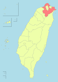 | |
| Eastern | ||
| Western | ||
| Southern | ||
| Mountain indigenous district | ||
Note: Although Hanyu Pinyin is the national standard, the municipal government endorses and uses "New Taipei" instead of "Xinbei" and "Tamsui" instead of "Danshui." | ||
Taiwanese aboriginal areas | ||||||||||||||||||||||||||||||||||||||||||||||||
|---|---|---|---|---|---|---|---|---|---|---|---|---|---|---|---|---|---|---|---|---|---|---|---|---|---|---|---|---|---|---|---|---|---|---|---|---|---|---|---|---|---|---|---|---|---|---|---|---|
| Highland aboriginal Townships and Districts |
|  | ||||||||||||||||||||||||||||||||||||||||||||||
| Plains aboriginal Townships and County-Controlled Cities |
| |||||||||||||||||||||||||||||||||||||||||||||||
Note: On the map, "Highland aboriginal areas" are in green, and "Plains aboriginal areas" are in tan. | ||||||||||||||||||||||||||||||||||||||||||||||||
Coordinates: 24°52′N 121°33′E / 24.867°N 121.550°E