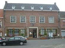
Wormhout
| Wormhout | |
|---|---|
 | |
 Wormhout | |
|
Location within Hauts-de-France region  Wormhout | |
| Coordinates: 50°53′00″N 2°28′07″E / 50.8833°N 2.4686°ECoordinates: 50°53′00″N 2°28′07″E / 50.8833°N 2.4686°E | |
| Country | France |
| Region | Hauts-de-France |
| Department | Nord |
| Arrondissement | Dunkirk |
| Canton | Wormhout |
| Intercommunality | Yser |
| Government | |
| • Mayor (2008–2014) | René Kerckhove |
| Area1 | 27.41 km2 (10.58 sq mi) |
| Population (1999)2 | 4,984 |
| • Density | 180/km2 (470/sq mi) |
| Time zone | CET (UTC+1) |
| • Summer (DST) | CEST (UTC+2) |
| INSEE/Postal code | 59663 / 59470 |
| Elevation |
5–33 m (16–108 ft) (avg. 19 m or 62 ft) |
|
1 French Land Register data, which excludes lakes, ponds, glaciers > 1 km² (0.386 sq mi or 247 acres) and river estuaries. 2 Population without double counting: residents of multiple communes (e.g., students and military personnel) only counted once. | |
Wormhout (older version: Wormhoudt) is a commune in the Nord department in northern France. A few people in Wormhout still speak Flemish, a local dialect of Dutch while French-speakers form a majority.
The town's name is of Germanic origin.[1]
Neighbouring towns and villages :
- Ledringhem to the south-west, separated by river Peene Becque
- Esquelbecq
Heraldry
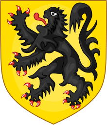 |
The arms of Wormhout are blazoned : Or, a lion sable armed and langued gules. ('Flanders' and the communes of Thourotte, Crépy-en-Valois, Bollezeele, Feignies, Flines-lez-Raches and Wormhout use the same arms.) |
Sights

- Old wind mill
- Jeanne Devos museum
Education
Wormhout has a number of school providing education structures for all of the pupils around the town : école du bocage, école Roger Salengro, école Saint-Joseph, collège du Houtland, école Jean Moulin, collège Notre-Dame, lycée de l'Yser.
Twinnage
Wormhout is twinned with the resort town of Llandudno, Conwy, Wales.
See also
References
- ↑ Wormhout Tourist Office. See "Origine et histoire" under "Renseignements".
| Wikimedia Commons has media related to Wormhout. |