Woodmead
| Woodmead | |
|---|---|
 Woodmead  Woodmead  Woodmead
| |
|
Location within Greater Johannesburg 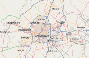 Woodmead | |
| Coordinates: 26°02′46″S 28°03′58″E / 26.046°S 28.066°ECoordinates: 26°02′46″S 28°03′58″E / 26.046°S 28.066°E | |
| Country | South Africa |
| Province | Gauteng |
| Municipality | City of Johannesburg |
| Main Place | Sandton |
| Area[1] | |
| • Total | 6.50 km2 (2.51 sq mi) |
| Population (2011)[1] | |
| • Total | 4,225 |
| • Density | 650/km2 (1,700/sq mi) |
| Racial makeup (2011)[1] | |
| • Black African | 28.3% |
| • Coloured | 1.7% |
| • Indian/Asian | 7.8% |
| • White | 60.5% |
| • Other | 1.7% |
| First languages (2011)[1] | |
| • English | 69.3% |
| • Afrikaans | 7.6% |
| • Zulu | 5.6% |
| • Northern Sotho | 2.7% |
| • Other | 14.7% |
| Postal code (street) | 2191 |
Woodmead is mostly a commercial suburb in the northern part of Johannesburg, Gauteng, South Africa. Four highways meet here, the N1 Western Bypass, N1 Ben Schoeman, N3 Eastern Bypass, and the M1. The southern terminus of the R55 road is also located here. Access is off the Woodmead offramp to the M1. Several large business are located in Woodmead, including 3M, Ericsson, Accenture, and SAP.
The 94.7 Cycle Challenge starts at the intersection of Woodmead Drive and Van Reenen in Woodmead. This is a 94.7 kilometre cycle race that is held every year and is sponsored by 94.7 Highveld Stereo, a popular regional radio station. Woodmead is also the site of a large 18-hole golf course, which opened in 1968.
References
- 1 2 3 4 "Sub Place Woodmead". Census 2011.
This article is issued from Wikipedia - version of the 7/30/2016. The text is available under the Creative Commons Attribution/Share Alike but additional terms may apply for the media files.