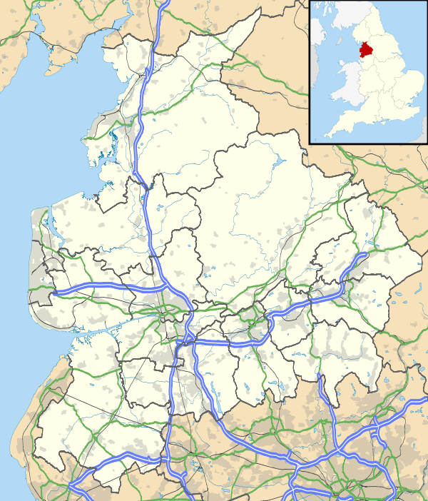
Wiswell
| Wiswell | |
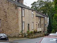 Wiswell village |
|
 Wiswell |
|
| Population | 967 (2011) |
|---|---|
| OS grid reference | SD745375 |
| Civil parish | Wiswell |
| District | Ribble Valley |
| Shire county | Lancashire |
| Region | North West |
| Country | England |
| Sovereign state | United Kingdom |
| Post town | CLITHEROE |
| Postcode district | BB7 |
| Dialling code | 01254 |
| Police | Lancashire |
| Fire | Lancashire |
| Ambulance | North West |
| EU Parliament | North West England |
| UK Parliament | Ribble Valley |
|
|
Coordinates: 53°49′59″N 2°23′17″W / 53.833°N 2.388°W
Wiswell is a small village and civil parish in the Ribble Valley, within the county of Lancashire, England. The population of the civil parish at the 2011 census was 967.[1] It is close to the village of Whalley and town of Clitheroe at the foot of Wiswell Moor.
According to the United Kingdom Census 2011, the parish has a population of 967,[2] a decrease from 985 in the 2001 census.[3]
The parish adjoins the other Ribble Valley parishes of Pendleton, Sabden, Whalley and Barrow. Higher areas of the parish, east of the village are part of the Forest of Bowland Area of Outstanding Natural Beauty (AONB).[4]
Toponomy
The name Wiswell is commonly spoken as wizel. The true pronunciation is more like 'wize-well' consistent with the original spellings of "Wyswell" or "Wiswall". There are several theories about the origins of the name. It is said to take its name from Old Molly's Well, a local landmark, later to become known as Wise Woman's Well (Wise Well). Alternatively, 'Wis' could have been part of the name of an Old English personal name.[5]
Governance
Wiswell was once a township in the ancient parish of Whalley. This became a civil parish in 1866, forming part of the Clitheroe Rural District from 1894 to 1974. Parts of the parish transferred to Sabden on its creation in 1904.[lower-alpha 1][7] It has since become part of the borough of Ribble Valley. In 2015 Barrow was split from Wiswell to form a separate parish council.[8]
Along with Barrow (since 2015), Pendleton, Mearley and Worston, the parish forms the Wiswell and Pendleton ward of Ribble Valley Borough Council. [9][10] The ward had a population of 1,289 in 2001,[11] rising to 1,316 in 2011.[12] The ward elects a single councillor, who currently is Robert Thompson of the Conservative Party.[13]
Amenities

Today the village only boasts a pub/restaurant (Freemasons Arms). However, there used to be a small corner shop, school and church; the names of each still stand on the original buildings but they are now prominent houses in the village.
The property in which the current pub operates was not originally designed as a public house. It was formerly three small cottages one of which was a freemasons' lodge, which is how it acquired its name. The original village pub, the Lamb Inn, was located adjacent to the public phone box, but no longer exists and is now known as Clegg House, a residence on the corner of Coronation Gardens. The Lamb Inn closed over 150 years ago and Wiswell was without a pub for some time as the Freemasons did not open until considerably later on.
Population
Towards the end of the 19th century about forty percent of the people who lived in Wiswell left to live elsewhere. This was probably related to job losses (through the temporary closure of the Barrow mill) and significant employment opportunities elsewhere. The British census figures taken every ten years from 1801 to 1871 show the population changes.
The census uses the highway from Whalley to Pendleton to divide Wiswell into 'West' and 'East':
- West
- Wiswell township (part of) in the parish of Whalley. All that part of the township of Wiswell which lies on the Western side of the highway leading from the town of Whalley to the village of Pendleton and which passes through the town of Wiswell [and includes Barrow].
- East
- All that part of the township of Wiswell which lies on the Eastern side of the Highway leading from Whalley to Pendleton including Briggs farm, Busskens Hill, Wiswell Hall, Wiswell Eaves and the remaining cottages on the Eastern side of the Highway.
In the censuses from 1801 to 1841, the population rose sharply and stabilised between 1841 and 1851 at about 750 people. Following this the population declined sharply to about 420 in 1871.
The change in population in the 1850s was dramatic. It seems likely that the Barrow Print Works closed for a time after 1851 or at least significantly reduced its workforce. Notes in the 1861 census highlight "a decrease in the population of the Townships of Wiswell and Whalley which is attributed to the discontinuance of employment in the Printworks."
See also
References
Notes
- ↑ The old township also shared a boundary with Read at Sabden Brook.[6]
Citations
- ↑ "Civil Parish 2011". Retrieved 23 January 2016.
- ↑ "Key Figures for 2011 Census: Key Statistics". Office for National Statistics. Retrieved 2 September 2015.
- ↑ Office for National Statistics : Census 2001 : Key Statistics Retrieved 2 September 2015
- ↑ Forest of Bowland map (Map). forestofbowland.com. Lancashire County Council.
- ↑ Ekwall, Eilert (1922). The place-names of Lancashire. Manchester University Press. p. 77.
- ↑ Lancashire and Furness (Map) (1st ed.). 1 : 10,560. County Series. Ordnance Survey. 1848.
- ↑ "Wiswell Tn/CP through time". visionofbritain.org.uk. GB Historical GIS / University of Portsmouth. Retrieved 31 August 2015.
- ↑ "Council divides". Lancashire Telegraph. 1 April 2015. p. 17.
- ↑ "Wiswell and Pendleton". MARIO. Lancashire County Council. Retrieved 26 March 2016.
- ↑ "Wiswell and Pendleton". Ordnance Survey Linked Data Platform. Ordnance Survey. Retrieved 26 March 2016.
- ↑ "Wiswell and Pendleton ward population 2001". Neighbourhood Statistics. Office for National Statistics. Retrieved 26 March 2016.
- ↑ "Wiswell and Pendleton ward population 2011". Neighbourhood Statistics. Office for National Statistics. Retrieved 26 March 2016.
- ↑ "Councillors by Ward: Wiswell and Pendleton". Ribble Valley Borough Council. Retrieved 26 March 2016.
External links
| Wikimedia Commons has media related to Wiswell. |