Whakaari / White Island
| Whakaari/White Island | |
|---|---|
| Whakaari (Māori) | |
 Whakaari/White Island, Bay of Plenty, New Zealand | |
| Highest point | |
| Elevation | 321 m (1,053 ft) |
| Prominence | 321 m (1,053 ft) |
| Coordinates | 37°31′S 177°11′E / 37.517°S 177.183°ECoordinates: 37°31′S 177°11′E / 37.517°S 177.183°E |
| Geography | |
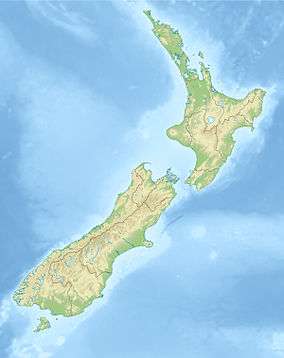 Whakaari/White Island Location of Whakaari/White Island | |
| Location | Bay of Plenty, North Island, New Zealand |
| Geology | |
| Mountain type | Stratovolcano |
| Volcanic arc/belt | Taupo Volcanic Zone |
| Last eruption | 27 April 2016 - 9.30 pm |
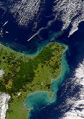
Whakaari / White Island is an active andesite stratovolcano, situated 48 km (30 mi) from the east coast of the North Island of New Zealand, in the Bay of Plenty. It is New Zealand's most active cone volcano, and has been built up by continuous volcanic activity over the past 150,000 years.[1] The nearest mainland towns are Whakatane and Tauranga. White Island has been in a nearly continuous stage of smoking since it was discovered by James Cook in 1769.
The island is roughly circular, about 2 km (1.2 mi) in diameter, and rises to a height of 321 m (1,053 ft) above sea level. However this is only the peak of a much larger submarine mountain, which rises up to 1,600 m (5,249 ft) above the nearby seafloor. Sulfur mining was attempted but was abandoned in 1914 after a lahar killed all 10 workers. The main activities on the island now are guided tours and scientific research.

Volcanology
Whakaari's eruptions have produced both lava flows and explosive eruptions of ash. It is New Zealand's most well-known active marine volcano, attracting scientists and volcanologists worldwide as well as many tourists. It is part of the Taupo Volcanic Zone.
Volcanologists from the GeoNet Project continually monitor the volcano's activity via surveillance cameras. Survey pegs, magnetometers and seismograph equipment for early earthquake warnings via radio have also been installed on the crater walls. The island is usually on an alert level rating of 1 or 2 on a scale of 0 to 5. This volcano is monitored by the Deep Earth Carbon Degassing Project. At most times the volcanic activity is limited to steaming fumaroles and boiling mud. In March 2000, three small vents appeared in the main crater and began belching ash which covered the island in fine grey powder. An eruption on 27 July 2000 blanketed the island with mud and scoria and a new crater appeared. Major eruptions in 1981–83 altered much of the island's landscape and decimated the extensive pōhutukawa forest. The large crater created at that time now contains a lake, whose level varies substantially. Between July and August 2012 White Island showed signs of increased activity with lake and gas levels rising from inside the crater. On 5 August 2012 a minor eruption occurred,[2] sending ash into the air. More eruptions have followed since.[3]
Continued volcanic activity and tremors on 25 January 2013 suggested another eruption was imminent.[4] A small eruption occurred on 20 August 2013 at 10.23am, lasting for 10 minutes and producing mostly steam. According to The New Zealand Herald newspaper, "Civil Defence will monitor White Island (Whakari) following a small eruption which could be part of a sequence leading to a bigger event."[5]
History

The full Māori name for the island is 'Te Puia o Whakaari', meaning 'The Dramatic Volcano.' It was named 'White Island' by Captain Cook on 1 October 1769 because it always appeared to be in a cloud of white steam. Although Cook went close to the island he failed to notice that it was a volcano. Its official name is Whakaari/White Island although it is best known as White Island.
Attempts were made in the mid-1880s, 1898–1901 and 1913–1914 to mine sulphur from White Island, with the island at first being owned by John Wilson.[6] The mining came to a halt in September 1914, when part of the western crater rim collapsed, creating a lahar which killed all 10 workers.[7] They disappeared without trace, and only a camp cat survived. He was found some days afterwards by the resupply ship, and dubbed "Peter the Great".[8][9] Some years later in 1923, mining was again attempted, but learning from the 1914 disaster, the miners built their huts on a flat part of the island near a gannet colony. Each day they would lower their boat into the sea from a gantry, and row around to the mining factory wharf in Crater Bay. If the sea was rough they had to clamber around the rocks on a very narrow track on the crater's edge. Before the days of antibiotics, sulphur was used in medicines as an antibacterial agent, in the making of match heads, and for sterilising wine corks. The miner's diggings were handled in small rail trucks to the crushing and bagging process in the factory built on the island. Unfortunately, there was not enough sulphur at Whakaari and so the ground-up rock was used as a component of agricultural fertiliser. Eventually the mining ended in the 1930s because of the poor mineral content in the fertiliser. The remains of the buildings can still be seen, much corroded by the sulphuric gases.
Important bird area
The island has been identified as an Important Bird Area by BirdLife International because of its breeding colony of about 3000 pairs of Australasian gannets.[10]
Access

White Island is privately owned. It was declared a private scenic reserve,[11] in 1953,[12][13] and is subject to the provision of the Reserves Act 1977.[14] Visitors cannot land without permission. However, it is easily accessible by authorised tourist operators.[11]
The waters surrounding White Island are well known for their fishing. Yellowtail kingfish abound all year round, and there is deep water fishing for hapuka and bluenose (a type of warehou) in the winter and blue, black and striped marlin and yellowfin tuna in the summer. A small charter fleet offering day trips and overnight or longer trips operates from the nearby port at Whakatane.
Dino

In May 2004 a Dino figurine was glued to a rock in front of the Geonet volcano camera on the island. Geonet decided not to have it removed, assuming it was a plastic toy and would not survive long in the corrosive environment.[15] As of 24 September 2014, the figurine was still present and did not appear visibly degraded.[16]
According to Craig Miller, the GeoNet Volcano Network Coordinator, the environment around the volcano has been relatively benign, even to the point that vegetation has been regrowing since the last eruptions in 2000, which may explain why the toy is still in good condition.[17] Another possible scenario is that the figurine is made out of porcelain[18] and as such would not be affected by any corrosive gases.
Sometime between 23 July and 24 July 2009, the Dino figure was moved to another location on camera.
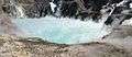 The crater lake in 2004
 Aerial view of the crater lake in 2005
 Short video of sulphurous fumarole
See also
Notes
- ↑ "White Island". GeoNet. Retrieved 30 December 2012.
- ↑ "Visitors warned off erupting volcano". stuff.co.nz. Retrieved 10 August 2012.
- ↑ "Ash from White Island volcano sprinkles Papamoa". nzherald.co.nz. 9 August 2012. Retrieved 10 August 2012.
- ↑ "White Island eruption increasingly likely". 3 News NZ. 25 January 2013.
- ↑ "Civil Defence monitor White Island volcano". The New Zealand Herald. 20 August 2013.
- ↑ Rorke, Jinty. "John Alexander Wilson". Dictionary of New Zealand Biography. Ministry for Culture and Heritage. Retrieved December 2011. Check date values in:
|access-date=(help) - ↑ Boon, Kevin. "The 1914 White Island eruption". URL accessed 4 December 2007. (Archived by WebCite at http://www.webcitation.org/5TqkjKdYS)
- ↑ Sarah Lowe and Kim Westerskov (1993). "Steam and brimstone", New Zealand Geographic 17, 82-106.
- ↑ Norton, Amelia. "White Island: Where Nature Reigns Supreme". Four Corners. Retrieved 17 November 2009.
- ↑ BirdLife International. (2012). Important Bird Areas factsheet: White Island (Whakaari). Downloaded from http://www.birdlife.org on 2 February 2012.
- 1 2 "Off the Beaten Track to... White Island". New Zealand Tourism Guide.
- ↑ "New Zealand: land of plenty". [Australian Geographic]]. 7 February 2013.
- ↑ "Annual Meeting Of The Council, 15Th May, 1954 Minutes" (PDF). Royal Society of New Zealand. 15 May 1954.
- ↑ Bruce D. Clarkson & Beverley R. Clarkson (1994). "Vegetation decline following recent eruptions on White Island (Whakaari), Bay of Plenty, New Zealand". New Zealand Journal of Botany. 32: 21.
- ↑ ABC News Online. Volcanologists spy pink 'dinosaur' on remote webcam. Accessed 4 December 2007. (Archived by WebCite at http://www.webcitation.org/5TqlCycX5)
- ↑ White Island volcano camera, Geonet. Accessed 16 October 2008.
- ↑ The Press. White Island dino survives. Accessed 31 August 2009
- ↑ http://www.goantiques.com Beswick Figure 'DINO'. Accessed 24 August 2008.
References
- "White Island". Global Volcanism Program. Smithsonian Institution. Retrieved 2009-01-01.
- Volcanic Hazards at White Island
- Volcano World: White Island
External links
| Wikivoyage has a travel guide for White Island. |
| Wikimedia Commons has media related to Whakaari/White Island. |