West Mata
| West Mata | |
|---|---|
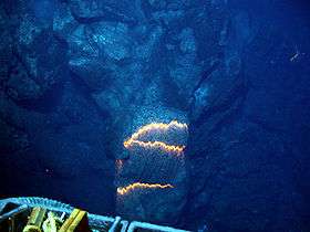 Bands of glowing magma from West Mata (May 2009) | |
| Highest point | |
| Elevation | -1,100 metres (-4,000 ft)[1] |
| Coordinates | 15°06′04″S 173°45′32″W / 15.101°S 173.759°WCoordinates: 15°06′04″S 173°45′32″W / 15.101°S 173.759°W |
| Geography | |
| Location | 200km SW of Samoas |
| Geology | |
| Mountain type | Submarine volcano |
| Last eruption | 2008 to 2009 |
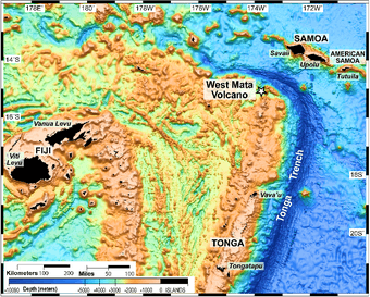
West Mata is a submarine volcano at 1,100 meters depth located 200 kilometres (120 mi) southwest of the Samoas. Its eruptions are currently the deepest observed.[2][3]
Geology
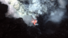
West Mata is located just west of the north end of the Tonga Ridge where the Tonga Trench makes a sharp turn to the west. It is in the NE Lau Basin about 35 km east of the Lau spreading center and about 70 km northeast of the currently erupting NE Lau spreading center.[4] The Research Vessel Thompson surveyed the area during November 2008 and May 2009. In November 2008, the researchers detected a plume of material over West Mata which indicated likely erupting lava flows and/or pyroclastic materials. The sulfur and iron rich plume contained mineral and/or glass shards. The shard compositions indicated that the erupted material was boninite (an olivine-bronzite andesite with little or no feldspar) which had never been observed from an active volcano.[4]
On 6–7 May 2009, the Jason 2 ROV (remotely operated vehicle) was used to observe eruptions from two vents of the linear West Mata peak, Prometheus (at or near the summit) and Hades (slightly to the SW). The Hades vent was erupting both effusively and explosively at the same time on both days (6–7 May). Small bursts were occurring at one end of an erupting fissure ~ 5 m long at a depth of 1,208 m, while pillow lavas were being extruded from the other end. By the next night (7 May) the activity had become more vigorous, sometimes blowing glowing bubbles as much as a meter across from the fissure.[4]
Filming
On December 17, 2009, NOAA released motion video and still imagery of the submarine volcano erupting. The footage was taken in May 2009 by the American Jason remotely operated underwater vehicle (ROV).
References
- ↑ "Deepest volcano caught on Pacific Ocean video". British Broadcasting Corporation. 2009-12-18. Retrieved 2009-12-19.
- ↑ "Scientists Discover and Image Explosive Deep-Ocean Volcano". NOAA. 2009-12-17. Retrieved 2009-12-19.
- ↑ Han, Phil (2009-12-18). "Scientists capture deepest underwater volcanic eruption on film". CNN. Retrieved 2009-12-19.
- 1 2 3 http://www.volcano.si.edu/world/volcano.cfm?vnum=0403-13-&volpage=var Smithsonian Institution, Global Volcanism Program, West Mata, Monthly Report, 06/2009