West Boylston, Massachusetts
| West Boylston, Massachusetts | ||
|---|---|---|
| Town | ||
|
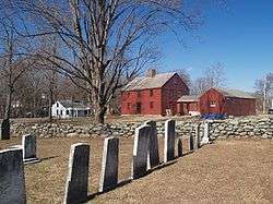
Bigelow Tavern (Historical Society) | ||
| ||
| Motto: "Small Town, Big Heart"[1] | ||
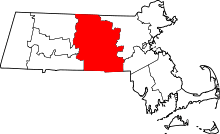
 Location in Worcester County and the state of Massachusetts. | ||
| Coordinates: 42°22′00″N 71°47′10″W / 42.36667°N 71.78611°WCoordinates: 42°22′00″N 71°47′10″W / 42.36667°N 71.78611°W | ||
| Country | United States | |
| State | Massachusetts | |
| County | Worcester | |
| Settled | 1642 | |
| Incorporated | 1808 | |
| Government | ||
| • Type | Open town meeting | |
| • Town Administrator | Leon Gaumond, Jr. | |
| • Board of Selectmen |
Kevin McCormick Christopher Rucho Allen Phillips Alexander Fallavollita John B. DiPietro, Sr. | |
| Area | ||
| • Total | 13.8 sq mi (35.8 km2) | |
| • Land | 12.9 sq mi (33.4 km2) | |
| • Water | 1.0 sq mi (2.5 km2) | |
| Elevation | 481 ft (147 m) | |
| Population (2010) | ||
| • Total | 7,669 | |
| • Density | 560/sq mi (210/km2) | |
| Time zone | Eastern (UTC-5) | |
| • Summer (DST) | Eastern (UTC-4) | |
| ZIP code | 01583 | |
| Area code(s) | 508 / 774 | |
| FIPS code | 25-75155 | |
| GNIS feature ID | 0618391 | |
| Website | http://www.westboylston.com/Pages/index | |
West Boylston is a town in Worcester County, Massachusetts, United States. The population was 7,669 at the 2010 census. West Boylston includes the village of Oakdale, located on the opposite side of the Wachusett Reservoir from West Boylston center along Route 140.
History
West Boylston was originally part of several neighboring towns – Lancaster, Shrewsbury, Boylston, Holden and Sterling. The town was created as part of a dispute between Boylston and West Boylston over the location of a new town meeting house. It was incorporated in 1808.
During the 1800s the town grew with textile and other industries and became a prosperous community. This prosperity was interrupted as the town was selected as the site of the Wachusett Reservoir to provide water for Boston. It was selected due to its location at the junction of three rivers: the Quinapoxet River, the Stillwater River and the Nashua River. In 1897, the Nashua River in the town of Clinton was impounded by the Wachusett Dam. 6.5 square miles (17 km2) were flooded in the towns of Boylston, West Boylston, Clinton and Sterling. Over 2,200 acres (8.9 km2) of West Boylston's land was used for the reservoir, the most of any town. This disrupted the center of town and most of the industrial base. Many buildings were moved to the unaffected parts of the town but the majority were demolished and filled by the reservoir. Over 1700 residents, 300 homes, eight schools, six mills, four churches and one hotel were moved to dry land. The state paid approximately 60 cents on the dollar for use of the land with the promise to pay $12,000 a year to the town for lost tax revenue forever. The reservoir was completed in 1905 and first filled in May 1908. West Boylston's prominent landmark, the Old Stone Church, was left remaining was a reminder of those that lost their homes and jobs to the building of the reservoir. It is one of the most photographed sites in the area.
Today, West Boylston has transformed itself into a bedroom community for Worcester and the surrounding region. Due to the reservoir, the town has been able to preserve much of its rural character, making it an attractive place for recreation and living.
West Boylston's most famous historical resident is Robert Bailey Thomas, the founder of the Old Farmer's Almanac.
Geography
According to the United States Census Bureau, the town has a total area of 13.8 square miles (36 km2), of which 12.9 square miles (33 km2) is land and 0.9 square miles (2.3 km2), or 6.86%, is water.
Adjacent cities and towns
 |
Sterling | | ||
| Holden | |
Boylston | ||
| ||||
| | ||||
| Worcester | Shrewsbury |
Demographics
| Historical population | ||
|---|---|---|
| Year | Pop. | ±% |
| 1850 | 1,749 | — |
| 1860 | 2,509 | +43.5% |
| 1870 | 2,862 | +14.1% |
| 1880 | 2,994 | +4.6% |
| 1890 | 3,019 | +0.8% |
| 1900 | 2,314 | −23.4% |
| 1910 | 1,270 | −45.1% |
| 1920 | 1,624 | +27.9% |
| 1930 | 2,114 | +30.2% |
| 1940 | 1,822 | −13.8% |
| 1950 | 2,570 | +41.1% |
| 1960 | 5,526 | +115.0% |
| 1970 | 6,369 | +15.3% |
| 1980 | 6,204 | −2.6% |
| 1990 | 6,611 | +6.6% |
| 2000 | 7,481 | +13.2% |
| 2010 | 7,669 | +2.5% |
| * = population estimate. Source: United States Census records and Population Estimates Program data.[2][3][4][5][6][7][8][9][10][11] | ||
As of the census[12] of 2000, there were 7,481 people, 2,413 households, and 1,747 families residing in the town. The population density was 580.0 inhabitants per square mile (223.9/km2). There were 2,458 housing units at an average density of 190.6 per square mile (73.6/km2). The racial makeup of the town was 91.63% White, 5.33% African American, 0.16% Native American, 0.86% Asian, 0.01% Pacific Islander, 0.63% from other races, and 1.38% from two or more races. Hispanic or Latino of any race were 4.77% of the population.
There were 2,413 households out of which 32.9% had children under the age of 18 living with them, 60.5% were married couples living together, 8.9% had a female householder with no husband present, and 27.6% were non-families. 23.8% of all households were made up of individuals and 11.1% had someone living alone who was 65 years of age or older. The average household size was 2.56 and the average family size was 3.04.
In the town the population was spread out with 21.4% under the age of 18, 8.5% from 18 to 24, 32.7% from 25 to 44, 22.7% from 45 to 64, and 14.7% who were 65 years of age or older. The median age was 38 years. For every 100 females there were 130.3 males. For every 100 females age 18 and over, there were 139.0 males. [The population of West Boylston (7481 in 2000) includes the approximately 1400 male residents of the Worcester County House of Correction; about 20% of the town's recorded population. So it would seem that West Boylston has about 30% more men than women (139 men for every 100 women) but that statistic is misleading.]
The median income for a household in the town was $53,777, and the median income for a family was $69,100. Males had a median income of $49,963 versus $32,557 for females. The per capita income for the town was $22,899. About 2.3% of families and 3.2% of the population were below the poverty line, including 3.2% of those under age 18 and 6.8% of those age 65 or over.
Arts and culture
Museums and other points of interest
West Boylston includes four entries on the National Register of Historic Places:
- Bigelow Tavern Historic District – 60, 64 and 65 Worcester St. (added October 24, 1992)
- Oakdale Village Historic District – 11–68 N. Main, May 8–24, 6–10 Green, 12–23 High, 4–68 Laurel, 14–34 Waushacum, and park at Thomas and N. Main (added August 5, 1996)
- Old Stone Church – Off MA 140 (added May 13, 1973)
- Quinapoxet River Bridge – Thomas St. over the Quinapoxet River at the Wachusett Reservoir (added May 8, 1990)
Government
| County-level state agency heads | |
|---|---|
| Clerk of Courts: | Dennis P. McManus (D) |
| District Attorney: | Joseph D. Early, Jr. (D) |
| Register of Deeds: | Anthony J. Vigliotti (D) |
| Register of Probate: | Stephanie K. Fattman (R) |
| County Sheriff: | Lew Evangelidis (R) |
| State government | |
| State Representative(s): | James O'Day (D) |
| State Senator(s): | Harriette L. Chandler (D) |
| Governor's Councilor(s): | Jen Caissie (R) |
| Federal government | |
| U.S. Representative(s): | James P. McGovern (D-2nd District), |
| U.S. Senators: | Elizabeth Warren (D), Ed Markey (D) |
Education
West Boylston Middle/High School and Major Edwards Elementary School are located in the town.
Library
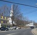
West Boylston's public library, the Beaman Memorial Public Library, was established in 1878.[13][14] In fiscal year 2008, the town of West Boylston spent 1.6% ($308,576) of its budget on its public library—some $37 per person.[15] The library building was listed on the National Register of Historic Places in 2016.
Media
The Banner newspaper covers current news about West Boylston; Coulter Press of Clinton, Massachusetts, publishes it.[16][17] In the past, other newspapers have included the News Recorder and West Boylston Times.[18]
Notable people
- Jim Ford - film and television actor / stuntman
- J. P. Ricciardi- former General Manager of the Major League Baseball Toronto Blue Jays
- James O'Day- State legislator
Photos
-
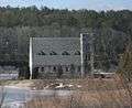
Oakdale, Massachusetts
-
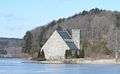
The Old Stone Church on the Wachusett Reservoir
-
-

Watering trough in front of the Beaman Memorial Public Library
References
- ↑ "West Boylston, MA". West Boylston, MA. Retrieved October 4, 2012.
- ↑ "TOTAL POPULATION (P1), 2010 Census Summary File 1". American FactFinder, All County Subdivisions within Massachusetts. United States Census Bureau. 2010.
- ↑ "Massachusetts by Place and County Subdivision - GCT-T1. Population Estimates". United States Census Bureau. Retrieved July 12, 2011.
- ↑ "1990 Census of Population, General Population Characteristics: Massachusetts" (PDF). US Census Bureau. December 1990. Table 76: General Characteristics of Persons, Households, and Families: 1990. 1990 CP-1-23. Retrieved July 12, 2011.
- ↑ "1980 Census of the Population, Number of Inhabitants: Massachusetts" (PDF). US Census Bureau. December 1981. Table 4. Populations of County Subdivisions: 1960 to 1980. PC80-1-A23. Retrieved July 12, 2011.
- ↑ "1950 Census of Population" (PDF). Bureau of the Census. 1952. Section 6, Pages 21-10 and 21-11, Massachusetts Table 6. Population of Counties by Minor Civil Divisions: 1930 to 1950. Retrieved July 12, 2011.
- ↑ "1920 Census of Population" (PDF). Bureau of the Census. Number of Inhabitants, by Counties and Minor Civil Divisions. Pages 21-5 through 21-7. Massachusetts Table 2. Population of Counties by Minor Civil Divisions: 1920, 1910, and 1920. Retrieved July 12, 2011.
- ↑ "1890 Census of the Population" (PDF). Department of the Interior, Census Office. Pages 179 through 182. Massachusetts Table 5. Population of States and Territories by Minor Civil Divisions: 1880 and 1890. Retrieved July 12, 2011.
- ↑ "1870 Census of the Population" (PDF). Department of the Interior, Census Office. 1872. Pages 217 through 220. Table IX. Population of Minor Civil Divisions, &c. Massachusetts. Retrieved July 12, 2011.
- ↑ "1860 Census" (PDF). Department of the Interior, Census Office. 1864. Pages 220 through 226. State of Massachusetts Table No. 3. Populations of Cities, Towns, &c. Retrieved July 12, 2011.
- ↑ "1850 Census" (PDF). Department of the Interior, Census Office. 1854. Pages 338 through 393. Populations of Cities, Towns, &c. Retrieved July 12, 2011.
- ↑ "American FactFinder". United States Census Bureau. Retrieved 2008-01-31.
- ↑ C.B. Tillinghast. The free public libraries of Massachusetts. 1st Report of the Free Public Library Commission of Massachusetts. Boston: Wright & Potter, 1891.
- ↑ Beaman Memorial Public Library. Retrieved November 10, 2010
- ↑ July 1, 2007 through June 30, 2008; cf. The FY2008 Municipal Pie: What’s Your Share? Commonwealth of Massachusetts, Board of Library Commissioners. Boston: 2009. Available: Municipal Pie Reports. Retrieved August 4, 2010
- ↑ "About Coulter Press". Worcester Telegram & Gazette Corp. Retrieved July 1, 2012.
- ↑ "Library Reference Resources: Newspapers". Beaman Memorial Public Library. Retrieved July 1, 2012.
- ↑ Boston Public Library, Microtext Department. "Massachusetts Newspapers". Newspapers on Microfilm. Retrieved 13 May 2012.
External links
| Wikimedia Commons has media related to West Boylston, Massachusetts. |
- West Boylston official website
- West Boylston Bicentennial 2008
- West Boylston Sports
- West Boylston Historical Society
- West Boylston Water District
- Beaman Memorial Public Library
- ePodunk: Profile for West Boylston, Massachusetts, MA