West Bagborough
| West Bagborough | |
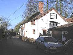 The Rising Sun, West Bagborough |
|
 West Bagborough |
|
| Population | 358 (2011)[1] |
|---|---|
| OS grid reference | ST171333 |
| District | Taunton Deane |
| Shire county | Somerset |
| Region | South West |
| Country | England |
| Sovereign state | United Kingdom |
| Post town | Taunton |
| Postcode district | TA4 |
| Police | Avon and Somerset |
| Fire | Devon and Somerset |
| Ambulance | South Western |
| EU Parliament | South West England |
| UK Parliament | Taunton Deane |
Coordinates: 51°05′37″N 3°11′06″W / 51.0935°N 3.1849°W
West Bagborough is a village and civil parish in Somerset, England, situated 5 miles (8.0 km) north of Taunton in the Taunton Deane district. The village has a population of 358.[1]
The village lies on the south-west slopes of the Quantock Hills and combines with the neighbouring hamlets of Shopnoller, Seven Ash and Westwood to form the parish of West Bagborough. The village has a wide variety of properties, with a wide range of building techniques and ages. Due to its availability, local red sandstone features heavily in buildings, both ancient and modern. The village has a 16th-century inn (the Rising Sun), a village hall, and a number of establishments offering accommodation.[2]
History
The origin of the village name is open to some debate and is thought to either come from the name "Begas Barrow" (meaning badger's hill)[3] or from an amalgamation of the family name "Baga" and the Old English word for hill, "beorg". In either case, by 1086, when the Domesday Book was compiled, the name had become Bageberge.
Around Wills Neck and the Triscombe Stone are several bowl barrows and cairns dating from the Bronze Age.[4][5][6][7][8][9]
The parish of West Bagborough was part of the Taunton Deane Hundred.[10]
Enclosure of lands within the parish was authorised by an Act of Parliament in 1806.
In October 2001 a hoard of 4th-century Roman silver was discovered in the village. The 681 coins included two denarii from the early 2nd century and eight miliarense and 671 siliqua all dating from the period AD 337 – 367. The majority were struck in the reigns of emperors Constantius II and Julian and derive from a range of mints including Arles and Lyons in France, Trier in Germany and Rome.[11] It became known as the West Bagborough Hoard.
Governance
The parish council has responsibility for local issues, including setting an annual precept (local rate) to cover the council’s operating costs and producing annual accounts for public scrutiny. The parish council evaluates local planning applications and works with the local police, district council officers, and neighbourhood watch groups on matters of crime, security, and traffic. The parish council's role also includes initiating projects for the maintenance and repair of parish facilities, as well as consulting with the district council on the maintenance, repair, and improvement of highways, drainage, footpaths, public transport, and street cleaning. Conservation matters (including trees and listed buildings) and environmental issues are also the responsibility of the council.
The village falls within the Non-metropolitan district of Taunton Deane, which was formed on 1 April 1974 under the Local Government Act 1972, having previously been part of Taunton Rural District.[12] The district council is responsible for local planning and building control, local roads, council housing, environmental health, markets and fairs, refuse collection and recycling, cemeteries and crematoria, leisure services, parks, and tourism.
Somerset County Council is responsible for running the largest and most expensive local services such as education, social services, libraries, main roads, public transport, policing and fire services, trading standards, waste disposal and strategic planning.
It is also part of the Taunton Deane county constituency represented in the House of Commons of the Parliament of the United Kingdom. It elects one Member of Parliament (MP) by the first past the post system of election, and part of the South West England constituency of the European Parliament which elects seven MEPs using the d'Hondt method of party-list proportional representation.
Church
The village church, St Pancras, dates from the 15th century, with the north aisle being added in 1839, and further restoration in 1872. It has been designated by English Heritage as a Grade II* listed building.[13] Further work was undertaken in the 1920s under the guidance of Sir Ninian Comper.[14] The church stands high above the main village, and allegedly owes this separation to the Black Death, which reduced the population to below one hundred souls in the fourteenth century. In an attempt to rid themselves of this plague the villagers abandoned the original settlement and re-built, away from the church. The lychgate is dedicated to the memory of Robert Brooke-Popham.[15]
The old rectory is now known as Little Court.[16]
Bagborough House
Bagborough House was built in 1739 by the Popham family, enlarged in 1820 and 1900, and is now lived in by Diana and Philip Brooke-Popham.[17][18]
References
- 1 2 "Statistics for Wards, LSOAs and Parishes — SUMMARY Profiles" (Excel). Somerset Intelligence. Retrieved 4 January 2014.
- ↑ "West Bagborough pages". West Bagborough pages. Retrieved 2007-10-07.
- ↑ Bush, Robin (1994). Somerset: The complete guide. Wimborne, Dorset: Dovecote Press. ISBN 1-874336-27-X.
- ↑ "Two bowl barrows and a round cairn on Lydeard Hill, 750m north of Tilbury Farm". National Heritage List for England. English Heritage. Retrieved 20 August 2014.
- ↑ "Bowl barrow 840m north east of Bagborough House". National Heritage List for England. English Heritage. Retrieved 20 August 2014.
- ↑ "Two bowl barrows, 530m and 670m north east of Plantation Cottage". National Heritage List for England. English Heritage. Retrieved 20 August 2014.
- ↑ "Three round cairns on Wills Neck". National Heritage List for England. English Heritage. Retrieved 20 August 2014.
- ↑ "Two cairns, 780m ESE of Triscombe Farm". National Heritage List for England. English Heritage. Retrieved 20 August 2014.
- ↑ "Cairn 280m south of Triscombe Stone". National Heritage List for England. English Heritage. Retrieved 20 August 2014.
- ↑ "Somerset Hundreds". GENUKI. Retrieved 21 October 2011.
- ↑ "The West Bagborough Hoard". Newsletter Spring/Summer 2003. Somerset Archaeological and Natural History Society. Retrieved 10 July 2010.
- ↑ "Taunton RD". A vision of Britain Through Time. University of Portsmouth. Retrieved 5 January 2014.
- ↑ "Church of St Pancras (formerly listed as Church of Holy Trinity or St Pancras)". Images of England. Retrieved 2007-10-07.
- ↑ "St Pancras Church". West Bagborough pages. Retrieved 2007-10-07.
- ↑ Waite, Vincent (1964). Portrait of the Quantocks. London: Robert Hale. ISBN 0-7091-1158-4.
- ↑ "Little Court". Images of England. Retrieved 2007-10-07.
- ↑ "Bagborough House". West Bagborough pages. Retrieved 2007-10-07.
- ↑ "Bagborough House". Images of England. Retrieved 2007-10-07.
External links
| Wikimedia Commons has media related to West Bagborough. |
- Bagborough in the Domesday Book
