Weidman, Michigan
| Weidman, Michigan | |
|---|---|
| Census-designated place (CDP) & Unincorporated community | |
 Location of Weidman, Michigan | |
| Coordinates: 43°41′15″N 84°58′8″W / 43.68750°N 84.96889°WCoordinates: 43°41′15″N 84°58′8″W / 43.68750°N 84.96889°W | |
| Country | United States |
| State | Michigan |
| County | Isabella |
| Township |
Nottawa, Sherman |
| Area | |
| • Total | 5.8 sq mi (15.0 km2) |
| • Land | 5.5 sq mi (14.3 km2) |
| • Water | 0.3 sq mi (0.7 km2) |
| Elevation | 892 ft (272 m) |
| Population (2000) | |
| • Total | 879 |
| • Density | 159.4/sq mi (61.5/km2) |
| Time zone | Eastern (EST) (UTC-5) |
| • Summer (DST) | EDT (UTC-4) |
| ZIP code | 48893 |
| Area code(s) | 989 |
| FIPS code | 26-85140[1] |
| GNIS feature ID | 1615969[2] |
Weidman is an unincorporated community in Isabella County in the U.S. state of Michigan. It is a census-designated place (CDP) for statistical purposes, but had no independent municipal authority. The population of the CDP was 879 at the 2000 census.
The community is situated on the boundary between Nottawa Township on the east and Sherman Township on the west. The area of the CDP within Sherman Township is somewhat larger than that within Nottawa Township. The Nottawa Township section, in addition, lies on part of the Isabella Indian Reservation. While the statistical area has boundaries defined by the U.S. Census Bureau, there are no precise boundaries for the corresponding community. The postal delivery area for the Weidman ZIP code, 48893, is much larger than the CDP, including large portions of both Sherman and Nottawa townships as well as portions of Coldwater and Gilmore townships on the north and Broomfield and Deerfield townships on the south, as well as the village of Lake Isabella and the western half of the community of Beal City.
The main portion of the community is on the south side of the Lake of the Hills, formed by a dam on the Coldwater River. It is at 43°41′15″N 84°58′08″W / 43.68750°N 84.96889°W. The FIPS place code is 85140 and the elevation is 892 feet (272 m) above sea level.
The area of the CDP, as defined in the 2000 census, includes all of the area of Section 1 in the northeast corner of Sherman Township, the portion of section 2 lying east of Walker Creek and Lake Windoga, all of section 12, except for a small portion west of Walker Creek, the portion of section 11 lying east of Walker Creek and a strip along the south of section 11 lying east the Lake of the Hills. It includes the portion of section 14 lying north of Airline Road and the portion of section 13 lying north of Airline Road and east of Coldwater Road. In Nottawa Township, the CDP includes all of section 18, section 17 west of North La Pearl Road, and section 7 east of Johnson Road.
Geography
According to the United States Census Bureau, the CDP has a total area of 5.8 square miles (15 km2), of which 5.5 square miles (14 km2) is land and 0.3 square miles (0.78 km2) (4.83%) is water.
Demographics
As of the census[1] of 2000, there were 879 people, 344 households, and 258 families residing in the CDP. The population density was 159.4 per square mile (61.6/km²). There were 389 housing units at an average density of 70.5 per square mile (27.3/km²). The racial makeup of the CDP was 94.88% White, 0.34% Black or African American, 3.53% Native American, 0.23% Asian, 0.23% from other races, and 0.80% from two or more races. Hispanic or Latino of any race were 1.02% of the population.
There were 344 households out of which 34.0% had children under the age of 18 living with them, 60.8% were married couples living together, 9.3% had a female householder with no husband present, and 25.0% were non-families. 20.3% of all households were made up of individuals and 8.7% had someone living alone who was 65 years of age or older. The average household size was 2.55 and the average family size was 2.92.
In the CDP the population was spread out with 26.2% under the age of 18, 7.3% from 18 to 24, 28.8% from 25 to 44, 23.3% from 45 to 64, and 14.4% who were 65 years of age or older. The median age was 38 years. For every 100 females there were 96.2 males. For every 100 females age 18 and over, there were 96.7 males.
The median income for a household in the CDP was $36,042, and the median income for a family was $37,857. Males had a median income of $35,469 versus $19,732 for females. The per capita income for the CDP was $15,968. About 8.9% of families and 9.9% of the population were below the poverty line, including 9.7% of those under age 18 and 10.2% of those age 65 or over.
References
Municipalities and communities of Isabella County, Michigan, United States | ||
|---|---|---|
| Cities | 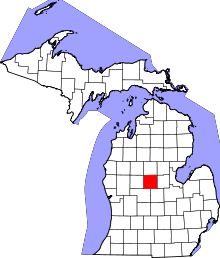 | |
| Villages | ||
| Charter township | ||
| General law townships | ||
| Unincorporated communities | ||
| Indian reservation | ||
| Footnotes | ‡This populated place also has portions in an adjacent county or counties | |