Weatherly, Pennsylvania
| Weatherly, Pennsylvania | |
|---|---|
| Borough | |
|
The former Schwab School | |
 Location of Weatherly in Carbon County | |
 Weatherly Location of Weatherly in Pennsylvania | |
| Coordinates: 40°56′25″N 75°49′36″W / 40.94028°N 75.82667°WCoordinates: 40°56′25″N 75°49′36″W / 40.94028°N 75.82667°W | |
| Country | United States |
| State | Pennsylvania |
| County | Carbon |
| Government | |
| • Mayor | Tom Connors |
| Area | |
| • Total | 2.98 sq mi (7.72 km2) |
| • Land | 2.98 sq mi (7.72 km2) |
| • Water | 0.0 sq mi (0.0 km2) |
| Elevation | 1,094 ft (333 m) |
| Population (2010) | |
| • Total | 2,525 |
| • Density | 848/sq mi (327.3/km2) |
| Time zone | EST (UTC-5) |
| • Summer (DST) | EDT (UTC-4) |
| ZIP code | 18255 |
| Area code(s) | 570 Exchange: 427 |
| Website |
www |

Weatherly a borough in Carbon County, Pennsylvania, United States, located 12 miles (19 km) northwest of Jim Thorpe and 28 miles (45 km) south of Wilkes Barre. Early in the twentieth century, there were silk mills, foundries, a candy factory, a fabricating plant, and a cigar factory. In 1900 2,471 people lived there, and in 1910, the population was 2,501. The population was 2,525 at the 2010 census.[1]
Originally called "Black Creek", it received a name change to "Weatherly" in 1848. Clock-maker David Weatherly, also an executive of the Beaver Meadow Railroad, made an agreement with the town that he would build them a clock if they would rename the town "Weatherly". They changed the name of the town to Weatherly, however David Weatherly skipped town without the promised clock. Charles and Eurana Schwab funded the clock that was built into the clock tower on top of the town's school, but the town kept the name Weatherly.
Geography
Weatherly is located in northwestern Carbon County at 40°56′25″N 75°49′36″W / 40.94028°N 75.82667°W (40.940257, -75.826722).[2] It is situated at an elevation of 1,100 feet (340 m) above sea level in the Ridge-and-Valley Province of the Appalachian Mountains, between Spring Mountain and Round Head Mountain to the north and Broad Mountain to the south.
According to the United States Census Bureau, the borough has a total area of 2.98 square miles (7.72 km2), all of it land.[1]
Demographics
| Historical population | |||
|---|---|---|---|
| Census | Pop. | %± | |
| 1870 | 1,076 | — | |
| 1880 | 1,977 | 83.7% | |
| 1890 | 2,961 | 49.8% | |
| 1900 | 2,471 | −16.5% | |
| 1910 | 2,501 | 1.2% | |
| 1920 | 2,356 | −5.8% | |
| 1930 | 2,531 | 7.4% | |
| 1940 | 2,754 | 8.8% | |
| 1950 | 2,622 | −4.8% | |
| 1960 | 2,591 | −1.2% | |
| 1970 | 2,554 | −1.4% | |
| 1980 | 2,891 | 13.2% | |
| 1990 | 2,640 | −8.7% | |
| 2000 | 2,612 | −1.1% | |
| 2010 | 2,525 | −3.3% | |
| Est. 2015 | 2,462 | [3] | −2.5% |
| Sources:[4][5][6] | |||
As of the census[5] of 2000, there were 2,612 people, 931 households, and 679 families residing in the borough. The population density was 866.8 people per square mile (335.0/km²). There were 1,033 housing units at an average density of 342.8 per square mile (132.5/km²). The racial makeup of the borough was 97.97% White, 0.27% African American, 0.08% Asian, 0.04% Pacific Islander, 0.23% from other races, and 0.42% from two or more races. Hispanic or Latino of any race were 0.69% of the population.
The most common ancestries in Weatherly is Italian (25.2%), Polish (15.8%), German (12.4%), Irish (10.9%), and Slovak (5.5%)
There were 931 households, out of which 32.9% had children under the age of 18 living with them, 57.9% were married couples living together, 11.5% had a female householder with no husband present, and 27.0% were non-families. 23.8% of all households were made up of individuals, and 13.7% had someone living alone who was 65 years of age or older. The average household size was 2.57 and the average family size was 3.03.
In the borough the population was spread out, with 23.0% under the age of 18, 5.8% from 18 to 24, 25.2% from 25 to 44, 22.1% from 45 to 64, and 23.9% who were 65 years of age or older. The median age was 42 years. For every 100 females there were 86.8 males. For every 100 females age 18 and over, there were 84.1 males.
The median income for a household in the borough was $38,219, and the median income for a family was $43,047. Males had a median income of $32,679 versus $21,607 for females. The per capita income for the borough was $16,192. About 8.7% of families and 10.8% of the population were below the poverty line, including 21.8% of those under age 18 and 3.9% of those age 65 or over.
Notable people
- Justin McCarthy, painter
- Thomas Jerome Welsh, bishop of the Roman Catholic Church from 1974 to 1997
Education
The Weatherly Area School District serves about 800 young students. The elementary and middle schools share one building while the high school is located just across the street.
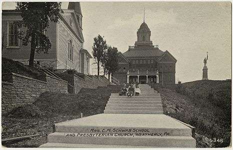 Presbyterian church, Schwab School and Civil War Memorial on an old postcard
 The borough hall now occupies the old railway station
 Post Office
References
- 1 2 "Geographic Identifiers: 2010 Demographic Profile Data (G001): Weatherly borough, Pennsylvania". U.S. Census Bureau, American Factfinder. Retrieved April 3, 2015.
- ↑ "US Gazetteer files: 2010, 2000, and 1990". United States Census Bureau. 2011-02-12. Retrieved 2011-04-23.
- ↑ "Annual Estimates of the Resident Population for Incorporated Places: April 1, 2010 to July 1, 2015". Retrieved July 2, 2016.
- ↑ "Census of Population and Housing". U.S. Census Bureau. Retrieved 11 December 2013.
- 1 2 "American FactFinder". United States Census Bureau. Retrieved 2008-01-31.
- ↑ "Incorporated Places and Minor Civil Divisions Datasets: Subcounty Resident Population Estimates: April 1, 2010 to July 1, 2012". Population Estimates. U.S. Census Bureau. Retrieved 11 December 2013.
External links
| Wikimedia Commons has media related to Weatherly, Pennsylvania. |
Municipalities and communities of Carbon County, Pennsylvania, United States | ||
|---|---|---|
| Boroughs | 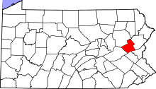 | |
| Townships | ||
| CDPs | ||
| Unincorporated communities | ||
| Footnotes | ‡This populated place also has portions in an adjacent county or counties | |