Trail blazing

Trail blazing, or trailblazing (way marking in United Kingdom and Ireland), is the practice of marking paths in outdoor recreational areas with blazes, markings that follow each other at certain—though not necessarily exactly defined—distances and mark the direction of the trail.
There are three main types of trail blazing: paint, carvings or affixed markers, with paint being the most widely used.
Types of blaze
Paint
A painted marking of a consistent shape or shapes (often rectangular), dimension and colour or combination of colours is used along the trail route. The system by which blazes are used to signify turns and endpoints in trails (see below) strongly favors the use of paint blazes.

European countries usually use systems of painted bars or shapes in more than one colour. The Central European Hiking Markers System is the most widely used standard. This system use three bars - usually one color in between two white bars, with different meanings attached to different colours - in a 10 cm x 10 cm square. Red is often used to mark difficult or summit trails.
Arrows of similar design signal a change of direction. Originally created in the Czech Republic, which has the densest hiking trail system in the world,[1] the standard spread to Slovakia, Poland, Croatia, Bosnia, Ukraine, Bulgaria, Georgia, Brazil and other countries, often thanks to European volunteers marking the trails around the world. Austrian and Swiss trails use a similar system of white and coloured stripes, with some differences from the Czech standard.
In the United States and Canada, it is a single colour, often white, red, blue or yellow. Trails in South Africa are often marked by yellow footprints painted on trees and rocks.
Before using paint on trees, it is sometimes necessary to clean the surface. One of the preferred techniques in the USA is to use a knife or drawknife to smooth the outer bark of trees without penetrating to the inner bark (so as to not injure the tree), then using an oil-based paint to create the blaze. Since paint introduces small amounts of potentially toxic chemicals into a protected environment, it is often preferred to keep the blazes small. Stencils are often useful, and sash brushes are the preferred brush type for precise work. Oil-based paint seems to last longer than latex-based and seems to be more benign to the bark. Blazes may also be painted on obvious rock surfaces or on posts set into the ground (or on utility poles, fences, or other handy surfaces) where the trail follows a road or goes through fields and meadows.
Carvings
in North America, Australia and New Zealand,[2] there are trails blazed by cuts made in bark by axe or knife, usually the former. Most often these are informal routes made by loggers or hunters, or trails descended from those routes. Originally a tree would be blazed by hatchet chops (still the dictionary definition) but today other methods have become more common, with environmental and aesthetic concerns sometimes playing a part in the choice of blazing method.[3] Other navigational aids, such as cairns, are used where blazes are unsuitable.
Affixed markers
.JPG)
Alternatively, plastic, metal or even sometimes wooden markers may be affixed to trees, usually with nails. These last longer than paint, but are vulnerable to both the chewing of animals (porcupines especially) and the growth of the tree, which causes the marker to fall off. To protect against this possibility, most markers are put on with some space between the head and the bark. The placement of markers requires more skill and labor than paint, as well as an area with an abundant supply of trees to which to attach them.
Flagging

Surveyor's tape hung from branches or tied around trees is sometimes used to indicate trail routes, but usually only for temporary or unofficial trails, most commonly when a trail route has been selected but the trail itself is under construction. Flags are sometimes used for permanent trails, but they are the most vulnerable to the elements of any trail blazing method and may be more difficult to see.
Trail flagging is the predominant method to mark a mountain hiking trail in Japan. Red ribbons usually indicate an ascent route while yellow ribbon indicate a descent route. On some mountains, a non-standard ribbon colour (white or blue) is used to identify a specific trail.
Other ways of marking trails
Cairns

Cairns are carefully arranged piles of stones. Cairns are are most commonly used to indicate trails in open areas, such as higher-elevation alpine areas, where no trees are available, or where conditions may make blazes hard to see.[4] An ancient example is the inuksuk (plural inuksuit), used by the Inuit, Inupiat, Kalaallit, Yupik, and other peoples of the Arctic region of North America. These structures are found from Alaska to Greenland. This region, above the Arctic Circle, is dominated by the tundra biome and has areas with few natural landmarks.
In the Presidential Range of New Hampshire's White Mountains, cairns are found at ten-foot (three-meter) intervals along trails above the tree line, so that hikers may find their way safely even if forced to crawl by heavy winds and harsh weather.
Below the tree line, cairns are used less frequently, often like flagging to indicate informal or unofficial paths or just their junctions with official trails. They may become obscured by snow in areas with heavy winters and may be easily knocked over. In some areas the recreational building of numerous cairns has obscured the proper use of cairns to mark junctions and crossings. In some areas of the United States, park rangers and land managers must disassemble excess cairns when they become eyesores or when they mislead navigation.
Where rocks are scarce poles can be used. Poles are also frequently used to mark ski and snow shoe trails.[5]

Trail ducks
While use of the term "duck" or "cairn" is somewhat regional, a duck is generally a much smaller rock pile,[6] typically stacked just high enough to convince the observer it is not natural. For most, two rocks stacked could be a coincidence, but three rocks stacked is a duck. In some regions, ducks also contain a pointer rock (or couple of stacked rocks) to indicate the direction of the trail.
Crosses
A wayside cross is a cross by a footpath, track or road, at an intersection, along the edge of a field or in a forest, which often serve as waymarks for walkers and pilgrims or designate dangerous places.[7] They are particularly common in Europe, for example in Germany, Galicia and the Alps. It can be made of wood, stone or metal. Most wayside crosses are designed as crucifixes.
Prominence
The amount of blazing used on a trail is often impacted by different land-management principles, as well as the kind of users the trail is likely to get and what kind of trail it is in the first place. In US wilderness areas, whether state or federal, the US Wilderness Act requires that the land seems "untrammeled by man," and so blazes are often kept to a minimum. Most wilderness trails are also used by serious hikers and backpackers who may find excessive blazing to be visually annoying or distracting.
By contrast, in a typical municipal or county park, or any land open to a wide variety of users, especially one where overnight camping is either forbidden or infrequent (for example, if it is located in a well-developed metropolitan area), one can expect much more casual users who are not used to finding trails and appreciate frequent blazes.
Single-track trails of the sort favored by those on foot also receive more blazes than those that follow old roads or other wide routes, which are often self-evident and are thus usually blazed only as necessary to infrequently reassure travelers of the route they have chosen.
Systems

On a large piece of land, there is likely to be more than one trail. While it might seem obvious that, at minimum, trails should at least take different colours, this is not always done. In Mount Greylock State Reservation, which contains the highest mountain in Massachusetts, all trails other than the Appalachian Trail use the same blue blaze.
Blaze type might also be mixed when different user groups (i.e., snowmobilers, horse riders, mountain bikers) are allowed on trails. For users of faster vehicles, blazes are often larger in order to be seen better at high speeds, and sometimes affixed markers best communicate who may and may not use a trail besides those on foot.
Another possible distinction is by season. In Norway, it is common to use blue for summer routes and red for winter routes. Red routes may traverse lakes and swamps, which are flat and well suited for cross-country skiing in winter, but impassable on foot in summer.
Colours are often assigned simply with an eye toward making sure that no two trails that intersect use the same one, but it can go further than that. On all state land in New York's Catskill Park, for instance, primary trails, especially longer "trunk trails" that go great distances, use red markers if they go in a generally east-west direction and blue if they go north-south. Shorter spur, loop or connector trails generally use yellow blazes.
On occasions when two trails run concurrently, usually at a slightly staggered junction, only one trail may be signed, often with the longer or more heavily trafficked trail's blaze predominating. In other cases, such as southern Vermont where the Appalachian Trail and the Long Trail follow the same path, both trails may use the same white blaze.
A quite different blazing system, called mute blazes was created in the Czech part of Krkonoše.[8] The blazes, cut out of sheet metal and painted red, are suspended on high poles, thus being visible to both hikers and skiers. Unlike in classic systems, they do not refer to paths or trails, but show the way to the nearest mountain huts and adjacent towns and villages with the possibility of overnighting and catering.[9]
National Trails in the United Kingdom generally use an acorn symbol. The National Cycle Network in the UK uses sculptural markers made of cast iron. The mark may also indicate the status of the route, for example in England yellow marks are used for footpaths, blue for bridleways, and red for byways open to all traffic.
Meaning of blazes

Even within the confines of a single trail, blazes may do more than simply reassure the trail user he or she is on the trail. They can alert the users to imminent turns, particularly if there is some confusion about what might be the trail, which can occur often in open woods, rocky open areas or on lightly used trails, switchbacks, and where trails begin and end.
Offset blazes, a system whereby a vertically stacked pair of blazes, with the upper one offset in the direction that the trail turns, was invented in 1969 by Bob Fuller, a volunteer for the New York-New Jersey Trail Conference. This system was first used in 1970 on the Beech Trail in Harriman State Park. This system was further refined to where a triangular pattern of blazes would indicate a terminus, its point up or down depending on whether that was the beginning or the end. These began to be used elsewhere and are now fairly common throughout North America, though variations of this system exist. Some trails instead use two blazes painted together at an angle to form an "L" shape to indicate a turn, with the angle between the two blazes indicating the angle and direction of the turn. Also, a few trails indicate turns with two stacked blazes, without an offset, but this can cause confusion as the direction is not implied. In addition, other trails may use two non-offset stacked blazes to indicate the trail goes straight at a location where there may be a tempting mis-turn.
A triangular pattern with its point to the side was also devised for eventualities like spurs or junctions, but these have not caught on.
In some areas, a triangular pattern with its point up indicates that a hiker is at the point of a sharp switchback.
As noted above, this system does much to encourage the use of paint blazes. Markers can also follow these patterns, but they less frequently use them. It cannot be used with cairns or tape flags, and not easily with carved blazes.
In the Netherlands, blazes usually consist of two bars above each other: white-red, yellow-red and red-blue are commonly seen blazes. An upcoming turn is indicated by duplicating the blazes: white-red-white-red, yellow-red-yellow-red, etc. Nowadays, stickers are often used, and instead of duplicating the blaze, the rectangle is cut into an arrow, to indicate direction. A saltire is used to indicate a direction should not be taken: the cross will have the same colours as the blazes (each bar will use a different colour).
Gallery
 A cairn trail marker on Snowbank Trail in Northern Minnesota.

 Trail marker Waitakere Ranges, New Zealand

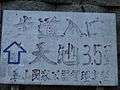 Ten-zi-trail entrance, Taiwan

 Trail marker on Australian bushwalking track, nailed to Scribbly Gum, Eucalyptus sclerophylla
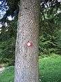 A blaze on a tree in Slovenia (the so-called Knafelc blaze, named after Alojz Knafelc)
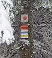
 Tourist trail signs for cycling (top) and hiking (bottom) in the Czech Republic
 An official NYSDEC marker in Catskill Park. Note protruding nail to allow for tree growth
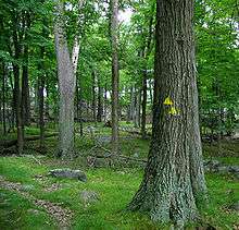
 Typical blaze on the Appalachian Trail
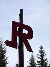
 A suburban tourist path in Police, Poland
 A cairn to mark the summit of a mountain, Graubuenden, Switzerland
 Swiss signpost: hiking trails in yellow, mountain path in white-red-white, Alpine Route in white-blue-white
 A marker post on Offa's Dyke Path, English/Welsh border
.jpg) Pilgrim path waymarker in Ireland.
Pilgrim path waymarker in Ireland. Trail blazing in Portugal (Sintra-Cascais NP). Shows: direction; route name; distance to; next POI. The small one: wrong direction
See also
- Daymark
- Land mark
- Quilt Trail
- Sea mark
- Wayfinding
- Waypoint, a GPS navigation term
References
| Wikimedia Commons has media related to Hiking and footpath signs. |
- ↑ http://blog.myczechrepublic.com/2006/10/31/czech-trail-marking-system-the-best-in-the-world/ Czech Trail Marking System the Best in the World
- ↑ › Mississippi › Fly Drives & Trails; ; ,
- ↑ See New American Oxford dictionary; Appalachian Trail Conservancy
- ↑ Appalachian Trail Conservancy
- ↑ Mount Seymour, BC, Canada
- ↑ How to Wilderness.com
- ↑ Sakrale Kleinbauten: Flurkreuze / Wegkreuze(PDF; 256KB) Redaktion: ibid Altbau AG, CH-Merkblätter des Bundesamtes für Bevölkerungsschutz, Kulturgüterschutz
- ↑ Narciarstwo biegowe w Karkonoszach [retrieved 2012-01-07]
- ↑ "Lyžařské stezky a jejich značení" (in Czech).