Washington State Route 104
| ||||
|---|---|---|---|---|
|
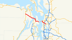
SR 104 is highlighted in red, with the ferry route being highlighted in pink. | ||||
| Route information | ||||
| Auxiliary route of US 101 | ||||
| Defined by RCW 47.17.175 | ||||
| Maintained by WSDOT | ||||
| Length: |
31.75 mi[1] (51.10 km) Mileage does not include ferry route | |||
| Existed: | 1964[2] – present | |||
| Major junctions | ||||
| West end: |
| |||
|
| ||||
| East end: |
| |||
| Location | ||||
| Counties: | Jefferson, Kitsap, Snohomish, King | |||
| Highway system | ||||
| ||||

State Route 104 (SR 104) is a 31.75-mile-long (51.10 km) state highway in the U.S. state of Washington, serving four counties: Jefferson on the Olympic Peninsula, Kitsap on the Kitsap Peninsula, and Snohomish and King in the Puget Sound region. It begins south of Discovery Bay at U.S. Route 101 (US 101) south of Discovery Bay and crosses the Hood Canal Bridge over Hood Canal to the terminus of SR 3 near Port Gamble. SR 104 continues southeast onto the Edmonds–Kingston Ferry to cross the Puget Sound and intersects SR 99 and Interstate 5 (I-5) before ending at SR 522 in Lake Forest Park. SR 104 also has a short spur route that connects the highway to SR 99 at an at-grade signal on the Snohomish–King county line.
Established during the 1964 state highway renumbering, SR 104 was formed out of four highways, themselves created in 1937: Secondary State Highway 9E (SSH 9E) from Discovery Bay to Port Gamble, Primary State Highway 21 (PSH 21) from Port Gamble to Kingston, SSH 1W within Edmonds, and SSH 2B from Edmonds to Lake Forest Park. PSH 21 was originally part of State Road 21, added to the state highway system in 1915 to connect the Port Gamble–Shine ferry to the Kingston ferry landing. The Edmonds–Kingston ferry at the end of State Road 21 has been in operation under various companies since 1923 and was served by the 14-car City of Edmonds. SSH 9E extended from Discovery Bay to Port Ludlow initially and was moved south and extended to the South Point ferry landing in the late 1940s. The bridge replaced the South Point–Lofall ferry when it opened in 1961, but the ferry was re-used during the construction of the second Hood Canal Bridge after the first bridge sank in 1979 and before the new bridge opened in 1982. The Edmonds–Kingston ferry was added to the state ferry system in 1951 before it was incorporated into SR 104 in 1994.
Route description

SR 104 begins at an intersection with US 101, located south of Discovery Bay on the Olympic Peninsula.[3] The highway travels south through rural Jefferson County towards Crocker Lake and turns southeast, intersecting SR 19 south of Port Ludlow. SR 104 continues east along the northern shore of Squamish Harbor, part of the Hood Canal, and crosses into Kitsap County on the 7,869-foot-long (2,398 m) Hood Canal Bridge, the third longest floating bridge in the world.[4] The highway serves as the northern terminus of SR 3 east of the bridge and turns northeast towards Port Gamble, located on the Kitsap Peninsula. SR 104 turns south along the western shore of Port Gamble, the bay the community is named after, and turns southeast to intersect SR 307.[5] The highway continues east from the intersection to Kingston, where it splits into a one-way pair before the designation travels onto the Edmonds–Kingston Ferry.[6][7]
The ferry, operated by Washington State Ferries (WSF), takes approximately 30 minutes to cross 5.95 miles (9.58 km) across Puget Sound. It departs from Kingston on Appletree Cove and arrives in Edmonds in Snohomish County.[8] WSF operates thirteen round-trip crossings every day.[9][10] Westbound passengers must pay a $7.70 toll or they may alternately pay with a prepaid Wave2Go card.[11]
SR 104 resumes in Edmonds on Main Street and crosses a BNSF rail line south of Edmonds Station.[12][13] The highway turns south at an intersection with SR 524 onto Sunset Avenue towards Woodway. The roadway travels southeast along Edmonds Way towards the Snohomish–King county line, intersecting SR 524 Spur and 5th Street at a grade-separated interchange. Edmonds Way travels through a partial cloverleaf interchange with SR 99 before SR 104 intersects its spur route, which travels west towards an at-grade signal with SR 99.[14] The highway continues east along Ballinger Way to a partial cloverleaf interchange with I-5 southeast of Lake Ballinger.[15] The highway travels southeast into Lake Forest Park, where SR 104 ends at SR 522 on the north shore of Lake Washington.[7]
SR 104 is considered, by the Washington State Department of Transportation (WSDOT), an auxiliary route of US 101, part of a numbering system established during the 1964 state highway renumbering.[16] Every year, WSDOT conducts a series of surveys on its highways in the state to measure traffic volume. This is expressed in terms of average annual daily traffic (AADT), which is a measure of traffic volume for any average day of the year. In 2011, WSDOT calculated that between 3,800 and 44,000 vehicles per day used the highway, mostly in the Shoreline area.[17] The Edmonds–Kingston ferry carried 3.808 million passengers and 2.025 million vehicles in 2012, according to WSF statistics.[18] The segments of the highway between Discovery Bay and Kingston and SR 99 and I-5 in Edmonds and Shoreline are designated as part of the National Highway System,[19] while the whole route is designated by WSDOT as a Highway of Statewide Significance because it connects major communities in the state of Washington.[20][21]
History

SR 104 was established during the 1964 state highway renumbering as the successor to several state highways: SSH 9E between Discovery Bay and Port Gamble, PSH 21 between Port Gamble and Kingston, SSH 1W in Edmonds, and SSH 2B between Edmonds and Lake Forest Park.[2][22][23] The highway between Port Gamble and Kingston was established in 1915 as part of State Road 21, which extended south to Bremerton.[24] During the creation of the Primary and secondary state highways in 1937, State Road 21 was re-designated as PSH 21 and extended south to Gorst.[25] SSH 9E was also established, connecting US 101 and PSH 9 in Discovery Bay to Port Ludlow, along with SSH 1W from US 99 and PSH 1 in Lynnwood through Edmonds to US 99 and PSH 1 in Woodway, following the route of an unpaved road built in the 1890s.[25][26] SSH 2B was created in 1937 to serve as a connector between US 99 and PSH 1 in Shoreline to a branch of PSH 2 in Lake Forest Park.[25]
SSH 9E was extended southeast to the South Point ferry over Hood Canal in 1947,[27] as the ferry traveled east to a branch of PSH 21 at Lofall created in 1949.[28][29] The highway was moved south from Discovery Bay to intersect US 101 near Crocker Lake in 1957 and was extended across the floating Hood Canal Bridge in 1959 to PSH 21 west of Port Gamble prior to the bridge opening on August 12, 1961.[30][31][32] SR 104 was designated over the highways in 1964 and was signed into law in 1970.[2][22] The Hood Canal Bridge, officially named after William A. Bugge, sank during the February 13, 1979 windstorm and was replaced by a ferry operating between Lofall and South Point until the west span was re-opened on October 23, 1982.[33][34][35] The east span of the bridge was replaced between 1997 and 2010, closing the bridge to traffic in May 2009 and re-opening the South Point–Lofall ferry.[36][37] The route of the highway has not been revised significantly since the 1994 inclusion of ferry routes.[38]
The Edmonds–Kingston ferry, added to SR 104 in 1994,[39] was first served by the 14-car and 76-passenger City of Edmonds in 1923.[40] The ferry ran three crossings on weekdays and six on weekends and a toll of $1.50 for vehicles and $0.25 for passengers was later charged.[40] After the establishment of Washington State Ferries in 1951, the 59-car MV Nisqually was assigned to the Edmonds–Kingston route. Between 1968 and 2005, the Evergreen State class MV Tillikum and MV Evergreen State were used on the route, while the Steel Electric class MV Illahee and MV Quinault were used on extra summer runs.[41] The Jumbo class MV Spokane and MV Walla Walla began serving the route in 2005,[42] but sometimes are replaced by other ferries, especially during maintenance.[9][10]
Spur route
| |
|---|---|
| Location: | Shoreline–Edmonds |
| Length: | 0.34 mi[1] (0.55 km) |
| Existed: | 2009–present[43] |

SR 104 Spur begins its short, 0.34-mile-long (0.55 km) route as 244th Street at SR 104 on the Snohomish–King county line between Edmonds and Shoreline.[1] 244th Street travels west on the 5-lane roadway (including a center turning lane) north of the Aurora Village shopping center to end at an intersection with Aurora Avenue, signed as SR 99.[14][44] The highway was originally part of SSH 2B from 1937 to 1964 and SR 104 after the 1964 highway renumbering and was created in 2009 after SR 104 was realigned onto a new divided highway.[23][29][43] WSDOT estimated that between 18,000 and 19,000 vehicles per day used the spur route, according to AADT data in 2011.[17]
Major intersections
| County | Location | mi[1] | km | Destinations | Notes |
|---|---|---|---|---|---|
| Jefferson | | 0.00 | 0.00 | Western terminus; interchange | |
| | 8.67 | 13.95 | Southern terminus of SR 19 | ||
| Hood Canal | 13.73– 14.53 | 22.10– 23.38 | Hood Canal Bridge | ||
| Kitsap | | 15.34 | 24.69 | Northern terminus of SR 3 | |
| | 20.38 | 32.80 | Northern terminus of SR 307 | ||
| Puget Sound | 24.40– 24.41 | 39.27– 39.28 | Mileage does not include ferry | ||
| Snohomish | Edmonds | 24.47 | 39.38 | Western terminus of SR 524 | |
| 25.09 | 40.38 | Southern terminus of SR 524 Spur | |||
| Woodway | 25.51 | 41.05 | 5th Avenue – Edmonds City Center | Interchange; westbound exit and eastbound entrance | |
| Snohomish–King county line | Edmonds–Shoreline city line | 27.78 | 44.71 | Interchange | |
| 28.11 | 45.24 | Eastern terminus of SR 104 Spur | |||
| Mountlake Terrace–Shoreline city line | 29.13 | 46.88 | Interchange | ||
| King | Lake Forest Park | 31.75 | 51.10 | Eastern terminus | |
| 1.000 mi = 1.609 km; 1.000 km = 0.621 mi | |||||
References
- 1 2 3 4 Staff (2012). "State Highway Log: Planning Report 2011, SR 2 to SR 971" (PDF). Washington State Department of Transportation. pp. 972–985. Retrieved January 27, 2013.
- 1 2 3 "47.17.175: State route No. 104". Revised Code of Washington. Washington State Legislature. 1994 [1970]. Retrieved January 27, 2013.
- ↑ "SR 101: Junction SR 104" (PDF). Washington State Department of Transportation. November 19, 1992. Retrieved January 27, 2013.
- ↑ "SR 104 - Hood Canal Bridge - By the Numbers". Washington State Department of Transportation. March 2010. Retrieved January 27, 2013.
- ↑ "SR 104: Junction SR 307" (PDF). Washington State Department of Transportation. August 20, 2002. Retrieved January 27, 2013.
- ↑ "SR 104: Junction SR 104 CO KNGSTN" (PDF). Washington State Department of Transportation. February 1, 2002. Retrieved January 27, 2013.
- 1 2 Google (January 27, 2013). "State Route 104" (Map). Google Maps. Google. Retrieved January 27, 2013.
- ↑ Edmonds/Kingston Route Map (Map). Washington State Ferries. Retrieved January 27, 2013.
- 1 2 "WSF Sailing Schedule for Edmonds / Kingston". Washington State Ferries. December 30, 2012. Retrieved January 27, 2013
- 1 2 "Winter 2013 Sailing Schedule: Edmonds / Kingston" (PDF). Washington State Ferries. December 30, 2012. Retrieved January 27, 2013.
- ↑ "Passenger and Vehicle Fares" (PDF). Washington State Ferries. May 1, 2012. Retrieved January 27, 2013.
- ↑ 2011 Washington State Rail System (PDF) (Map). Washington State Department of Transportation. January 2012. Retrieved January 27, 2013.
- ↑ Passenger Rail System - Washington State (PDF) (Map). Washington State Department of Transportation. January 2012. Retrieved January 27, 2013.
- 1 2 "SR 99: Junction SR 104 / SR 104 SP AURORA" (PDF). Washington State Department of Transportation. May 27, 2010. Retrieved January 27, 2013.
- ↑ "SR 5 - Exit 177: Junction SR 104 / NE 205th St" (PDF). Washington State Department of Transportation. October 19, 2011. Retrieved January 27, 2013.
- ↑ Terpening, Dustin (July 6, 2010). "Name that highway". The WSDOT Blog. Washington State Department of Transportation. Retrieved April 1, 2013.
- 1 2 Staff (2011). "2011 Annual Traffic Report" (PDF). Washington State Department of Transportation. pp. 133–136. Retrieved January 27, 2013.
- ↑ "WSDOT Ferries Division (WSF) - Nation's Largest Ferry System" (PDF). Washington State Department of Transportation, Washington State Ferries. January 2013. Retrieved January 27, 2013.
- ↑ National Highway System: Seattle, WA (PDF) (Map). Federal Highway Administration. October 1, 2012. Retrieved January 27, 2013.
- ↑ "Transportation Commission List of Highways of Statewide Significance" (PDF). Washington State Transportation Commission. July 26, 2009. Retrieved January 27, 2013.
- ↑ Lorenzo, Judy. "Highways of Statewide Significance". Washington State Department of Transportation. Retrieved April 1, 2013.
- 1 2 Prahl, C. G. (December 1, 1965). "Identification of State Highways" (PDF). Washington State Highway Commission, Department of Highways. Retrieved January 27, 2013.
- 1 2 Seattle, 1965 (JPG) (Map). 1:250,000. United States Geological Survey. 1965. Retrieved January 27, 2013.
- ↑ Washington State Legislature (March 19, 1915). "Chapter 53: Public Highways Appropriation". Session Laws of the State of Washington. Session Laws of the State of Washington (1915 ed.). Olympia, Washington: Washington State Legislature. p. 491. Retrieved January 27, 2013.
Section 5901-L. A secondary state highway is established as follows: State road No. 21: This road shall begin at Kingston, thence by the most feasible route through Port Gamble, Poulsbo and Bremerton to a connection with the Olympic Highway between Shelton and Hoodsport in Mason county.
- 1 2 3 Washington State Legislature (March 17–18, 1937). "Chapter 190: Establishment of Primary State Highways, Chapter 207: Classification of Public Highways". Session Laws of the State of Washington. Session Laws of the State of Washington (1937 ed.). Olympia, Washington: Washington State Legislature. pp. 941–942, 998, 1006. Retrieved January 27, 2013.
- ↑ Washington: Snohomish Quadrangle (JPG) (Map). 1:125,000. United States Geological Survey. October 1897. Retrieved January 27, 2013.
- ↑ State of Washington Department of Highways (1946–1947). "Chapter 232". Twenty-Second Biennial Report of the Department of Highways. Biennial Reports of the Department of Highways (1946 ed.). Olympia, Washington: Department of Highways. Retrieved January 27, 2013.
Secondary State Highway No. 9-E, from junction with Primary State Highway No. 9 in vicinity south of Discovery Bay by most feasible route to vicinity of South Point on Hood Canal.
- ↑ Washington State Legislature (March 22, 1949). "Chapter 225: Establishment of Primary and Secondary State Highways". Session Laws of the State of Washington. Session Laws of the State of Washington (1949 ed.). Olympia, Washington: Washington State Legislature. p. 774. Retrieved January 27, 2013.
Section 19. A primary state highway to be known as Primary State Highway No. 21, or the Kitsap Peninsula Highway, is hereby established according to description as follows: Beginning at Kingston, thence westerly and northerly by the most feasible route by way of Port Gamble, thence southerly by the most feasible route by way of the vicinity of Poulsbo and Bremerton to a junction with Primary State Highway No. 14, in the vicinity of Tidewater Creek; also beginning at Lofall on Hood Canal, thence by the most feasible route to a connection with Primary State Highway No. 21, as herein described.
- 1 2 Seattle, 1958 (JPG) (Map). 1:250,000. United States Geological Survey. 1958. Retrieved January 27, 2013.
- ↑ Washington State Legislature (1957). "Chapter 172". Session Laws of the State of Washington. Session Laws of the State of Washington (1957 ed.). Olympia, Washington: Washington State Legislature. p. 636. Retrieved January 27, 2013.
- ↑ Washington State Legislature (1959). "Chapter 319". Session Laws of the State of Washington. Session Laws of the State of Washington (1959 ed.). Olympia, Washington: Washington State Legislature.
- ↑ Hamilton, Charles (March 17, 2005). "Hood Canal Bridge opens on August 12, 1961.". HistoryLink. Retrieved January 27, 2013.
- ↑ Long, Priscilla (August 5, 2003). "Hood Canal Bridge sinks during a severe storm on Tuesday, February 13, 1979.". HistoryLink. Retrieved January 27, 2013.
- ↑ "Winds collapse Hood Canal Bridge". The Spokesman-Review. Spokane, Washington. February 14, 1979. p. 1. Retrieved January 27, 2013.
- ↑ "Hood Canal Bridge opens". Tri-City Herald. Kennewick, Washington. October 24, 1982. p. 7. Retrieved January 27, 2013.
- ↑ "SR 104 - Hood Canal Bridge Project - Complete March 2010". Washington State Department of Transportation. March 2010. Retrieved January 27, 2013.
- ↑ Morris, Jennifer (June 18, 2008). "Survey says: 'It's South Point to Lofall'". North Kitsap Herald. Poulsbo, Washington. Retrieved January 27, 2013.
- ↑ Washington State Highways, 2011–2012 (PDF) (Map). 1:842,000. Washington State Department of Transportation. 2011. Retrieved January 27, 2013.
- ↑ Washington State Legislature (March 30, 1994). "Chapter 209: Substitute House Bill 2618". Session Laws of the State of Washington. Session Laws of the State of Washington (1994 ed.). Olympia, Washington: Washington State Legislature. Retrieved February 1, 2013.
Sec. 3. RCW 47.17.175 and 1970 ex.s. c 51 s 36 are each amended to read as follows: A state highway to be known as state route number 104 is established as follows: also ((
Beginning at)) From the state ferry terminal at Kingston via the state ferry system easterly to the state ferry terminal at Edmonds; - 1 2 LeWarne, Charles (March 24, 2008). "The automobile ferry City of Edmonds makes its first run from Edmonds across Puget Sound to Kingston on May 20, 1923.". HistoryLink. Retrieved January 27, 2013.
- ↑ Demoro, Harre (1971). The Evergreen Fleet – A Pictoral History of Washington State Ferries. San Marino, California: Golden West Books. pp. 57–63. ISBN 0870950371.
- ↑ Brown, Charles E. (May 16, 2005). "Philip Spaulding, 92, designed state ferries, other vessels". The Seattle Times. Seattle. Retrieved January 27, 2013.
- 1 2 Staff (2009). "State Highway Log: Planning Report 2009, SR 2 to SR 971" (PDF). Washington State Department of Transportation. p. 5. Retrieved January 27, 2013.
- ↑ Google (January 27, 2013). "State Route 104 Spur" (Map). Google Maps. Google. Retrieved January 27, 2013.
External links
Former or proposed State Routes: SR 111 | ||