Wallkill Valley Rail Trail
| Wallkill Valley Rail Trail | |
|---|---|
|
| |
| Length | 23.7 miles (38.1 km)[1] |
| Location | Ulster County, New York[2] |
| Designation | National Recreation Trail, 2007[3] |
| Trailheads | |
| Use | Hiking, jogging, bike riding, horseback riding, and cross-country skiing. |
| Hiking details | |
| Sights | |
| Website | Wallkill Valley Rail Trail Association |
The Wallkill Valley Rail Trail is a 23.7-mile (38.1 km) rail trail and linear park that runs along the former Wallkill Valley Railroad rail corridor in Ulster County, New York. It stretches from Gardiner through New Paltz, Rosendale, and Ulster to the Kingston city line. The trail is separated from the Walden–Wallkill Rail Trail by two state prisons in Shawangunk, though there have been plans to bypass these facilities, and to connect the Wallkill Valley Rail Trail with other regional rail trails.
Plans to create the rail trail began as early as 1983, when New Paltz considered uses for the then-defunct Wallkill Valley corridor; the railroad had ceased regular traffic in 1977, and by 1983 had begun to remove its tracks. In 1991, a local land trust purchased the 12-mile (19 km) section of the former rail corridor between New Paltz and Gardiner, and conveyed the New Paltz section to the town and village of New Paltz. The trail was formally opened between New Paltz and Gardiner in 1993, though Gardiner did not purchase its section from the trust until 2007. The length of the trail was effectively doubled by a county land seizure in 2009, extending the walkway north from Rosendale through Ulster to Kingston. The extension included the Rosendale trestle, a 940-foot (290 m) bridge across the Rondout Creek. There are several other bridges that carry the trail, though none are as long.
The trail serves hikers, joggers, bikers, horseback riders, and cross-country skiers. It passes through several historic districts, such as Huguenot Street in New Paltz, and the Binnewater Historic District and Snyder Estate in Rosendale. The trail also traverses U.S. Route 44 (concurrent with State Route 55), and state routes 299 and 213. Several natural features are visible from clearing along the trail, such as the Shawangunk Ridge to the west, and the Plattekill Creek between New Paltz and Gardiner. The trail passes through dense vegetation, and is frequented by many types of animals and overwintering birds.
History
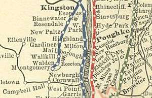
Stretching 33 miles (53 km)[5] from Montgomery to Kingston,[6] the Wallkill Valley Railroad operated from 1866[7] until its last regular freight run on December 31, 1977.[8] During the 1980s, its owner, Conrail, began to salvage the former corridor's steel rails and sell off sections of the rail bed.[9] State law mandated that in such sales, offers be made first to the state, then to the involved counties and municipalities.[10] The state bought a 1.4-mile (2.3 km) portion of rail bed between Shawangunk and Gardiner in November 1985 for the construction of the Shawangunk Correctional Facility in the hamlet of Wallkill.[11][12]
While Montgomery and Shawangunk purchased their sections of the railroad – 2.0 and 2.3 miles (3.2 and 3.7 km), respectively[13] – in 1985, eventually creating the 3.22-mile (5.18 km) Walden–Wallkill Rail Trail,[14][15] the towns of New Paltz, Gardiner and Rosendale initially declined to purchase their sections of the rail line.[16] The town of Shawangunk has been evaluating plans to bypass the state prison to connect the Walden–Wallkill and Wallkill Valley trails since 2004,[17] and such a connection was listed as a project in a 2008 county-wide transportation plan.[18] The latest proposal involves diverting the trail along Birch Road.[19] The Wallkill Valley Rail Trail was the seventeenth rail trail created in New York state,[20] and became a National Recreation Trail in 2007.[3]
New Paltz and Gardiner

Converting the former corridor to a rail trail was first considered in a 1983 environmental report commissioned by the town of New Paltz.[21] The study considered repurposing the corridor as a road for cars, but determined that the right-of-way, "lend[ing] itself to multiple and simultaneous 'people-oriented' transit", was "ideally suited for use as a trail for hiking, strolling, running, cycling and cross-country skiing".[22] In 1988, New Paltz invited a local non-profit, the Wallkill Valley Land Trust, to acquire the portion of the rail line between New Paltz and Gardiner. The Wallkill Valley Land Trust in turn requested assistance from The Trust for Public Land, and the purchase was completed on January 18, 1991.[23]
While the town and village of New Paltz immediately purchased their sections from the Wallkill Valley Land Trust – roughly 4 and 3 miles (6.4 and 4.8 km), respectively[24] – Gardiner did not purchase its 6-mile (9.7 km) section until much later.[25][26] Portions of the New Paltz–Gardiner section were informally open since June 1991, but the formal opening ceremony of the full 12.2-mile (19.6 km)[2] trail between New Paltz and Gardiner took place on October 9, 1993.[27]
The Gardiner section was in such a state of disrepair in 2004 that the Wallkill Valley Land Trust almost closed it.[28] Gardiner received a $100,000 grant from the New York State Office of Parks, Recreation and Historic Preservation in December 2006,[29] and the purchase was completed in 2007.[26] The state provided an additional $5,000 to maintain the trail.[30]
Purchasing the section allowed Gardiner to fix the drainage problems that had deteriorated the surface of the trail, and to ban the use of motor vehicles, something the Wallkill Valley Land Trust had not done. Though the section was worth $307,300, the Wallkill Valley Land Trust sold it to Gardiner for $70,000.[28]
In 2009 and 2010, the Tea Party movement held protests along the Gardiner section of the trail.[31] In November 2009, New Paltz received grants from the Greenway Conservancy, a state organization, to fund several rail trail–related projects. This included $17,750 to create a link[32] between the New Paltz section of the trail and the Hudson Valley Rail Trail in nearby Lloyd,[33] which was in turn being extended eastward to the Poughkeepsie Bridge;[32] the connection with the bridge was completed in October 2010.[34] The Wallkill Valley Railroad had considered such a connection after the bridge opened in 1889, but never built one.[35] The grants also included $7,000 to create 400 feet (120 m) of ADA-accessible trail, to connect the parking area of a local park, named after Sojourner Truth, with the rail trail.[32] The town had intended to connect the parking area with the trail since the late 1990s, but concerns over traffic, as well as state requirements, had added to the time and cost of the path; it was completed by June 2010.[36][37] The connections are part of a county-wide plan to create a bicycle path along NY 299, to link regional rail trails.[18]
Rosendale

The Rosendale portion of the rail bed runs 11.5 miles (18.5 km) from Rosendale through Ulster to Kingston and contains the 940-foot (290 m) Rosendale trestle.[1][38] The trestle rises 150 feet (46 m) above the Rondout Creek and State Route 213,[39] and also spans the former Delaware and Hudson Canal.[40] At the time of its construction it was the highest span bridge in the United States.[41]
Conrail sold the Rosendale section, including the bridge, in 1986 to a private businessman, John E. Rahl, for one dollar. Rahl maintained that the purchase granted him the right to "restore rail service on the whole Wallkill line",[24] and to joint ownership of Conrail.[42] Between 1989 and 1991, Rahl installed planking and guard rails on the southern half of the bridge,[43] which was then opened to the public.[27] He intended to allow bungee jumping off the bridge,[24][38] and did so until a January 1992 court order held that it violated zoning laws.[44][45] Douglas Hase, an entrepreneur who had run both bungee jumping and hot air ballooning companies,[46] tried unsuccessfully in 2003 and 2004 to get a variance for such a venture.[43][45][47]

After Rahl failed to pay $13,716 in property taxes over a period of three years,[38] Ulster County foreclosed on the 63.34-acre (25.63 ha) property on April 15, 2009. The Wallkill Valley Land Trust and Open Space Institute placed a bid on the land parcels comprising the Rosendale section on April 22, 2009,[48] and agreed to pay all outstanding taxes before receiving full ownership on July 8, 2009,[49] with the intention of adding it to the Wallkill Valley Rail Trail.[50] Following an engineering survey, the bridge was closed to the public in June 2009 for repairs.[51][52] Renovations were completed in 2013, allowing for the bridge to be opened to the public.
Canopy Development, a green development company from Northampton, Massachusetts,[53] owns a portion of the former rail bed in Rosendale. It has agreed to establish a right-of-way,[54] rerouting the trail to allow public access.[55] Another obstruction between Rosendale and Ulster is a private swimming pool, which will be bypassed.[56] The Mohonk Preserve and Open Space Conservancy were given a $20,000 state grant in March 2011 to maintain the portion of the trail by Kingston.[57] By the end of summer 2013, the last outstanding trail segment along the Rosendale-Kingston extension was opened to the public, completing the entire 23.7 mile rail trail.[4]
A regional business association has proposed a link between the trail, in Rosendale, and a series of regional rail trails. The proposal would create a 35-mile (56 km) network of rail trails across the towns of Marbletown, Rochester, and Wawarsing.[58] Several involved towns have been working toward accomplishing such a connection.[59]
Route

The trail begins at Denniston Road, in the southern part of the town of Gardiner.[60] Movement farther south is impossible, because the corridor south of Denniston Road is fenced off by barbed wire.[61] After roughly 1 1⁄2 miles (2.4 km), it crosses Sand Hill Road before approaching the hamlet of Gardiner at the 2 1⁄2-mile (4.0 km) mark. Once in the hamlet, the trail intersects U.S. Route 44 (concurrent with State Route 55).[60]
Located within the hamlet are a defunct, former dairy creamery and the site of the former Gardiner railroad station.[62] Built in 1881[63] and opened the following year, the creamery was one of the dairies that transported its products to New York City by way of the Wallkill Valley Railroad.[62] It was originally the property of the Borden family, but closed in the 1920s,[63] and has since been renovated as an apartment complex.[28] The former Gardiner railroad station ceased operations when the rail line closed. It became a sporting goods store by 1981,[64] a video store by the early 1990s,[65] and an antique store by 1995.[66] The station burned down on October 10, 2002.[65]
The trail crosses Phillies Bridge Road 1 mile (1.6 km) north of the hamlet, with an overpass carrying the trail over Forest Glen Road 3⁄4 mile (1.2 km) farther. The road overlies the Catskill Aqueduct and Delaware Aqueduct.[67] Originally supported by trestles and a stone foundation, the overpass was rebuilt in 1910 during the construction of the Catskill Aqueduct. The reconstruction removed the trestles and added a concrete foundation. Though a local legend holds that the bridge was originally built in response to the death of a prominent woman at the Forest Glen railroad crossing, it is more likely that it was built to maintain the rail line at a consistent grade.[68] A little over 1⁄10 mile (0.16 km) from the bridge is the site of the former Forest Glen station.[69] The trail crosses Bridge Creek Road and Old Ford Road about 1⁄4 and 1 mile (0.40 and 1.61 km) from the Forest Glen bridge, respectively, before entering the town of New Paltz.[67]
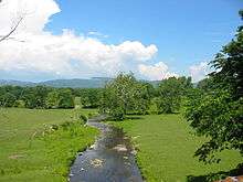
Shortly after entering New Paltz, the trail crosses a bridge over Plattekill Creek.[67] The masonry for the bridge was completed by late June 1870,[70] and trestle work was done by July.[71] Originally made of wood, the bridge was accidentally set on fire in 1880 by ashes or sparks from a passing train. This prompted the railroad to coat its rail ties with tin while replacing its wooden bridges with ones made of stone.[72][73] The bridge's original abutments were made of Shawangunk conglomerate. It was rebuilt in 1912, and crosses the Plattekill Creek at a height of 35 feet (11 m).[74] The Shawangunk Ridge is visible from the bridge.[67]
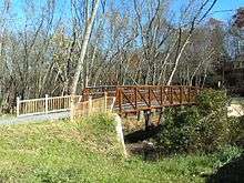
Plains Road is shortly after the bridge, and the trail continues for 3⁄10 mile (0.48 km) before crossing Cedar Lane. It crosses Plains Road again after another 1 1⁄5 miles (1.9 km), reaching the Sojourner Truth park in the village of New Paltz.[75] The trail is connected to the park via a small footbridge constructed in 2010 by the Alexandria, Minnesota–based construction company Contech. It has a weight limit of 5 short tons (4.5 t)[37][76] and is able to withstand earthquakes.[77]
At the edge of the park, the trail crosses Water Street and enters the Water Street Market, a "restored area of boutiques, galleries, and cafés". It then crosses State Route 299 and passes La Stazione, the former railroad station.[75] The refurbished depot had been originally built in 1870,[78] rebuilt after a 1907 fire,[79] and sold to private interests in 1959.[80] The building was in a state of disrepair by the early 1980s,[81] but renovated in 1988[82] and converted to an Italian restaurant in 1999.[83] Over the next 1⁄2 mile (0.80 km), the trail passes North Front Street, Broadhead Avenue, and Mulberry Street. After another 1⁄2 mile (0.80 km) the trail traverses Huguenot Street,[75] a historic district containing colonial-era stone houses. Some of the houses date to the late 1600s.[84]

About 1 mile (1.6 km) from Huguenot Street, the trail reaches the 413-foot (126 m) Springtown bridge spanning the Wallkill River.[85] The bridge was originally made of wood and completed by the middle of December 1870,[72][86] but was rebuilt between 1880 and 1881, using iron, by Clarke, Reeves & Co.[87] It was rated by the superintendent of the Wallkill Valley Railroad to be safe for rail traffic as fast as 40 miles per hour (64 km/h).[88] The bridge's decking and benches were put in place in 1993 by volunteers and members of the nearby Hutterite community in the hamlet of Rifton.[89] The design of the bridge's railings was influenced by equestrians to better accommodate horses.[21] Immediately after the bridge is Springtown Road.[75]
The trail continues west of the Wallkill River. Roughly 1 1⁄2 miles (2.4 km) from the Springtown bridge, the trail crosses Cragswood Road. Another 3⁄10 mile (0.48 km) farther, it reaches the New Paltz–Rosendale boundary line, continuing another 3 miles (4.8 km) on formerly private property to Mountain Road in the hamlet of Rosendale.[90] Restorations to the Rosendale trestle were completed, and the bridge was opened to the public in June, 2013.[91] This added 11 1⁄2 miles (18.5 km) over the Rondout Creek to Kingston,[52] crossing Interstate 87 and terminating by State Route 32.[92] The extension passes through the town of Ulster and includes four small bridges between Rosendale and Kingston.[93]
Recreation
The road between the former railroad station and Water Street Market was the first site of a new town crosswalk system that opened on March 29, 2008.[94] Under the new system, pedestrians can use flags placed in roadside containers to signal traffic.[95] The trail connects with the Sojourner Truth park, which has had access to the Wallkill River for kayaking and canoeing since April 27, 2003.[96] The Minnewaska Preserve and Mohonk Preserve, featuring 60 miles (97 km) of combined walkways, can be reached through New Paltz.[97] In the past, students at nearby SUNY New Paltz have used the trail for "legend[ary,] massive keg parties [and] ... opportunities to be romantic".[98] As part of an August 2010 art exhibit depicting concealed weapons laws, the Samuel Dorsky Museum of Art placed pieces of the exhibit throughout areas of New Paltz expected to have heavy pedestrian traffic, including the rail trail.[99]

The trail connects to the Binnewater Historic District in Rosendale. The district was the location of several local quarries which opened throughout the region after the 1825 discovery of rocks capable of producing Rosendale cement in the nearby hamlet of High Falls. At its peak, the district was producing 4,000,000 barrels a year and employed 5,000 people.[100]
Though the Binnewater rail station was once part of the historic district,[101] it was located too close to Binnewater Road and was hit repeatedly by trucks until it fell apart in May 1989. The station was subsequently demolished by the county highway department.[102] Another historic district, the Snyder Estate, runs along the Rosendale section. The Snyder Estate is a former mining site once used by all four major regional cement producers.[101] The Rosendale trestle has been the site of numerous picnics, barbecues, and at least one wedding. One person has tried bungee jumping off the bridge without a restraining cord.[103]
Several shale outcrops are visible along the trail,[104] with views of the Shawangunk Ridge to the west;[105] the skytop tower of the Mohonk Mountain House is visible on one of the cliffs.[106] Parking for the trail is provided at a municipal lot on Farmers Turnpike in Gardiner.[107] In New Paltz, there are parking lots at the Sojourner Truth park,[32] off Springtown Road, at the Huguenot Historical Society, and at a Board of Cooperative Educational Services (BOCES) conference center. The trail runs parallel to state routes 208 and 32;[108] there are two park and rides on Route 32,[109] a 63-spot lot in New Paltz,[110] and a 58-spot lot in Rosendale.[111] There are two bicycle shops along the trail in both Gardiner and New Paltz.[112]
Flora and fauna

Flora along the northern end of the trail includes sumac (Rhus) and honeysuckle (Lonicera) shrubs, American elm (Ulmus americana), bigtooth aspen (Populus grandidentata) and quaking aspen (Populus tremuloides). As the trail approaches Gardiner to the south, there are occurrences of sugar maple (Acer saccharum), American beech (Fagus grandifolia), tulip-tree (Liriodendron tulipifera) and black birch (Betula lenta).[74] Other trees common on the trail include red maple (Acer rubrum), shagbark hickory (Carya ovata), northern pin oak (Quercus ellipsoidalis), eastern red cedar (Juniperus virginiana), white ash (Fraxinus americana) and eastern white pine (Pinus strobus).[113]
Many animals pass through the trail unobserved, leaving behind tracks. This includes bears, deer, coyotes, dogs, bobcats, cats, skunks and rabbits.[113] Several bird species overwinter in the region and can be observed from the trail, such as the mourning dove (Zenaida macroura), blue jay (Cyanocitta cristata), bluebird (Sialia), cardinal (Cardinalis cardinalis), starling (Sturnus vulgaris), downy woodpecker (Picoides pubescens), American goldfinch (Spinus tristis), tufted titmouse (Baeolophus bicolor), black-capped chickadee (Poecile atricapillus), sparrow (Passer) and purple finch (Carpodacus purpureus).[114]
See also
- Walden–Wallkill Rail Trail – the southern continuation of the former rail corridor
References
- 1 2 "Wallkill Valley Rail Trail Length Doubles". Open Space Institute. 2009-08-31. Retrieved 2010-11-01.
- 1 2 "History of the Trail". Wallkill Valley Rail Trail Association. Retrieved 2010-11-01.
- 1 2 "2007 National Recreation Trail designations". National Trails System. Retrieved 2010-11-04.
- 1 2 Woods, Lynn (2013-09-13). "Rosendale link completes 24-mile stretch of rail trail". Almanac Weekly. Retrieved 2014-06-11.
- ↑ Mabee 1995, p. 40
- ↑ Mabee 1995, pp. 50–51
- ↑ Mabee 1995, p. 10
- ↑ Mabee 1995, p. 135
- ↑ Mabee 1995, p. 139
- ↑
- "§ 18 Acquisition of abandoned railroad transportation property". Transportation Law. New York State Legislature. Retrieved 2011-04-03.
- "Railroad Corridor Abandonment in New York State" (PDF). NYS OPRHP. Retrieved 2010-11-02.
- ↑ Mabee 1995, pp. 140, 142
- ↑ "Shawangunk Correctional Facility" (PDF). Prison Visiting Project. Correctional Association of New York. July 2009. p. 1. Retrieved 2010-11-02.
- ↑ Mabee 1995, p. 142
- ↑ "Park Description and Program Schedules" (PDF). Walden, NY: Village of Walden Recreation and Parks. Retrieved 2010-12-26.
- ↑ Mabee 1995, pp. 140, 144
- ↑ Mabee 1995, pp. 140–141
- ↑ Sisson, Angela; Hitchings, Crystal; Clague, Joshua (March 2004). "Town of Shawangunk Open Space Inventory and Analysis" (PDF). Conway, MA: Conway School of Landscape Design. pp. 68–69. Retrieved 2010-11-01.
- 1 2 "Ulster County Non-Motorized Transportation Plan" (PDF). Kingston, NY: Ulster County Transportation Council. December 2008. pp. 27, 29, 31, 37, 41. Retrieved 2010-11-07.
- ↑ Rowley, Chris (2010-08-12). "A New Use for Prison Farmlands: Can Prison Lands Serve to Connect the Rail Trail System?". Shawangunk Journal. Ellenville, NY: Electric Valley Media LLC. Retrieved 2011-02-21.
- ↑ Mabee 1995, p. 143
- 1 2 Penna & Sexton 2002, p. 182.
- ↑ "Report on Potential Public Use of the Abandoned Conrail Right-of-Way". New Paltz Environmental Conservation Commission. August 1983.
- ↑ Mabee 1995, pp. 141–143
- 1 2 3 Mabee 1995, p. 141
- ↑ "State money will help expand rail trail in Gardiner". Times Herald-Record. Middletown, NY: Dow Jones Local Media Group. 2006-12-30. Retrieved 2010-11-02.
- 1 2 "Wallkill Valley Rail Trail in Gardiner". Wallkill Valley Land Trust. Retrieved 2010-11-02.
- 1 2 Mabee 1995, p. 144
- 1 2 3 "Acquisition and Development of the Gardiner Rail Trail" (PDF). Acquisition Application 2006 EPF Grant. NYS OPRHP. 2006-05-26. pp. 1–7. Retrieved 2010-11-07.
- ↑ "Office of Parks, Recreation and Historic Preservation 2006 Trail Grant Awards" (Press release). NYS OPRHP. 2006-12-29. Retrieved 2010-11-06.
- ↑ Bonacic, John J. (2007-04-02). "Bonacic Gives Ulster County Budget Report" (Press release). New York State Senate. Retrieved 2010-11-06.
- ↑
- Horrigan, Jeremiah (2009-04-14). "Tax Day Tea Parties set to protest bailouts". Times Herald-Record. Middletown, NY: Dow Jones Local Media Group. Retrieved 2010-11-06.
- "Calendar: July 4, 2010". Daily Freeman. Kingston, NY: Journal Register Company. 2010-07-04. Retrieved 2010-11-06.
- 1 2 3 4 "Ulster Trail Projects Receive Greenway Support" (Press release). Albany, NY: Hudson River Valley Greenway. 2009-11-06. Retrieved 2010-11-03.
|first1=missing|last1=in Authors list (help) - ↑ Costantino, Claire R.; Bigelow, Joe (2009-12-12). "A Brief History of the Hudson Valley Rail Trail" (PDF). Hudson Valley Rail Trail. p. 1. Retrieved 2010-11-03.
- ↑ Labrise, Megan (2010-10-07). "Happy trails: Rail Trail East links hamlet with Walkway". New Paltz Times. Kingston, NY: Ulster Publishing. Retrieved 2011-01-11.
- ↑ Mabee 1995, p. 80
- ↑ Kemble, William J. (2010-03-03). "New Paltz footbridge project nearing completion". Daily Freeman. Kingston, NY: Journal Register Company. Retrieved 2010-11-03.
- 1 2 Kemble, William J. (2010-06-25). "New Paltz footbridge will open path to rail trail". Daily Freeman. Kingston, NY: Journal Register Company. Retrieved 2010-11-03.
- 1 2 3 Bosch, Adam (2009-06-01). "Wallkill Rail Trail could double in size". Times Herald-Record. Middletown, NY: Dow Jones Local Media Group. Retrieved 2010-11-01.
- ↑ "Rosendale trestle closed for improvements". Daily Freeman. Kingston, NY: Journal Register Company. 2010-06-13. Retrieved 2011-04-03.
- ↑ Mabee 1995, pp. 18–20
- ↑ "A Bit of Extraordinary Railroad History–The Great Rosendale Bridge of the Wallkill Valley Railroad–Other Railroad Items". The New York Times. New York, NY: Arthur Ochs Sulzberger, Jr. 1872-03-19. Retrieved 2010-11-03.
- ↑ Rahl, John (1998-04-15). "Re: Finance Docket No. 33388 Joint Ownership of Conrail" (PDF). Retrieved 2010-11-23.
- 1 2 "Minutes of the April 20, 2004 Meeting". Zoning Board of Appeals Minutes. Town of Rosendale. 2004-04-20. Retrieved 2010-11-04.
- ↑ Rowe, Pat (2004-04-21). "Foes jump all over Rosendale bungee plan". Daily Freeman. Kingston, NY: Journal Register Company. Retrieved 2010-11-22.
- 1 2 "Minutes of the May 20, 2003 Meeting". Zoning Board of Appeals Minutes. Town of Rosendale. 2003-12-16. Retrieved 2010-11-04.
- ↑
- Zezima, Katie (2005-10-30). "Carolyn Kaplan and Douglas Hase". The New York Times. New York, NY: Arthur Ochs Sulzberger, Jr. Retrieved 2010-11-22.
- Kladko, Brian (2006-12-31). "Balloon operator gets hot over trade secret battle". Boston Business Journal. Boston, MA: American City Business Journals. Retrieved 2010-11-22.
- ↑ Rowe, Pat (2004-04-16). "Leap of faith: Bungee jumping may come to Rosendale". Daily Freeman. Kingston, NY: Journal Register Company. Retrieved 2011-04-03.
- ↑ "Ways and Means Committee Minutes for April 15, 2009" (PDF). Ulster County. 2009-05-07. Retrieved 2010-11-04.
- ↑ "Resolution No. 215 Authorizing The County Commissioner Of Finance To Accept Bids On Parcels Of County Owned Property To Be Used For Public Use And Benefit And Authorizing The Chairman To Convey Property To Open Space Conservancy, Inc., And Wallkill Valley Land Trust, Inc." (PDF). Ulster County. 2009-07-22. Retrieved 2010-11-04.
- ↑ "New Addition to the Wallkill Valley Rail Trail". New Paltz, NY: Wallkill Valley Land Trust. August 2009. Archived from the original on July 6, 2010. Retrieved 2010-11-01.
- ↑ "Hanging by a Thread: Engineers Start Inspection on the Railroad Bridge" (Press release). Open Space Institute. 2010-11-15. Retrieved 2010-11-18.
- 1 2 Bosch, Adam (2010-06-12). "Rosendale trestle section of Wallkill Rail Trail to be shut down for repairs". Times Herald-Record. Middletown, NY: Dow Jones Local Media Group. Retrieved 2010-11-01.
- ↑ Woods, Lynn (2009-07-13). "Canopy Resort Would Bring Upscale Ambience to Rosendale". HV BIZ. White Plains, NY: Westfair Business Publications. Retrieved 2010-11-01.
- ↑ "Meeting Minutes, November 16, 2009 UC Trails Advisory Committee" (PDF). Ulster County. 2009-11-16. p. 2. Retrieved 2010-11-07.
- ↑ Botton, Sari (2007-09-23). "With an Upscale Spa, a Clash of Meanings for the Word 'Green'". The New York Times. New York, NY: Arthur Ochs Sulzberger, Jr. Retrieved 2010-11-23.
- ↑ Bosch, Adam (2009-06-10). "Hudson Bureau Confidential: Completing the Wallkill Valley Rail Trail". Times Herald-Record. Middletown, NY: Dow Jones Local Media Group. Retrieved 2010-11-01.
- ↑ Bosch, Adam (2011-03-15). "More than $158,000 for land trusts in mid-Hudson, Catskills". Times Herald-Record. Middletown, NY: Dow Jones Local Media Group. Retrieved 2011-03-15.
- ↑ Kemble, William J. (2010-07-11). "Business group will help link Ulster County rail trails". Daily Freeman. Kingston, NY: Journal Register Company. Retrieved 2011-03-02.
- ↑ Schoenfeld, Gregory (2010-09-16). "The Trail to Recovery: The RVBA Leads the Way to a Continuous Rondout Valley Rail Trail". Shawangunk Journal. Ellenville, NY: Electric Valley Media LLC. Retrieved 2011-03-02.
- 1 2 Perls 2003, p. 340.
- ↑ Penna & Sexton 2002, p. 191.
- 1 2 Mabee 1995, pp. 90–95.
- 1 2 Penna & Sexton 2002, p. 190.
- ↑ Mabee 1995, p. 137
- 1 2 Mabee 2003, p. 22.
- ↑ Mabee 1995, p. 152
- 1 2 3 4 Perls 2003, p. 341
- ↑ Mabee 1995, p. 72
- ↑ Penna & Sexton 2002, p. 189.
- ↑ New Paltz Times. New Paltz, NY. 1870-06-30. Missing or empty
|title=(help) - ↑ New Paltz Independent. New Paltz, NY. 1870-07-14. Missing or empty
|title=(help) - 1 2 Mabee 1995, pp. 12–13
- ↑ Mabee 1995, p. 61
- 1 2 A placard affixed to the Plattekill Creek bridge by the Wallkill Valley Rail Trail Association.
- 1 2 3 4 Perls 2003, p. 342
- ↑ A placard affixed to the bridge.
- ↑ Alter, Maxim (2010-03-05). "De-Railed on the Trail". New Paltz Oracle. 81 (17). New Paltz, NY: SUNY New Paltz. p. 5. Retrieved 2010-11-26.
- ↑ New Paltz Times. New Paltz, NY. 1870-09-01. Missing or empty
|title=(help) - ↑ New Paltz Independent. New Paltz, NY. 1907-12-31. Missing or empty
|title=(help) - ↑ "'No Bar in R.R. Station', Zoning Bd. Of Appeals". New Paltz News. New Paltz, NY. 1977-04-13.
- ↑ Muise, Jeff (1984-01-25). Times Herald-Record. Middletown, NY: Dow Jones Local Media Group. p. 30. Missing or empty
|title=(help) - ↑ "New Paltz rail station to become real estate office". Huguenot Herald. 1988-01-07.
- ↑ "Pasta junction – on the right track in New Paltz". Times Herald-Record. Middletown, NY: Dow Jones Local Media Group. 1999-07-02. p. 24.
- ↑ "Trail of the Month: October 2002". Rails-to-Trails Conservancy. Retrieved 2010-11-05.
- ↑ Chazin 2001, pp. 289–290.
- ↑ New Paltz Independent. New Paltz, NY. 1870-12-15. Missing or empty
|title=(help) - ↑ Documents of the Senate of the State of New York. 2. Albany, NY: Weed, Parsons and Company. 1885. p. 320.
- ↑ Mabee 1995, pp. 128–130
- ↑ Mabee 1995, pp. 143–144.
- ↑ Perls 2003, pp. 342–343
- ↑ "Rosendale trestle opens to public, extending rail trail". Daily Freeman. 2013-06-30. Retrieved 2014-06-11.
- ↑ "Double 'Wow" on Rail Trail: Rosendale Railroad Span, Extension to Open Saturday". Poughkeepsie Journal. June 25, 2013. Retrieved July 14, 2013.
- ↑ Schoenfeld, Gregory (2010-05-27). "Extended Wallkill Valley Rail Trail Will Span Historic Rosendale Trestle". Shawangunk Journal. Ellenville, NY: Electric Valley Media. Retrieved 2011-02-11.
- ↑ Burke, Caitlin (2008-04-03). "Village of New Paltz Introduces PedFlags". New Paltz Oracle. 79 (18). New Paltz, NY: SUNY New Paltz. Retrieved 2010-11-19.
- ↑ Story, Victoria (2008-03-27). "Flags to Aid Pedestrian Safety". New Paltz Oracle. 79 (17). New Paltz, NY: SUNY New Paltz. Retrieved 2010-11-19.
- ↑ Nyquist, Tom; Cotton, Tom; Danskin, Vici (2003-04-24). "Mayor Nyquist Encourages Voting". New Paltz Oracle. 74 (21). New Paltz, NY: SUNY New Paltz. Retrieved 2010-11-19.
- ↑ "Wallkill Valley Rail Trail". Rail Trails in New York. A1 Trails. May 2003. Retrieved 2010-11-09.
- ↑ Phillips, Eldon (2004-05-06). "Rail Trail Provides Escape to Nature". New Paltz Oracle. 75 (22). New Paltz, NY: SUNY New Paltz. Retrieved 2010-11-19.
- ↑ Alter, Maxim (2010-11-11). "'Carrying' a Cause for the Community". New Paltz Oracle. 82 (8). New Paltz, NY: SUNY New Paltz. p. 6B. Retrieved 2010-11-24.
- ↑ Larson, Neil G. (September 1982). "Binnewater Historic District" (Java). National Register of Historic Places Registration. NYS OPRHP. p. 5. Retrieved 2010-11-09.
- 1 2 "Snyder Estate Natural Cement Historic District" (Java). National Register of Historic Places Registration. NYS OPRHP. 1992. pp. 2, 19, 22. Retrieved 2010-11-09.
- ↑ Mabee 1995, p. 140
- ↑ Genero 2005, p. 9.
- ↑ "Ten Terrific Rail & Canal Trails in New York" (PDF). Albany, NY: Parks & Trails New York. p. 4. Retrieved 2010-11-05.
- ↑ "Wallkill Valley Rail Trail". New York – New Jersey Trail Conference. Retrieved 2010-11-05.
- ↑ Chazin 2001, p. 289.
- ↑ "Frequently Asked Questions". Town of Gardiner. Retrieved 2010-11-05.
- ↑ "The Wallkill Valley Rail Trail" (PDF). Wallkill Valley Rail Trail Association. p. 2. Retrieved 2010-11-19.
- ↑ "The Ulster–Poughkeepsie Link and MTA Metro-North Railroad" (PDF). MTA. p. 1. Retrieved 2010-11-19.
- ↑ Rife, Judy (2009-06-08). "New parking lot wins raves in New Paltz". Times Herald-Record. Middletown, NY: Dow Jones Local Media Group. Retrieved 2011-01-01.
- ↑ "Ulster County Commuter Parking Facilities Capacity Analysis and Needs Assessment" (PDF). Ulster County. 2008-12-17. p. 3. Retrieved 2011-01-01.
- ↑ Byrons, Leah (2009-04-29). "Hit the bike trail". Hudson Valley Parent. Retrieved 2010-11-12.
- 1 2 "Nature on the Trail". Wallkill Valley Rail Trail Association. Retrieved 2010-11-02.
- ↑ Bowdery, Lynn; Elwell, Ruth. "Winter Birds on the Rail Trail". Wallkill Valley Rail Trail Association. Retrieved 2010-11-02.
Bibliography
- Chazin, Daniel D. (2001). New York Walk Book: A Companion to the New Jersey Walk Book (7th ed.). Mahwah, NJ: New York – New Jersey Trail Conference. ISBN 1-880775-30-1.
- Genero, Peter P. (2005). Thank Rosendale: New York – The Empire State. Fort Pierce, FL: Genero Inc. ISBN 0-9759419-1-7.
- Mabee, Carleton (1995). Listen to the Whistle: An Anecdotal History of the Wallkill Valley Railroad. Fleishmanns, NY: Purple Mountain Press. ISBN 0-935796-69-X.
- Mabee, Carleton (2003). Gardiner and Lake Minnewaska. Mount Pleasant, SC: Arcadia Publishing. ISBN 0-7385-1185-4.
- Penna, Craig Della; Sexton, Tom (2002). The Official Rails-to-Trails Conservancy Guidebook. Guilford, CT: Globe Pequot Press. ISBN 978-0-7627-0450-7.
- Perls, Jeffrey (2003). Shawangunks Trail Companion: A Complete Guide to Hiking, Mountain Biking, Cross-Country Skiing, and More Only 90 Miles from New York City. Woodstock, VT: Countryman Press. ISBN 978-0-88150-563-4.
External links
| Wikimedia Commons has media related to Wallkill Valley Rail Trail. |
- Wallkill Valley Rail Trail Association – Founded and maintains the Wallkill Valley Rail Trail
- Route of the trail
- Route of the Rosendale-Kingston extension
Coordinates: 41°44′11″N 74°05′50″W / 41.736333°N 74.097118°W
| Albany |
|    |
|---|---|---|
| Allegany | ||
| Cattaraugus | ||
| Cayuga | ||
| Columbia | ||
| Delaware | ||
| Dutchess | ||
| Franklin | ||
| Livingston | ||
| Monroe |
| |
| New York | ||
| Ontario | ||
| Orange | ||
| Oswego | ||
| Putnam | ||
| Rockland |
| |
| St. Lawrence | ||
| Schenectady | ||
| Ulster | ||
| Westchester | ||
| Wyoming | ||