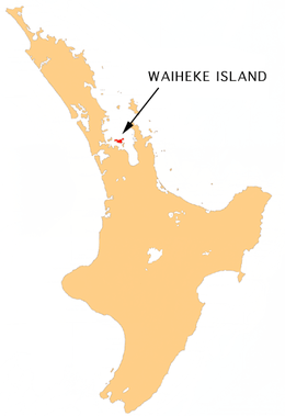
Waiheke Island
| Waiheke (Māori) | |
|---|---|
 Landsat image of the island, August 2002 | |
 | |
| Geography | |
| Location | Hauraki Gulf |
| Coordinates | 36°48′S 175°06′E / 36.800°S 175.100°ECoordinates: 36°48′S 175°06′E / 36.800°S 175.100°E |
| Archipelago | New Zealand archipelago |
| Area | 92 km2 (36 sq mi) |
| Length | 19.3 km (11.99 mi) |
| Width | 0.64–9.65 km (0.40–6.00 mi) |
| Coastline | 133.5 km (82.95 mi) |
| Highest elevation | 231 m (758 ft) |
| Highest point | Maunganui |
| Administration | |
|
New Zealand | |
| Regional Council | Auckland Region |
| Demographics | |
| Population | 9,150 (June 2016) |
| Pop. density | 99.5 /km2 (257.7 /sq mi) |
| Ethnic groups | New Zealanders |
Waiheke Island (/waɪˈhɛkiː/; Māori: [ˈwaihɛkɛ]) is in the Hauraki Gulf of New Zealand. Its ferry-terminal in Matiatia Bay at the western end is 21.5 km (13.4 mi) from the downtown terminal in Auckland—measured on GPS by Fullers Ferry captains.
It is the second-largest island in the gulf, after Great Barrier Island. It is the most populated, with nearly 8,730 permanent residents plus another estimated 3,400 who have second or holiday homes on the island.[1] It is New Zealand's most densely populated island, with 93 people/km², and the third most populated after the North and South Islands. It is the most accessible island in the Gulf, with regular passenger and car ferry services, a Waiheke-based helicopter operator, and other air links.[2] In November 2015, Waiheke Island received international attention when it was rated the fifth best destination in the world to visit in 2016 by Lonely Planet[3] and also voted the fourth best island in the world in the Condé Nast Best Islands in the World List[4]
Geography
Overview
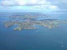
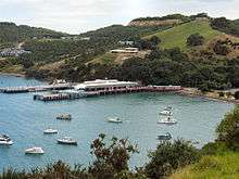
The island is off the coast of the North Island. It is 19.3 km (12.0 mi) long from west to east, varies in width from 0.64 to 9.65 km (0.40 to 6.00 mi), and has a surface area of 92 km2 (36 sq mi). The coastline is 133.5 km (83.0 mi), including 40 km (25 mi) of beaches. The port of Matiatia at the western end is 17.7 km (11.0 mi) from Auckland and the eastern end is 21.4 km (13.3 mi) from Coromandel.[2] The much smaller Tarahiki Island lies 3 km (1.9 mi) to the east.
The island is very hilly with few flat areas, the highest point being Maunganui at 231 m (758 ft).[5] The climate is slightly warmer than Auckland, with less humidity and rain and more sunshine hours.[2]
Geology
There are locations of interest to geologists: an argillite outcrop in Rocky Bay,[6] and a chert stack at the end of Pohutukawa Point, considered as "one of the best exposures of folded chert in Auckland City".[7]
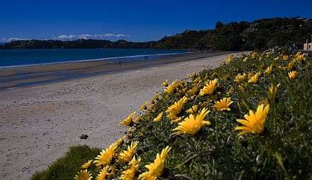
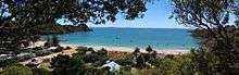
Beaches
There are many scenic beaches, including:
- Oneroa Beach – The main beach, on the northern side of the town of Oneroa.
- Little Oneroa Beach – A small secluded beach at the east end of Oneroa Beach, separated by a protruding cliff wall.
- Palm Beach – Similar in shape to Oneroa Beach (complete with protruding cliff wall at the east end that separates a small private beach in Boatshed Bay), it gets its name from the mature phoenix palms at the east end.
- Little Palm Beach – A small clothes-optional beach at the west end of Palm Beach.
- Blackpool Beach – The south-facing counterpart of Oneroa Beach, lining Blackpool and popular for kayaking and windsurfing.
- Surfdale Beach – A zoned-in beach on the southern side of Surfdale, separated from Blackpool Beach by a small protruding peninsula, which has a scenic unsealed route called The Esplanade linking the beaches. Popular for kitesurfing.
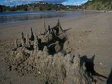
- Onetangi Beach – A 1.87 km long, north-facing beach lining Onetangi. For many years it has been the site of the Onetangi Beach Races. Its western end, often inaccessible at high tide, is clothes-optional. It has sandcastle building contests annually; participants have a few hours to build their creations in soft sand that is free of shells and suitable for digging.
- Cactus Bay – Considered by many Waihekeans as the most perfect beach and, with nearby Garden Cove, a romantic place for picnicking. The beach is accessible only by boat or kayak, as its land access was blocked off by a private landowner.
- Shelly Beach – A small and well sheltered shell and stone beach located between Oneroa and Ostend. It has free BBQ facilities and a diving platform located just off shore. It's a popular choice with families as at high tide, it is often very calm and flat - ideal for children.
Climate
Located in the Hauraki Gulf, Waiheke Island, like Auckland, experiences a subtropical climate according to the Trewartha climate classification, or an oceanic climate according to the Koeppen climate classification. The region lies 13° of latitude south of the Tropic of Capricorn, so tropical plants which are protected for the winter months will flower and fruit in the summer, and cold climate vegetables planted in autumn will mature in early spring. Summers tend to be warm and humid, while winters are relatively mild with frost being a rare event on Waiheke.
Rainfall is typically plentiful, though dry spells may occur during the summer months which can be problematic for many of the island residents, the vast majority of whom rely on Rainwater harvesting from residential roofs for drinking and household water usage. During such dry periods, typically 3 – 4 months of the year between December to March, the island's several water delivery trucks can be seen (and often heard) busily replenishing residential water tanks that have run empty.
It is often anecdotally said by locals that Waiheke has a micro-climate which differs to that of other parts of the Auckland Isthmus. Though little factual data appears to exist to support this, the below-listed climatic data taken from a recent NIWA report [8][9] does suggest Waiheke receives over 100 hours more per year of sunshine than other parts of Auckland. Detailed monthly climate data, such as air temperature, sea temperature and wind speeds is needed but does not appear to be readily available.
| Annual Mean Temperature | Annual Precipitation | Annual Sunshine Hours |
|---|---|---|
| 15.2c | 1461mm | 2100 |
History
The original Maori name for Waiheke was apparently Te Motu-arai-roa, "the long sheltering island"[10] but at the time the first European visitors arrived it was known as Motu-Wai-Heke, "island of trickling waters"[10] - rendered as Motu Wy Hake by James Downie, master of the store ship HMS Coromandel, in his 1820 chart of the Tamaki Strait and the Coromandel coast.[10]
Demographics
Population
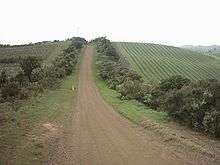
Waiheke has a resident population of 8,340 people (2013)[11] with most living close to the western end,[12] or near the isthmus between Huruhi Bay and Oneroa Bay, which at its narrowest is only 600 metres wide.[13] The settlements of Oneroa and Blackpool are the furthest west, followed by Palm Beach, Surfdale, and Ostend. Further east lies Onetangi, on the northern coast of the wide Onetangi Bay.[13] To the south of this on the opposing coast is Whakanewha Regional Park, Whakanewha, and Rocky Bay (sometimes very erroneously called Omiha, for which there is no historical provenance). Much of the eastern half of the island is privately owned farmland[13] and vineyards.
Waiheke is a popular holiday spot, and during the main summer season, especially around Christmas and Easter, its population increases substantially due to the number of holiday homes being rented out, corporate functions and dance parties at vineyards and restaurants, the Wine Festival and the Jazz Festival and weekend trippers from around the country and the world. The population increases significantly, rents go up, almost all homes and baches are full and a festive atmosphere exists.
Social composition
The demographic composition is 90.5% European, 11.4% Maori, 4% Pacific Islander and 2% Asian. 27% of residents were born outside New Zealand.[1]
Socially the island is highly diverse, with the creative sector (artists, musicians, scientists, writers, poets and actors) and eccentrics strongly represented.[13] It has 1,206 businesses but around 1,000 people commute daily to Auckland[13] as career opportunities are limited. 60.9% of the residents are in employment.[11] The main employment sectors are hospitality (23%) and retail (15%) followed by education, agriculture/horticulture and healthcare (10% each).[1] Gentrification and land speculation is having an impact, with high rates and mortgage interest rates forcing some people on fixed incomes to relocate.[14] New Zealand council rates are based on land and building valuations, which take into account potential value for redevelopment even if the owners live on the property and have no intention to sell or redevelop.[15] The cost of living is higher compared to the mainland, due to the shipping freight costs of most foodstuffs, fuel and amenities.
The income distribution (2001 Census) shows a higher proportion of lower income groups and a lower proportion of higher income groups compared to the whole of Auckland City. This is partially due to a higher number of pensioners and single parent families who are usually on fixed incomes and poorer. In 2001, the median income for those older than 15 was $15,600 compared to $23,500 in 2006. In 2013 the median personal income was $27,200,[11] slightly lower than the Auckland median at $29,600 due to a larger number of pensioners over 65 in the demographic pyramid. The median household income was relatively low, at $51,100 per annum, compared to $76,500 in Auckland as a whole. The increase in wealth on Waiheke is also reflected in the number of families earning more than $100,000 per year, which has more than doubled in 2007 since 2001.[16]
Māori relations
Race relations are supportive, by New Zealand standards. The local marae was not ancestral Māori land held in Māori title but belonged to the Waiheke County Council. Its citizens, both Pākehā and Māori, got together, arranged for a long-term lease of council-owned land and built the marae. One of the earliest Māori land claims was driven by Waiheke citizens, who at the time did not know who the tangata whenua Māori were for the island.[17]
Lifestyle
Waiheke's lifestyle is largely influenced by the fact that it is surrounded by water - there are a number of beaches mentioned above, that are popular for a wide range of activities such as kite surfing, kayaking, stand-up-paddle boarding, boating, swimming and other typical beach pursuits.
Arts & Culture
Waiheke has its own community run cinema,[18] a theatre[19] that hosts a number of regular musicians, performances and local productions and a library[20] that was recently rebuilt in 2014 at the cost of $6million[21]
There are also a large number of art galleries run by private individuals across the island, along with a community art gallery[22]
Sports
Waiheke has a number of sports teams and facilities on the island. Rugby union, cricket, rugby league, football and netball are widely played and followed.
There are three main facilities on the island: Onetangi Sports Park, Ostend Sports Park and an indoor facility at The Waiheke Recreation Centre[23]
There are several sports teams on the island, with Waiheke United AFC[24] hosting a number of football or soccer teams, from First Kicks (4 -9yr olds) through to senior men's teams. Waiheke Rugby Club also has a large presence and following on the island,[25] as do netball and indoor football teams.
Governance

Waiheke is part of the territorial authority of Auckland. From 1970 until its amalgamation with Auckland City in 1989, it was administered by the Waiheke County Council. Since 1989 there has been an elected community board with limited, mainly representational powers, in line with other neighbourhoods in Auckland City. One member on the City Council represented all the inhabited Hauraki Gulf islands (i.e. Waiheke, Great Barrier and Rakino) plus the downtown area in the central business district.
Amalgamation with Auckland City, later Auckland Council
In 1989 Waiheke County Council was forcibly amalgamated with Auckland City Council as part of Local Government restructuring of that year. Pundits predicted a stormy relationship.
In 1990 the Waiheke Community Board formally requested the right to de-amalgamate from the City. A 'De-amalgamation Committee' was established by Council to facilitate the Board's wish. However, this proved not to be to the liking of most of Auckland's citizens. In 1991, the city responded to a campaign run by a pro-union group, the Waiheke Island Residents & Ratepayers Association (Inc) by holding a democratic referendum. The de-amalgamation proposal sponsored by the Community Board was defeated.[26]
The subject of amalgamation is still a hot topic on the island. In 2008, the Royal Commission on Auckland Governance received 3,537 submissions, 615 of which were made by Waihekeans, over 1/6 of all submissions.[27] A public meeting of 150 residents on 29 March 2008 found a majority in favour of breaking away from Auckland City.[28]
The Royal Commission[29] recommended that Waiheke Island retain its community board with enhanced powers. The Waiheke Local Board was elected in the October 2010 Auckland local elections as part of the Auckland Council.[30]
The 2010 local elections resulted in Waiheke resident Mike Lee becoming the Councillor for the Waitemata and Gulf Ward. Denise Roche, Faye Storer, Jo Holmes, Don McKenzie and Jim Hannan were elected to the new Local Board. After Roche's resignation after becoming a Member of Parliament for the Green Party of New Zealand in 2011, Paul Walden was elected in a by-election.
In 2013 Lee was re-elected. Paul Walden was re-elected to the Local Board, joined by Beatle Treadwell, Becs Ballard, John Meeuwsen and Shirin Brown.
Transport
Ferry
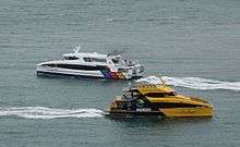
Scheduled ferry services regularly sail to and from Waiheke. Fullers operate passenger services from Downtown Auckland to Waiheke's Matiatia wharf, with trips taking approximately 40 minutes. Meanwhile, SeaLink provides passenger, car and freight services between Half Moon Bay in East Auckland and Waiheke's Kennedy Point, with trips taking around 50 minutes to an hour. SeaLink also offer a passenger and car "City Service" connecting Kennedy Point with Auckland's Wynyard Quarter.
There have been several attempts to provide alternative passenger ferry services from Matiatia. Most recently, New Zealand tour cruise company Explore Group provided a Matiatia to Downtown service from late 2014 until April 2016. The competition was welcomed by Waiheke residents, but ultimately proved unsustainable for the company.[31][32]
In recent years, there has been significant controversy with many of Waiheke's resident population who rely on the ferries "like buses" - and especially those who commute daily to work in Auckland - complaining of poor parking arrangements at Matiatia,[33] unfair price increases[34] and generally poor ferry services.[35] This led to the launch of a Ferry User's Group [36] (or FUG) and a "Fuller's Watch" group,[37] with the objective of giving a voice to the island's ferry passengers whilst lobbying local politicians and working with the ferry companies to improve the overall experience.
Air service
There is one airport on the island, Waiheke Island Aerodrome, served via fixed-wing aircraft by Flight Hauraki and via helicopter by a number of operators.[38] Waiheke is also accessible via a regular seaplane service.[39]
Infrastructure
The island has less infrastructure than mainland Auckland. The roads are mainly narrow and in many places unsealed and unlit, especially on the eastern half of the island. The Waiheke Bus Company (owned by Fullers) services most inhabited parts of the island, linking to the ferry sailings from Matiatia.
Waiheke is connected to the North Island's electricity network via twin 33 kV undersea cables from Maraetai on the mainland, terminating on the island at a 33/11 kV substation in Ostend.[40] Each house must maintain its own water supply, most collecting rainwater in cisterns, and must install a septic tank and septic field to handle sewage. This is a requirement in every building consent.[41]
A fibre optic cable running from a bay on the southern side of the island connects it to the internet. Internet services are provided using VDSL and ADSL, with fibre optic rollouts planned for some areas. Internet speeds are significantly higher in the more developed western side of the island. A locally owned WISP provides internet, however prices are significantly higher than DSL and fibre based competitors.[42]
The community established a charitable trust which bid on Auckland City's contract for solid waste disposal. After winning the bid, it was implemented with such success that the recycling centre soon had to be expanded to handle the volumes.[43]
The island has a lively press, with two weekly newspapers vying for attention: the long-established independently-owned Waiheke Gulf News and the Fairfax Media owned Waiheke Marketplace. A community radio station, Waiheke Radio, is broadcasting on 88.3 FM and 107.4 FM after Beach FM lost its licence in a commercial bid in 2008.
Education
Waiheke Island has two primary schools and one secondary school. It is the only island in New Zealand, other than the North and South Islands, with a secondary school.
- Te Huruhi School is a state contributing primary (Year 1–6) school in Surfdale, and has 425 students.[44] It opened in 1986 following the split of Waiheke Area School.
- Waiheke High School is a state Year 7–13 secondary school in Surfdale, and has 499 students.[44] It opened in 1986 following the split of Waiheke Area School.
- Waiheke Primary School is a state full primary (Year 1–8) school in Ostend, and has 227 students.[44] It opened in 2005.
Significant events
Stony Batter WWII fortifications
During World War II, three gun emplacements were built on the eastern edge to protect Allied shipping in Waitemata Harbour, in the fear that Japanese ships might reach New Zealand. This mirrored developments at North Head and Rangitoto Island. The guns were never fired in anger. The empty emplacements and the extensive tunnels below them can be visited seven days a week.[45]
Nuclear and GE free zone
Waiheke was the first community in New Zealand to vote for a nuclear free zone and this action is said to have contributed to the national decision to become nuclear-free under David Lange's government.
In 1999 Waiheke's community board voted Waiheke as a "genetic engineering free zone",[46] but this is a matter of principle rather than fact, as only national government controls exist over genetically engineered foods and grains.
Matiatia redevelopment
The gateway to Waiheke, where the main pedestrian ferry lands over 1 million passengers per year, is a valley and harbour called Matiatia. In 2000 it was purchased by three investors in Waitemata Infrastructure Ltd (WIL). In 2002 WIL proposed to change the Operative District Plan rules for their land to build a major shopping and hotel complex with 29,000 m2 (312,153 sq ft) of gross floor area on buildable land of approximately 3 hectares. This united the residents of the island in opposition. Over 1,500 adult residents of the island (out of perhaps 3,000) joined together in an incorporated society, the Community and People of Waiheke Island (CAPOW),[47] to oppose the private plan change in court. Church Bay resident and former newsreader John Hawkesby became "the voice of the campaign" that included a showdown with then mayor, John Banks, when Hawkesby made a deputation to the city council hours after the press revealed that Banks was in business with two (of three) directors of WIL. To paraphrase the NZ Herald article, Banks stated that he had no financial interest in Waitemata Infrastructure Ltd, but the revelation required that he leave the council chamber before the appearance of a deputation of island residents on the issue. Hawkesby said to the remaining councillors "The appearance of a conflict of interest looms large given the business relationship of the mayor with the principals of Waitemata Infrastructure." and "The people of Waiheke are furious, both at the duplicity of the process and the standing orders which permit such secretive conduct of officers and two councillors."
In 2004, they won an interlocutory judgement in which the environment court ruled that Auckland City Council had erred in the rules, and the current rules limited controlled development to 5,000 m2 (53,820 sq ft) in what was called the Visitor Facility Precinct. In 2005, CAPOW won an interim judgement by the court which reduced the proposed redevelopment to about ⅓ of what the investors had originally sought.(see Decision A-055-2005)
This set the stage for confidential negotiations between Auckland's mayor Dick Hubbard and the investors, who on 31 August 2005 (now known as 'Matiatia Day' on the island) sold 100% of the stock in WIL to the city for $12.5 million. The unanimous vote on 30 June 2005 of the City Council to approve the purchase was said to have come about because of the unity of the people of Waiheke Island. The court case finally was concluded with permitted development set at 10,000 m2 of mixed use gross floor development. The Court also found Auckland City Council and WIL liable for costs in relationship to the interlocutory judgement. Since WIL was now owned by Council, it had to write a cheque to CAPOW for $18,000, representing 75% of CAPOW's costs on that matter. This final cheque allowed CAPOW to pay all its debts and balance its books.
The Council organised a design competition in 2006 to find a suitable development plan and project for the Matiatia gateway. The competition winner's design (scheme 201) is available for comment on the Council website.[48] It has already attracted much criticism for the lack of car parking close to the ferry terminal, the transport hub function used by all islanders regularly and almost daily by around 850 commuters to Auckland.[49]
In 2013, Matiatia again became a hotspot for controversy as a group of residents proposes a private marina at the terminal. Some of the veterans of the protests a decade prior (led by local resident, retired newsreader John Hawkesby), re-emerged to oppose.[50] The Environment Court decided in favour of the residents.
Headland: Sculpture on the Gulf
Waiheke has become internationally known for the biennial Headland: Sculpture on the Gulf, an “outdoor sculpture exhibition set on a spectacular coastal walkway on Waiheke Island in Auckland’s Hauraki Gulf”.[51] It takes place towards the end of January until approximately mid February every other year. It was listed by the New York Times as no. 35 in its list of 46 must see places and events for 2013.[52] The sculpture walk attracts thousands of visitors to Waiheke, for example, more than 30,000 people walked the sculpture walk in 2013.[53]
Wine
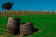
Waiheke has become known as New Zealand's "island of wine," home to a dedicated group of winegrowers who have successfully matched the maritime climate and ancient soil structures to the selection of classical grape varieties to produce red and white wines with distinctive varietal character.
The climate is well suited to growing Bordeaux wine-type grapes, though some Chardonnay and Sauvignon blanc varieties are also considered to be good. Waiheke winegrowers regularly win awards for Syrah (Kennedy Point's 2007 Syrah won best Syrah in the world in 2009), proving the island's terroir suits it well.
The local wines are relatively expensive because of the limited size of many of the vineyards.[54]
Among the vineyards and wineries on Waiheke Island are:
- Awaroa Vineyard – The organic Awaroa vineyards lie on west-facing slopes among native bush in the middle of Waiheke Island. Syrah and Cabernet Sauvignon are the main varieties planted.
- Batch Winery - Waiheke's newest hi tech winery production is located at the highest vineyard with views from Coromandel to the Sky Tower. Batch wine portfolio includes Flora, Pinot Gris, Cabernet Sauvignon and Syrah. Batch Fizz sparkling wine, made and bottled on site, range includes Fizz Rose, Fizz Chardonnay and Fizz Riesling.
- Cable Bay Vineyards – Cable Bay Vineyards makes wines from grapes grown on Waiheke Island and in Marlborough. Varieties grown include Gewürztraminer, Sauvignon blanc, Pinot noir, Chardonnay, Five Hills Merlot/Malbec/Cabernet and Rosé.
- Destiny Bay Vineyards – Destiny Bay is Waiheke Island's only Cabernet blend specialist and first fully certified sustainable winery.[55] The 2007 Magna Praemia is New Zealand's highest rated wine by an international critic, and received 98/100 points by Anthony Dias Blue.[56][57] Magna Praemia is New Zealand's most expensive wine.[58]
- Edbrooke Vineyard – Jeremy Edbrooke has over 7 acres (28,000 m2) planted in Merlot, Cabernet Franc, Chardonnay and Pinot gris grapes which are supplied to Waiheke Island's Passage Rock Wines.
- Fenton Estate – First planted in 1989, Fenton Twin Bays Vineyard is a north-facing property that spans two small bays separated by a peninsula.
- Goldwater Estate – Begun by pioneering Waiheke winemakers Kim and Jeanette Goldwater, Goldwater Estate was among the first wine making operations on Waiheke. Its awards[59] include being named winery of the year by Wines and Spirits Magazine in 2001.
- Jurassic Ridge – Jurassic Ridge is a small, family-owned vineyard and winery, named for the surrounding geology. It produces hand-crafted Syrah, Montepulciano, Pinot gris and Cabernet Franc. Jurassic greywacke is a major feature of the terroir.
- Kennedy Point Vineyard – Kennedy Point Vineyard is the only certified organic vineyard on Waiheke and can be found on the southwestern side and was established in 1996. It specializes in growing and producing Bordeaux and Syrah wines.
- Man o'War – Situated at the northern end of Waiheke Island, the Man o'War vineyards are planted on numerous small sites on the 5,000-acre (20 km2) Man o'War farm.
- Miro Vineyard – Miro Vineyard produces two wines, both red Bordeaux blends. The vineyard overlooks the ocean at Onetangi Beach.
- Mudbrick Vineyard – Mudbrick is one of the Waiheke's best known wineries and has a Provence-style restaurant made of mudbrick. The vineyard produces Merlot, Chardonnay, Cabernet Sauvignon, and Syrah grapes.
- Obsidian Vineyard – Obsidian Vineyard in Onetangi. It is a 17-hectare property established in 1993. Obsidian, its flagship wine, is a blend of Cabernet Sauvignon, Merlot, Cabernet Franc and Malbec. Its label is "Weeping Sands" (the translation of "Onetangi"). In 2007 Obsidian won a trophy and gold medal[60] at the Romeo Bragato National Wine Competition for its first release of the Montepulciano variety.
- Passage Rock Wines – Passage Rock Vineyard is at the eastern end of Waiheke Island at the head of Te Matuku Bay. Its first vines were planted in 1994.
- Peacock Sky – Peacock Sky Vineyard is located in the centre of Waiheke Island with views across the Hauraki Gulf to Auckland.
- Peninsula Estate on Hakaimango Point was planted in 1986/87. These original plantings of Cabernet Sauvignon, Cabernet Franc, Merlot and Malbec, also now include Chardonnay and Syrah.
- Poderi Crisci Estate
- Stony Batter Estate – Stony Batter Estate, the island's largest vineyard, is at the north-eastern corner of the island
- Stonyridge Vineyard – Stonyridge was founded in 1981 in the Onetangi Valley. Specializing in Bordeaux-style reds, the vineyard's most famous wine is its Stonyridge Larose.
- Tantalus Estate
- Te Motu Vineyard – Te Motu Vineyard was established in the Onetangi Valley in 1989. The first vintage was produced in 1993.
- Te Whau Vineyard
- The Hay Paddock – This 12-acre (49,000 m2), stone-walled vineyard on Seaview Road is planted in Syrah vines sourced from the Hermitage AOC region of the Rhone Valley. Cellar-aged collector wines are released under the Harvest Man and Hay Paddock labels.
- Topknot Hill Vineyard
- View East Vineyard – A boutique vineyard on the south eastern corner of Waiheke Island specializing in Syrah.
- Woodside Hill
See also
References
- 1 2 3 Waiheke Demographic Report Card 2011
- 1 2 3 "Waiheke Island information". Tourism Auckland. Retrieved 19 April 2016.
- ↑ The best places in the world to travel in 2016
- ↑ Best Islands in the World: Readers' Choice Awards 2015
- ↑ Waiheke & adjacent islands (map information from the DOC, via Craig Potton Publishing website)
- ↑
- ↑ Appendix 3 – Character statements for conservation areas (from the Auckland City District Plan – Hauraki Gulf Islands Section – Proposed 2006). Accessed 2008-02-12.
- ↑ "Auckland Climate" (PDF). NIWA. Retrieved 21 October 2015.
- ↑ "Statistics for the 2011 Annual Climate Summary" (PDF). NIWA. Retrieved 21 October 2015.
- 1 2 3
- 1 2 3 Auckland Council Waiheke snapshot
- ↑ Stony Batter Historic Reserve, Waiheke Island. Department of Conservation.
- 1 2 3 4 5 "Community". Tourism Auckland. Retrieved 13 November 2010.
- ↑ "Seniors advocate rate revolt island-wide and beyond". Waiheke Gulf News. May 2006.
- ↑ "Board reiterates valuation concerns Board reiterates valuation concerns". Waiheke Gulf News. March 2006.
- ↑ "Editorial: Better educated and better off". Waiheke Gulf News. 5 July 2007.
- ↑ Report of the Waitangi Tribunal on the Waiheke Island Claim. Waitangi Tribunal. Accessed 2008-08-22.
- ↑ Waiheke Cinema
- ↑ Artworks Theatre
- ↑ Waiheke Library
- ↑ Stuff article
- ↑ Waiheke Art Gallery
- ↑ Waiheke Recreation Centre
- ↑ Waiheke United
- ↑ Waiheke Rugby
- ↑ "NZ Herald 6 December 1991"
- ↑ "Royal Commission allocates one day to Waiheke". Waiheke Gulf News. 5 June 2008.
- ↑ "A show of hands says it all". Waiheke Gulf News. 3 April 2008.
- ↑ Royal Commission Executive Summary report
- ↑ "Waiheke local board". Auckland Council. Retrieved 14 November 2010.
- ↑ Waiheke commuters hail ferry competitor
- ↑ "Explore No More". Archived from the original on 27 April 2016. Retrieved 30 June 2016.
- ↑ Matiatia parking concerns
- ↑ Fed up with ferry price hikes
- ↑ Ferry users make waves, company pledges change
- ↑ Ferry User's Group
- ↑ Fuller's Watch
- ↑ "Air Transport". Auckland Tourism, Events and Economic Development. Retrieved 15 April 2014.
- ↑ Bradley, Grant (6 December 2013). "Seaplane returns to Auckland skies". The New Zealand Herald.
- ↑ "Electricity Asset Management Plan 2011 – 2021" (PDF). Vector Limited. 24 March 2011. p. 100. Retrieved 24 January 2011.
- ↑ Waiheke Island Bylaw: Part 29 – Waiheke Wastewater. Auckland City Council.
- ↑ "Our Network Capability Map". Chorus. Retrieved 5 August 2014.
- ↑ About the Trust. Waste Resource Trust Waiheke. Retrieved 10 August 2007.
- 1 2 3 "Directory of Schools - as at 2 August 2016". New Zealand Ministry of Education. Retrieved 2016-08-16.
- ↑ "Stony Batter". Retrieved 2009-08-20.
- ↑ "GE Free NZ Newsletter, December 1999 – Rage Inc." (PDF). pp. Page 2.
- ↑ Community and People of Waiheke Island (the organisation's official website)
- ↑ "Matiatia land development". Auckland City Council.
- ↑ 4.1 Parking Near Ferry Terminal At Matiatia (minutes of the Urban Strategy and Governance Committee of Thursday 1 March 2007, Auckland City Council)
- ↑ Wayne Thompson (Jan 6, 2014). "Marina objectors prepare for fight". New Zealand Herald.
- ↑ Headland: Sculpture on the Gulf, Waiheke Island http://sculptureonthegulf.co.nz/
- ↑ The 46 Places to Go in 2013, New York Times, 11th Jan 2013 http://www.nytimes.com/interactive/2013/01/10/travel/2013-places-to-go.html?_r=0
- ↑ Scoop Media, Tuesday, 12 February 2013 http://www.scoop.co.nz/stories/CU1302/S00332/record-numbers-at-sculpture-exhibition.htm
- ↑ "From Santa Cruz to Waiheke". wineoftheweek.com. 7 May 2005. Accessed 2008-02-12.
- ↑ The official website of New Zealand Wine. http://www.nzwine.com/winery/destiny-bay/waihekes-first-fully-certified-sustainable-4/
- ↑ "Blues Reviews, Tasting Panel" (PDF). June 2011.
- ↑ tastingpanelmag.com
- ↑ Wine-Searcher.com. , 20 November 2015
- ↑ http://www.goldwater.co.nz/new%20zealand%20wine.htm
- ↑ http://www.scoop.co.nz/stories/BU0708/S00526.htm
External links
| Wikivoyage has a travel guide for Waiheke Island. |
| Wikimedia Commons has media related to Waiheke Island. |
- Waiheke Island, New Zealand (official Tourism Auckland site)
- Waiheke Local (Comprehensive Local Guide to Waiheke Island)
- Whakanewha Regional Park (nature reserve)
- I Love Waiheke (Local guide to Waiheke Island)
- Waihekepedia (community wiki - outdated but still useful)
- Photographs of Waiheke Island held in Auckland Libraries' heritage collections.